
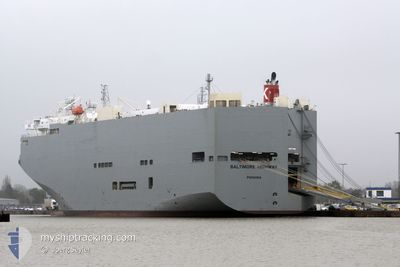
BALTIMORE HIGHWAY
Vehicles Carrier
Current Trip
| Time Travelled | 2 days |
|---|---|
| Remaining Time | --- |
| Distance Travelled | 781.57 nm |
| Remaining Distance | --- |
| AVG Speed | 13.4 Noeuds |
| MAX Speed | 17.1 Noeuds |
| AVG Wind | 15.7 knots |
| MAX Wind | 28.1 knots |
| MIN Temp | 9.9°C / 49.82°F |
| MAX Temp | 20.3°C / 68.54°F |
| Tirant d eau | 7.8 m |
| Position reçue | 1 d depuis |
Current Position
| Longitude | -125.23710° |
|---|---|
| Latitude | 38.38368° |
| Etat | Under way using engine |
| Vitesse | 15 Noeuds |
| Parcours | 283° |
| Zone | North Pacific Ocean |
| Station | T-AIS |
| Position reçue | 1 d depuis |
Info
Information
The current position of BALTIMORE HIGHWAY is in North Pacific Ocean with coordinates 38.38368° / -125.23710° as reported on 2024-04-17 13:57 by AIS to our vessel tracker app. The vessel's current speed is 15 Noeuds and is heading at the port of INCHEON. The estimated time of arrival as calculated by MyShipTracking vessel tracking app is 2024-05-04 21:00 LT
The vessel BALTIMORE HIGHWAY (IMO: 9510149, MMSI: 352517000) is a Vehicles Carrier that was built in 2009 ( 15 Age ). It's sailing under the flag of [PA] Panama.
In this page you can find informations about the vessels current position, last detected port calls, and current voyage information. If the vessels is not in coverage by AIS you will find the latest position.
The current position of BALTIMORE HIGHWAY is detected by our AIS receivers and we are not responsible for the reliability of the data. The last position was recorded while the vessel was in Coverage by the Ais receivers of our vessel tracking app.
The current draught of BALTIMORE HIGHWAY as reported by AIS is 7.8 meters
Weather
| Temperature | 9.6°C / 49.28°F |
|---|---|
| Wind Speed | 25 knots |
| Direction | 151° SSE |
| Pressure | 1014.2 hPa |
| Humidity | 95.9 % |
| Cloud Coverage | 100 % |
Featured Company
Last Port Calls
| Port | Arrival | Departure | Time In Port |
|---|---|---|---|
| 2024-04-16 01:47 | 2024-04-17 00:36 | 22 h | |
| 2024-04-14 01:59 | 2024-04-15 01:02 | 23 h | |
| 2024-03-29 20:36 | 2024-03-30 12:05 | 15 h | |
| 2024-03-26 19:13 | 2024-03-28 13:01 | 1 d | |
| 2024-03-20 02:39 | 2024-03-20 11:37 | 8 h | |
| 2024-03-10 07:31 | 2024-03-10 16:28 | 8 h | |
| 2024-03-09 09:17 | 2024-03-09 15:21 | 6 h | |
| 2024-03-01 22:02 | 2024-03-02 08:41 | 10 h | |
| 2024-02-27 23:28 | 2024-02-29 00:34 | 1 d | |
| 2024-02-18 20:41 | 2024-02-19 03:32 | 6 h |
Most Visited Ports (Last year)
| Port | Arrivals | |
|---|---|---|
| 7 | ||
| 4 | ||
| 4 | ||
| 3 | ||
| 3 | ||
| 2 |
Last Trips
| Origin | Departure | Destination | Arrival | Distance | |
|---|---|---|---|---|---|
| 2024-04-14 18:02 | 2024-04-15 18:47 | 65.98 nm | |||
| 2024-03-30 21:05 | 2024-04-13 18:59 | 5210.83 nm | |||
| 2024-03-28 22:01 | 2024-03-30 05:36 | 407.04 nm | |||
| 2024-03-20 19:37 | 2024-03-27 04:13 | 2595.24 nm | |||
| 2024-03-10 19:28 | 2024-03-20 10:39 | 4006.23 nm | |||
| 2024-03-09 18:21 | 2024-03-10 10:31 | 190.90 nm | |||
| 2024-03-02 10:41 | 2024-03-09 12:17 | 1894.87 nm | |||
| 2024-02-29 02:34 | 2024-03-02 00:02 | 516.37 nm | |||
| 2024-02-19 09:02 | 2024-02-28 01:28 | 3735.47 nm | |||
| 2024-02-17 22:05 | 2024-02-19 02:11 | 478.80 nm |
Events
| Heure | Evenement | Détails | Position/ Destination | Info |
|---|---|---|---|---|
| 2024-04-17 14:02 | Etat Changé | Default Under way using engine |
38.38823 / -125.26305
KR INC
|
Vitesse: 15 kn Parcours: 283° |
| 2024-04-17 13:57 | Hors de la zone couverte |
38.38368 / -125.23710
North Pacific Ocean
KR INC
|
Vitesse: 15 kn Parcours: 283° |
|
| 2024-04-17 11:38 | Etat Changé | Under way using engine Default |
38.26493 / -124.52512
KR INC
|
Vitesse: 14.3 kn Parcours: 281° |
| 2024-04-17 11:29 | Etat Changé | Default Under way using engine |
38.25927 / -124.47887
KR INC
|
Vitesse: 13.8 kn Parcours: 282° |
| 2024-04-17 10:07 | Etat Changé | Under way using engine Default |
38.17812 / -124.13908
KR INC
|
Vitesse: 10.1 kn Parcours: 274° |
| 2024-04-17 10:05 | Etat Changé | Default Under way using engine |
38.17720 / -124.13174
KR INC
|
Vitesse: 11.1 kn Parcours: 281° |
| 2024-04-17 06:59 | Changement d'ETA | 2024/05/04 21:00 2024/05/04 20:00 |
38.09818 / -123.27570
KR INC
|
Vitesse: 10.5 kn Parcours: 319° |
| 2024-04-17 06:55 | Changement d'ETA | 2024/05/04 20:00 2024/05/06 10:00 |
38.08967 / -123.26648
KR INC
|
Vitesse: 10.9 kn Parcours: 319° |
| 2024-04-17 00:41 | Tirant d'eau modifié | 7.8 8.5 |
38.03427 / -122.14908
KR INC
|
Vitesse: 9.5 kn Parcours: 250° |
| 2024-04-17 00:41 | Changement de destination | KR INC US BNC |
38.03427 / -122.14908
KR INC
|
Vitesse: 9.5 kn Parcours: 250° |