
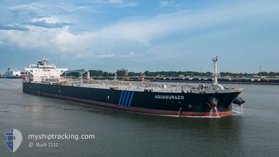
AQUASURAZO
Tanker
Current Trip
| Time Travelled | 3 days |
|---|---|
| Remaining Time | --- |
| Distance Travelled | 145.68 nm |
| Remaining Distance | --- |
| AVG Speed | 9 Noeuds |
| MAX Speed | 13.3 Noeuds |
| AVG Wind | 14.9 knots |
| MAX Wind | 23.8 knots |
| MIN Temp | 22°C / 71.6°F |
| MAX Temp | 23.6°C / 74.48°F |
| Tirant d eau | 12.3 m |
| Position reçue | 18 m depuis |
Current Position
| Longitude | -95.43030° |
|---|---|
| Latitude | 27.74369° |
| Etat | Restricted manoeuverability |
| Vitesse | 0.4 Noeuds |
| Parcours | 188° |
| Zone | Gulf of Mexico |
| Station | T-AIS |
| Position reçue | 18 m depuis |
Info
Information
The current position of AQUASURAZO is in Gulf of Mexico with coordinates 27.74369° / -95.43030° as reported on 2024-04-18 22:54 by AIS to our vessel tracker app. The vessel's current speed is 0.4 Noeuds
The vessel AQUASURAZO (IMO: 9785720, MMSI: 636017858) is a Tanker It's sailing under the flag of [LR] Liberia.
In this page you can find informations about the vessels current position, last detected port calls, and current voyage information. If the vessels is not in coverage by AIS you will find the latest position.
The current position of AQUASURAZO is detected by our AIS receivers and we are not responsible for the reliability of the data. The last position was recorded while the vessel was in Coverage by the Ais receivers of our vessel tracking app.
The current draught of AQUASURAZO as reported by AIS is 12.3 meters
Weather
| Temperature | 23.6°C / 74.48°F |
|---|---|
| Wind Speed | 16 knots |
| Direction | 125° SE |
| Pressure | 1012.3 hPa |
| Humidity | 91.8 % |
| Cloud Coverage | 100 % |
Featured Company
Most Visited Ports (Last year)
| Port | Arrivals | |
|---|---|---|
| 10 | ||
| 7 | ||
| 1 | ||
| 1 | ||
| 1 | ||
| 1 |
Last Trips
| Origin | Departure | Destination | Arrival | Distance | |
|---|---|---|---|---|---|
| 2024-03-26 14:52 | 2024-04-14 05:36 | 5090.88 nm | |||
| 2024-03-04 14:47 | 2024-03-23 15:47 | 4929.12 nm | |||
| 2024-02-27 11:31 | 2024-03-02 00:21 | 601.93 nm | |||
| 2024-02-09 11:52 | 2024-02-26 01:27 | 1722.01 nm | |||
| 2024-01-29 07:56 | 2024-02-08 06:53 | 1528.80 nm |
Events
| Heure | Evenement | Détails | Position/ Destination | Info |
|---|---|---|---|---|
| 2024-04-18 23:11 | Etat Changé | Default Restricted manoeuverability |
27.74186 / -95.43050
USCRP LZ
|
Vitesse: 0.4 kn Parcours: 188° |
| 2024-04-18 22:32 | Etat Changé | Restricted manoeuverability Default |
27.74543 / -95.42949
USCRP LZ
|
Vitesse: 0.1 kn Parcours: 229° |
| 2024-04-18 22:32 | Dans la zone couverte |
27.74543 / -95.42949
Gulf of Mexico
|
Vitesse: 0.1 kn Parcours: 207.2° |
|
| 2024-04-18 21:26 | Etat Changé | Default Restricted manoeuverability |
27.74848 / -95.43153
USCRP LZ
|
Vitesse: 0.1 kn Parcours: 214° |
| 2024-04-18 20:33 | Hors de la zone couverte |
27.75265 / -95.43342
Gulf of Mexico
|
Vitesse: 0.1 kn Parcours: 212.3° |
|
| 2024-04-18 20:19 | Etat Changé | Restricted manoeuverability Default |
27.75316 / -95.43366
USCRP LZ
|
Vitesse: 0.1 kn Parcours: 232° |
| 2024-04-18 19:57 | Etat Changé | Default Restricted manoeuverability |
27.75350 / -95.43472
USCRP LZ
|
Vitesse: 0.2 kn Parcours: 226° |
| 2024-04-18 17:48 | Arret |
27.75550 / -95.44859
USCRP LZ
|
Vitesse: 0.3 kn Parcours: 213° |
|
| 2024-04-18 17:40 | Etat Changé | Restricted manoeuverability Default |
27.75535 / -95.45012
USCRP LZ
|
Vitesse: 0.4 kn Parcours: 192° |
| 2024-04-18 17:35 | Dans la zone couverte |
27.75535 / -95.45012
Gulf of Mexico
|
Vitesse: 0.4 kn Parcours: 92.3° |