
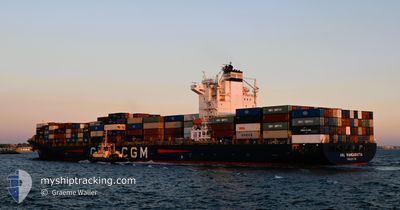
ANL WANGARATTA
Container Ship
Current Trip
| Time Travelled | 4 days |
|---|---|
| Remaining Time | --- |
| Distance Travelled | 1724.39 nm |
| Remaining Distance | 977.33 nm |
| AVG Speed | 16.9 Noeuds |
| MAX Speed | 20 Noeuds |
| AVG Wind | 13.7 knots |
| MAX Wind | 26 knots |
| MIN Temp | 22.5°C / 72.5°F |
| MAX Temp | 29.9°C / 85.82°F |
| Tirant d eau | 10.2 m |
| Position reçue | 3 d depuis |
Current Position
| Longitude | 113.93066° |
|---|---|
| Latitude | -29.72930° |
| Etat | Under way using engine |
| Vitesse | 17.4 Noeuds |
| Parcours | 334.7° |
| Zone | Indian Ocean |
| Station | T-AIS |
| Position reçue | 3 d depuis |
Info
Information
The current position of ANL WANGARATTA is in Indian Ocean with coordinates -29.72930° / 113.93066° as reported on 2024-04-21 16:49 by AIS to our vessel tracker app. The vessel's current speed is 17.4 Noeuds and is heading at the port of PORT KLANG. The estimated time of arrival as calculated by MyShipTracking vessel tracking app is 2024-04-28 13:00 LT
The vessel ANL WANGARATTA (IMO: 9334167, MMSI: 215167000) is a Container Ship that was built in 2008 ( 16 Age ). It's sailing under the flag of [MT] Malta.
In this page you can find informations about the vessels current position, last detected port calls, and current voyage information. If the vessels is not in coverage by AIS you will find the latest position.
The current position of ANL WANGARATTA is detected by our AIS receivers and we are not responsible for the reliability of the data. The last position was recorded while the vessel was in Coverage by the Ais receivers of our vessel tracking app.
The current draught of ANL WANGARATTA as reported by AIS is 10.2 meters
Weather
| Temperature | 29.8°C / 85.64°F |
|---|---|
| Wind Speed | 4 knots |
| Direction | 75° ENE |
| Pressure | 1005.7 hPa |
| Humidity | 70.2 % |
| Cloud Coverage | 96 % |
Featured Company
Last Port Calls
| Port | Arrival | Departure | Time In Port |
|---|---|---|---|
| 2024-04-16 10:10 | 2024-04-21 06:42 | 4 d | |
| 2024-04-09 14:02 | 2024-04-11 04:57 | 1 d | |
| 2024-04-04 15:01 | 2024-04-05 18:05 | 1 d | |
| 2024-03-30 07:03 | 2024-03-31 10:43 | 1 d | |
| 2024-03-28 19:26 | 2024-03-29 05:46 | 10 h | |
| 2024-03-27 17:49 | 2024-03-28 05:21 | 11 h | |
| 2024-03-11 08:28 | 2024-03-13 16:51 | 2 d | |
| 2024-02-28 17:42 | 2024-02-29 09:34 | 15 h | |
| 2024-02-26 23:28 | 2024-02-27 23:49 | 1 d | |
| 2024-02-23 23:03 | 2024-02-24 14:01 | 14 h |
Most Visited Ports (Last year)
| Port | Arrivals | |
|---|---|---|
| 11 | ||
| 7 | ||
| 6 | ||
| 5 | ||
| 5 | ||
| 4 |
Last Trips
| Origin | Departure | Destination | Arrival | Distance | |
|---|---|---|---|---|---|
| 2024-04-11 12:57 | 2024-04-16 18:10 | 2344.85 nm | |||
| 2024-04-06 02:05 | 2024-04-09 22:02 | 224.15 nm | |||
| 2024-03-31 18:43 | 2024-04-04 23:01 | 212.17 nm | |||
| 2024-03-29 13:46 | 2024-03-30 15:03 | 35.98 nm | |||
| 2024-03-28 13:21 | 2024-03-29 03:26 | 36.34 nm | |||
| 2024-03-14 03:51 | 2024-03-28 01:49 | 4305.06 nm | |||
| 2024-02-29 17:34 | 2024-03-11 19:28 | 4161.89 nm | |||
| 2024-02-28 07:49 | 2024-02-29 01:42 | 6.57 nm | |||
| 2024-02-24 22:01 | 2024-02-27 07:28 | 164.56 nm | |||
| 2024-02-10 02:38 | 2024-02-24 07:03 | 4283.59 nm |
Events
| Heure | Evenement | Détails | Position/ Destination | Info |
|---|---|---|---|---|
| 2024-04-21 16:52 | Etat Changé | Default Under way using engine |
-29.71886 / 113.92455
MYPKG
|
Vitesse: 17.4 kn Parcours: 334.7° |
| 2024-04-21 16:49 | Hors de la zone couverte |
-29.72930 / 113.93066
Indian Ocean
MYPKG
|
Vitesse: 17.4 kn Parcours: 334.7° |
|
| 2024-04-21 16:36 | Etat Changé | Under way using engine Default |
-29.78611 / 113.96521
MYPKG
|
Vitesse: 17.2 kn Parcours: 334° |
| 2024-04-21 16:31 | Etat Changé | Default Under way using engine |
-29.80683 / 113.97786
MYPKG
|
Vitesse: 17.2 kn Parcours: 332.8° |
| 2024-04-21 16:26 | Etat Changé | Under way using engine Default |
-29.82768 / 113.99029
MYPKG
|
Vitesse: 17 kn Parcours: 334° |
| 2024-04-21 16:18 | Etat Changé | Default Under way using engine |
-29.86087 / 114.00977
MYPKG
|
Vitesse: 17.5 kn Parcours: 334.6° |
| 2024-04-21 15:58 | Etat Changé | Under way using engine Default |
-29.94571 / 114.06371
MYPKG
|
Vitesse: 17.7 kn Parcours: 328° |
| 2024-04-21 15:55 | Etat Changé | Default Under way using engine |
-29.96184 / 114.07377
MYPKG
|
Vitesse: 17.7 kn Parcours: 331.1° |
| 2024-04-21 15:46 | Etat Changé | Under way using engine Default |
-30.00000 / 114.09784
MYPKG
|
Vitesse: 17.6 kn Parcours: 331° |
| 2024-04-21 15:35 | Dans la zone couverte |
-29.99872 / 114.09700
Indian Ocean
MYPKG
|
Vitesse: 17.7 kn Parcours: 330.4° |