
ANCHORAGE
Dredging or underwater ops
Current Trip
| Time Travelled | 10 h, 20 mins |
|---|---|
| Remaining Time | 6 h, 23 mins |
| Distance Travelled | 110.94 nm |
| Remaining Distance | 69.44 nm |
| AVG Speed | 11.4 Noeuds |
| MAX Speed | 13.5 Noeuds |
| AVG Wind | 25.3 knots |
| MAX Wind | 28.1 knots |
| MIN Temp | 7.8°C / 46.04°F |
| MAX Temp | 9.4°C / 48.92°F |
| Tirant d eau | 6.9 m |
| Position reçue | 1 m depuis |
Current Position
| Longitude | 1.10419° |
|---|---|
| Latitude | 50.78981° |
| Etat | Under way using engine |
| Vitesse | 9.6 Noeuds |
| Parcours | 224.8° |
| Zone | English Channel |
| Station | T-AIS |
| Position reçue | 1 m depuis |
Info
Information
The current position of ANCHORAGE is in English Channel with coordinates 50.78981° / 1.10419° as reported on 2024-04-19 21:24 by AIS to our vessel tracker app. The vessel's current speed is 9.6 Noeuds and is heading at the port of FECAMP. The estimated time of arrival as calculated by MyShipTracking vessel tracking app is 2024-04-20 03:49 LT
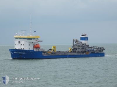
The vessel ANCHORAGE (IMO: 9823792, MMSI: 246400000) is a Dredging or underwater ops It's sailing under the flag of [NL] Netherlands.
In this page you can find informations about the vessels current position, last detected port calls, and current voyage information. If the vessels is not in coverage by AIS you will find the latest position.
The current position of ANCHORAGE is detected by our AIS receivers and we are not responsible for the reliability of the data. The last position was recorded while the vessel was in Coverage by the Ais receivers of our vessel tracking app.
The current draught of ANCHORAGE as reported by AIS is 6.9 meters
Weather
| Temperature | 8.2°C / 46.76°F |
|---|---|
| Wind Speed | 19 knots |
| Direction | 358° N |
| Pressure | 1022.6 hPa |
| Humidity | 64.3 % |
| Cloud Coverage | 69 % |
Featured Company
Last Port Calls
| Port | Arrival | Departure | Time In Port |
|---|---|---|---|
| 2024-04-19 01:34 | 2024-04-19 11:06 | 9 h | |
| 2024-04-16 12:27 | 2024-04-17 11:12 | 22 h | |
| 2024-04-16 05:13 | 2024-04-16 12:02 | 6 h | |
| 2024-04-14 15:49 | 2024-04-16 04:58 | 1 d | |
| 2024-04-13 14:23 | 2024-04-14 10:02 | 19 h | |
| 2024-04-11 14:39 | 2024-04-13 04:54 | 1 d | |
| 2024-04-09 07:52 | 2024-04-10 04:43 | 20 h | |
| 2024-04-07 21:13 | 2024-04-08 08:24 | 11 h | |
| 2024-04-06 20:20 | 2024-04-07 09:11 | 12 h | |
| 2024-04-05 12:53 | 2024-04-05 23:14 | 10 h |
Most Visited Ports (Last year)
| Port | Arrivals | |
|---|---|---|
| 82 | ||
| 23 | ||
| 19 | ||
| 15 | ||
| 9 | ||
| 6 |
Last Trips
| Origin | Departure | Destination | Arrival | Distance | |
|---|---|---|---|---|---|
| 2024-04-17 13:12 | 2024-04-19 03:34 | 324.78 nm | |||
| 2024-04-16 14:02 | 2024-04-16 14:27 | 3.28 nm | |||
| 2024-04-16 06:58 | 2024-04-16 07:13 | 3.00 nm | |||
| 2024-04-14 12:02 | 2024-04-14 17:49 | 40.36 nm | |||
| 2024-04-13 06:54 | 2024-04-13 16:23 | 73.63 nm | |||
| 2024-04-10 06:43 | 2024-04-11 16:39 | 142.51 nm | |||
| 2024-04-08 10:24 | 2024-04-09 09:52 | 199.41 nm | |||
| 2024-04-07 11:11 | 2024-04-07 23:13 | 55.77 nm | |||
| 2024-04-06 01:14 | 2024-04-06 22:20 | 206.48 nm | |||
| 2024-04-05 06:43 | 2024-04-05 14:53 | 73.22 nm |
Events
| Heure | Evenement | Détails | Position/ Destination | Info |
|---|---|---|---|---|
| 2024-04-19 20:14 | Detecté en mer | United Kingdom part of the English Channel |
50.92364 / 1.32038
English Channel
DREDGE AREA 461
|
Vitesse: 9.9 kn Parcours: 224° |
| 2024-04-19 19:59 | Changement de zone | French part of the English Channel United Kingdom part of the English Channel |
50.95423 / 1.36709
English Channel
DREDGE AREA 461
|
Vitesse: 10.2 kn Parcours: 224.7° |
| 2024-04-19 19:16 | Changement de zone | United Kingdom part of the English Channel United Kingdom part of the North Sea |
51.04494 / 1.51193
English Channel
DREDGE AREA 461
|
Vitesse: 11.5 kn Parcours: 227.2° |
| 2024-04-19 16:38 | Changement de zone | United Kingdom part of the North Sea French part of the North Sea |
51.40233 / 2.06449
North Sea
DREDGE AREA 461
|
Vitesse: 10.5 kn Parcours: 291.6° |
| 2024-04-19 15:35 | Changement de zone | French part of the North Sea Belgian part of the North Sea |
51.34843 / 2.33637
North Sea
DREDGE AREA 461
|
Vitesse: 12.1 kn Parcours: 259.1° |
| 2024-04-19 12:11 | Changement de zone | Belgian part of the North Sea Dutch part of the North Sea |
51.40780 / 3.32433
North Sea
DREDGE AREA 461
|
Vitesse: 10.7 kn Parcours: 274.2° |
| 2024-04-19 11:07 | Changement de destination | DREDGE AREA 461 VLISSINGEN BUITENHAV |
51.43972 / 3.60260
DREDGE AREA 461
|
Vitesse: 6.3 kn Parcours: 174.6° |
| 2024-04-19 11:07 | Changement d'ETA | 2024/04/20 03:00 2024/04/19 04:00 |
51.43972 / 3.60260
DREDGE AREA 461
|
Vitesse: 6.3 kn Parcours: 174.6° |
| 2024-04-19 11:06 | PORT DE DEPART |
|
51.44135 / 3.60168
VLISSINGEN BUITENHAV
|
Vitesse: 5.3 kn Parcours: 147° |
| 2024-04-19 10:58 | Démarrage |
51.44934 / 3.59840
[NL] VLISSINGEN STATION
|
Vitesse: 3.3 kn Parcours: 176° |