
ELENE
General Cargo
Current Trip
TCPLS
| Time Travelled | 12 days |
|---|---|
| Remaining Time | --- |
| Distance Travelled | 2490.32 nm |
| Remaining Distance | --- |
| AVG Speed | 10 Noeuds |
| MAX Speed | 14.8 Noeuds |
| AVG Wind | 13.2 knots |
| MAX Wind | 29 knots |
| MIN Temp | 10.2°C / 50.36°F |
| MAX Temp | 21.2°C / 70.16°F |
| Tirant d eau | 5.5 m |
| Position reçue | 4 d depuis |
Current Position
| Longitude | -10.65255° |
|---|---|
| Latitude | 37.39684° |
| Etat | Under way using engine |
| Vitesse | 11.4 Noeuds |
| Parcours | 232.5° |
| Zone | North Atlantic Ocean |
| Station | T-AIS |
| Position reçue | 4 d depuis |
Info
Information
The current position of ELENE is in North Atlantic Ocean with coordinates 37.39684° / -10.65255° as reported on 2024-04-20 10:24 by AIS to our vessel tracker app. The vessel's current speed is 11.4 Noeuds
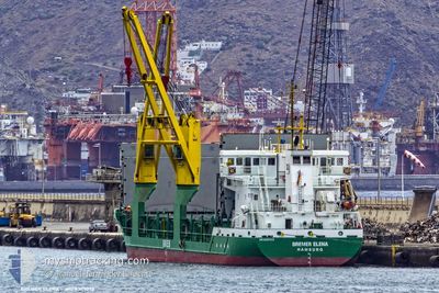
The vessel ELENE (IMO: 9347073, MMSI: 218861000) is a General Cargo that was built in 2007 ( 17 Age ). It's sailing under the flag of [DE] Germany.
In this page you can find informations about the vessels current position, last detected port calls, and current voyage information. If the vessels is not in coverage by AIS you will find the latest position.
The current position of ELENE is detected by our AIS receivers and we are not responsible for the reliability of the data. The last position was recorded while the vessel was in Coverage by the Ais receivers of our vessel tracking app.
The current draught of ELENE as reported by AIS is 5.5 meters
Weather
| Temperature | 20°C / 68°F |
|---|---|
| Wind Speed | 21 knots |
| Direction | 68° ENE |
| Pressure | 1021.1 hPa |
| Humidity | 82.2 % |
| Cloud Coverage | --- |
Featured Company
Last Port Calls
| Port | Arrival | Departure | Time In Port |
|---|---|---|---|
| 2024-04-10 13:35 | 2024-04-12 20:48 | 2 d | |
| 2024-04-06 15:56 | 2024-04-09 18:29 | 3 d | |
| 2024-04-01 15:53 | 2024-04-02 18:05 | 1 d | |
| 2024-03-30 21:23 | 2024-03-30 21:27 | 3 m | |
| 2024-03-27 07:32 | 2024-03-28 19:57 | 1 d | |
| 2024-03-26 18:42 | 2024-03-26 19:33 | 50 m | |
| 2024-03-21 04:56 | 2024-03-21 16:26 | 11 h | |
| 2024-03-20 05:06 | 2024-03-20 05:08 | 2 m | |
| 2024-03-15 08:32 | 2024-03-18 10:42 | 3 d | |
| 2024-03-10 18:07 | 2024-03-12 13:08 | 1 d |
Most Visited Ports (Last year)
| Port | Arrivals | |
|---|---|---|
| 10 | ||
| 10 | ||
| 8 | ||
| 8 | ||
| 7 | ||
| 6 |
Last Trips
| Origin | Departure | Destination | Arrival | Distance | |
|---|---|---|---|---|---|
| 2024-04-09 19:29 | 2024-04-10 15:35 | 201.53 nm | |||
| 2024-04-02 20:05 | 2024-04-06 16:56 | 880.49 nm | |||
| 2024-03-30 22:27 | 2024-04-01 17:53 | 466.00 nm | |||
| 2024-03-28 19:57 | 2024-03-30 22:23 | 409.77 nm | |||
| 2024-03-26 19:33 | 2024-03-27 07:32 | 45.18 nm | |||
| 2024-03-21 17:26 | 2024-03-26 18:42 | 638.74 nm | |||
| 2024-03-20 06:08 | 2024-03-21 05:56 | 230.86 nm | |||
| 2024-03-18 10:42 | 2024-03-20 06:06 | 418.22 nm | |||
| 2024-03-12 14:08 | 2024-03-15 08:32 | 648.92 nm | |||
| 2024-03-09 14:45 | 2024-03-10 19:07 | 258.23 nm |
Events
| Heure | Evenement | Détails | Position/ Destination | Info |
|---|---|---|---|---|
| 2024-04-20 10:24 | Hors de la zone couverte |
37.39684 / -10.65255
North Atlantic Ocean
TCPLS
|
Vitesse: 11.4 kn Parcours: 232.5° |
|
| 2024-04-20 09:43 | Etat Changé | Under way using engine Default |
37.45591 / -10.55655
TCPLS
|
Vitesse: 11.2 kn Parcours: 234° |
| 2024-04-20 09:32 | Dans la zone couverte |
37.45591 / -10.55655
North Atlantic Ocean
TCPLS
|
Vitesse: 11.4 kn Parcours: 233.5° |
|
| 2024-04-20 08:38 | Etat Changé | Default Under way using engine |
37.56988 / -10.37504
TCPLS
|
Vitesse: 10.9 kn Parcours: 232.6° |
| 2024-04-20 08:33 | Hors de la zone couverte |
37.57870 / -10.36033
North Atlantic Ocean
TCPLS
|
Vitesse: 10.9 kn Parcours: 232.6° |
|
| 2024-04-20 08:28 | Etat Changé | Under way using engine Default |
37.58738 / -10.34612
TCPLS
|
Vitesse: 11.1 kn Parcours: 230° |
| 2024-04-20 08:22 | Etat Changé | Default Under way using engine |
37.59983 / -10.32582
TCPLS
|
Vitesse: 10.8 kn Parcours: 229.3° |
| 2024-04-20 01:05 | Tirant d'eau modifié | 5.5 4.1 |
38.42769 / -9.00153
TCPLS
|
Vitesse: 11.1 kn Parcours: 233° |
| 2024-04-20 01:05 | Changement de destination | TCPLS PTSET |
38.42769 / -9.00153
TCPLS
|
Vitesse: 11.1 kn Parcours: 233° |
| 2024-04-20 01:05 | Changement d'ETA | 2024/05/04 08:00 2024/04/17 14:00 |
38.42769 / -9.00153
TCPLS
|
Vitesse: 11.1 kn Parcours: 233° |