
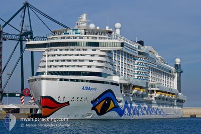
AIDAPERLA
Passenger
Current Trip
| Time Travelled | 7 h, 9 mins |
|---|---|
| Remaining Time | 4 h, 2 mins |
| Distance Travelled | 125.44 nm |
| Remaining Distance | 81.56 nm |
| AVG Speed | 17.2 Noeuds |
| MAX Speed | 20.1 Noeuds |
| AVG Wind | 9.2 knots |
| MAX Wind | 22.3 knots |
| MIN Temp | 13.2°C / 55.76°F |
| MAX Temp | 21.6°C / 70.88°F |
| Tirant d eau | 8.3 m |
| Position reçue | 25 m depuis |
Current Position
| Longitude | -9.80716° |
|---|---|
| Latitude | 42.91812° |
| Etat | Under way using engine |
| Vitesse | 17 Noeuds |
| Parcours | 0.9° |
| Zone | North Atlantic Ocean |
| Station | T-AIS |
| Position reçue | 25 m depuis |
Info
Information
The current position of AIDAPERLA is in North Atlantic Ocean with coordinates 42.91812° / -9.80716° as reported on 2024-04-19 00:29 by AIS to our vessel tracker app. The vessel's current speed is 17 Noeuds and is heading at the port of CORUNA. The estimated time of arrival as calculated by MyShipTracking vessel tracking app is 2024-04-19 04:57 LT
The vessel AIDAPERLA (IMO: 9636967, MMSI: 247385300) is a Passenger It's sailing under the flag of [IT] Italy.
In this page you can find informations about the vessels current position, last detected port calls, and current voyage information. If the vessels is not in coverage by AIS you will find the latest position.
The current position of AIDAPERLA is detected by our AIS receivers and we are not responsible for the reliability of the data. The last position was recorded while the vessel was in Coverage by the Ais receivers of our vessel tracking app.
The current draught of AIDAPERLA as reported by AIS is 8.3 meters
Weather
| Temperature | 13.1°C / 55.58°F |
|---|---|
| Wind Speed | 23 knots |
| Direction | 49° NE |
| Pressure | 1016.4 hPa |
| Humidity | 82.2 % |
| Cloud Coverage | 1 % |
Featured Company
Last Port Calls
| Port | Arrival | Departure | Time In Port |
|---|---|---|---|
| 2024-04-18 07:36 | 2024-04-18 17:46 | 10 h | |
| 2024-04-16 04:10 | 2024-04-16 16:41 | 12 h | |
| 2024-04-14 04:20 | 2024-04-14 22:31 | 18 h | |
| 2024-04-13 05:54 | 2024-04-13 18:06 | 12 h | |
| 2024-04-06 10:03 | 2024-04-06 22:38 | 12 h | |
| 2024-04-05 12:29 | 2024-04-05 23:42 | 11 h | |
| 2024-04-04 10:11 | 2024-04-05 02:50 | 16 h | |
| 2024-04-03 11:13 | 2024-04-03 22:10 | 10 h | |
| 2024-03-31 11:19 | 2024-04-01 02:11 | 14 h | |
| 2024-03-28 10:25 | 2024-03-29 04:23 | 17 h |
Last Trips
| Origin | Departure | Destination | Arrival | Distance | |
|---|---|---|---|---|---|
| 2024-04-16 17:41 | 2024-04-18 08:36 | 654.89 nm | |||
| 2024-04-14 23:31 | 2024-04-16 05:10 | 260.41 nm | |||
| 2024-04-13 19:06 | 2024-04-14 05:20 | 101.50 nm | |||
| 2024-04-06 18:38 | 2024-04-13 06:54 | 2546.21 nm | |||
| 2024-04-05 19:42 | 2024-04-06 06:03 | 131.29 nm | |||
| 2024-04-04 22:50 | 2024-04-05 08:29 | 175.55 nm | |||
| 2024-04-03 18:10 | 2024-04-04 06:11 | 151.17 nm | |||
| 2024-03-31 22:11 | 2024-04-03 07:13 | 444.60 nm | |||
| 2024-03-29 00:23 | 2024-03-31 07:19 | 434.11 nm | |||
| 2024-03-26 20:03 | 2024-03-28 06:25 | 443.46 nm |
Events
| Heure | Evenement | Détails | Position/ Destination | Info |
|---|---|---|---|---|
| 2024-04-19 00:40 | Etat Changé | Default Under way using engine |
42.96833 / -9.80667
ESLCG
|
Vitesse: 17 kn Parcours: 0.9° |
| 2024-04-18 23:46 | Etat Changé | Under way using engine Default |
42.70717 / -9.74638
ESLCG
|
Vitesse: 20 kn Parcours: 357° |
| 2024-04-18 23:46 | Dans la zone couverte |
42.70717 / -9.74638
North Atlantic Ocean
ESLCG
|
Vitesse: 19.3 kn Parcours: 358.9° |
|
| 2024-04-18 21:24 | Etat Changé | Default Under way using engine |
41.97833 / -9.56167
ESLCG
|
Vitesse: 20.1 kn Parcours: 318.6° |
| 2024-04-18 20:59 | Changement de zone | Spanish part of the North Atlantic Ocean Portuguese part of the North Atlantic Ocean |
41.85582 / -9.43207
North Atlantic Ocean
ESLCG
|
Vitesse: 20.1 kn Parcours: 318.6° |
| 2024-04-18 20:59 | Etat Changé | Under way using engine Default |
41.85582 / -9.43207
ESLCG
|
Vitesse: 20 kn Parcours: 319° |
| 2024-04-18 20:59 | Hors de la zone couverte |
41.85582 / -9.43207
North Atlantic Ocean
ESLCG
|
Vitesse: 20.1 kn Parcours: 318.6° |
|
| 2024-04-18 20:42 | Etat Changé | Default Under way using engine |
41.79666 / -9.36333
ESLCG
|
Vitesse: 19.8 kn Parcours: 320.1° |
| 2024-04-18 17:46 | PORT DE DEPART |
|
41.17087 / -8.70510
ESLCG
|
Vitesse: 6.3 kn Parcours: 171° |
| 2024-04-18 17:40 | Démarrage |
41.17943 / -8.70637
[PT] LEIXOES
|
Vitesse: 3.2 kn Parcours: 198° |