
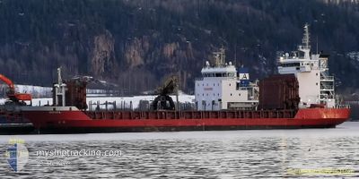
ADRIATA
General Cargo
Current Trip
| Time Travelled | 2 days |
|---|---|
| Remaining Time | --- |
| Distance Travelled | 347.63 nm |
| Remaining Distance | --- |
| AVG Speed | 9.6 Noeuds |
| MAX Speed | 12.6 Noeuds |
| AVG Wind | 10.3 knots |
| MAX Wind | 19 knots |
| MIN Temp | 0.4°C / 32.72°F |
| MAX Temp | 5.1°C / 41.18°F |
| Tirant d eau | 4.1 m |
| Position reçue | 9 h, 36 m depuis |
Current Position
| Longitude | 23.60374° |
|---|---|
| Latitude | 58.08531° |
| Etat | Under way using engine |
| Vitesse | 11.9 Noeuds |
| Parcours | 170° |
| Zone | Gulf of Riga |
| Station | T-AIS |
| Position reçue | 9 h, 36 m depuis |
Info
Information
The current position of ADRIATA is in Gulf of Riga with coordinates 58.08531° / 23.60374° as reported on 2024-04-25 03:03 by AIS to our vessel tracker app. The vessel's current speed is 11.9 Noeuds
The vessel ADRIATA (IMO: 9005376, MMSI: 255805693) is a General Cargo that was built in 1992 ( 32 Age ). It's sailing under the flag of [PT] Portugal.
In this page you can find informations about the vessels current position, last detected port calls, and current voyage information. If the vessels is not in coverage by AIS you will find the latest position.
The current position of ADRIATA is detected by our AIS receivers and we are not responsible for the reliability of the data. The last position was recorded while the vessel was in Coverage by the Ais receivers of our vessel tracking app.
The current draught of ADRIATA as reported by AIS is 4.1 meters
Weather
| Temperature | 5°C / 41°F |
|---|---|
| Wind Speed | 5 knots |
| Direction | 262° W |
| Pressure | 1002.4 hPa |
| Humidity | 93.1 % |
| Cloud Coverage | 100 % |
Featured Company
Last Port Calls
| Port | Arrival | Departure | Time In Port |
|---|---|---|---|
| 2024-04-21 13:16 | 2024-04-22 20:03 | 1 d | |
| 2024-04-20 01:32 | 2024-04-21 06:48 | 1 d | |
| 2024-04-15 03:02 | 2024-04-15 21:04 | 18 h | |
| 2024-04-09 11:45 | 2024-04-10 06:09 | 18 h | |
| 2024-04-05 04:23 | 2024-04-05 18:57 | 14 h | |
| 2024-04-01 20:31 | 2024-04-04 04:12 | 2 d | |
| 2024-03-28 17:00 | 2024-03-30 09:56 | 1 d | |
| 2024-03-26 07:45 | 2024-03-27 07:57 | 1 d | |
| 2024-03-24 04:49 | 2024-03-24 21:13 | 16 h | |
| 2024-03-21 20:04 | 2024-03-23 11:04 | 1 d |
Last Trips
| Origin | Departure | Destination | Arrival | Distance | |
|---|---|---|---|---|---|
| 2024-04-21 09:48 | 2024-04-21 16:16 | 76.34 nm | |||
| 2024-04-15 23:04 | 2024-04-20 04:32 | 688.89 nm | |||
| 2024-04-10 08:09 | 2024-04-15 05:02 | 830.21 nm | |||
| 2024-04-05 20:57 | 2024-04-09 13:45 | 696.70 nm | |||
| 2024-04-04 06:12 | 2024-04-05 06:23 | 227.08 nm | |||
| 2024-03-30 10:56 | 2024-04-01 22:31 | 292.51 nm | |||
| 2024-03-27 09:57 | 2024-03-28 18:00 | 349.47 nm | |||
| 2024-03-24 22:13 | 2024-03-26 09:45 | 388.24 nm | |||
| 2024-03-23 12:04 | 2024-03-24 05:49 | 170.63 nm | |||
| 2024-03-21 06:13 | 2024-03-21 21:04 | 168.06 nm |
Events
| Heure | Evenement | Détails | Position/ Destination | Info |
|---|---|---|---|---|
| 2024-04-25 09:32 | Arret | 5.17 nm, North of RIGA |
57.03271 / 24.12552
LVRIX VIA VAINAMERE
|
Vitesse: Parcours: 266° |
| 2024-04-25 03:03 | Hors de la zone couverte |
58.08531 / 23.60374
Gulf of Riga
LVRIX VIA VAINAMERE
|
Vitesse: 11.9 kn Parcours: 170° |
|
| 2024-04-25 01:02 | Changement de zone | Estonian part of the Gulf of Riga Estonian part of the Baltic Sea |
58.48533 / 23.49082
Gulf of Riga
LVRIX VIA VAINAMERE
|
Vitesse: 12.1 kn Parcours: 178.7° |
| 2024-04-25 01:00 | Dans la zone couverte |
58.48533 / 23.49082
Gulf of Riga
LVRIX VIA VAINAMERE
|
Vitesse: 12.1 kn Parcours: 178.7° |
|
| 2024-04-24 20:21 | Etat Changé | Default Under way using engine |
59.23921 / 23.16373
LVRIX VIA VAINAMERE
|
Vitesse: 12.2 kn Parcours: 218.5° |
| 2024-04-24 20:17 | Hors de la zone couverte |
59.24882 / 23.17887
Baltic Sea
LVRIX VIA VAINAMERE
|
Vitesse: 12.2 kn Parcours: 218.5° |
|
| 2024-04-24 19:41 | Changement de zone | Estonian part of the Baltic Sea Estonian part of the Gulf of Finland |
59.34587 / 23.32416
Baltic Sea
LVRIX VIA VAINAMERE
|
Vitesse: 12 kn Parcours: 231.7° |
| 2024-04-24 13:56 | Detecté en mer | Estonian part of the Gulf of Finland |
59.88005 / 25.32328
Gulf of Finland
LVRIX VIA VAINAMERE
|
Vitesse: 12.2 kn Parcours: 257° |
| 2024-04-24 11:46 | Etat Changé | Under way using engine Default |
60.05775 / 26.10244
LVRIX VIA VAINAMERE
|
Vitesse: 11.9 kn Parcours: 228° |
| 2024-04-24 11:37 | Etat Changé | Default Under way using engine |
60.07766 / 26.14668
LVRIX VIA VAINAMERE
|
Vitesse: 12 kn Parcours: 226.4° |