
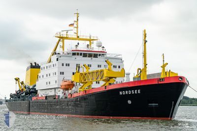
NORDSEE
Trailing Suction Hopper Dredger
Current Trip
DEWVN
| Time Travelled | 12 h, 14 mins |
|---|---|
| Remaining Time | --- |
| Distance Travelled | 25.26 nm |
| Remaining Distance | --- |
| AVG Speed | 10.4 Knoten |
| MAX Speed | 15 Knoten |
| AVG Wind | 9.7 knots |
| MAX Wind | 12 knots |
| MIN Temp | 5.9°C / 42.62°F |
| MAX Temp | 8.1°C / 46.58°F |
| Tiefgang | 7.5 m |
| Position erhalten | 2 m alt |
Current Position
| Länge | 8.16922° |
|---|---|
| Breite | 53.60486° |
| Zustand | At anchor |
| Geschwindigkeit | |
| Kurs | 1° |
| Gebiet | North Sea |
| Station | T-AIS |
| Position erhalten | 2 m alt |
Info
Information
Die aktuelle Position von NORDSEE befindet sich in North Sea mit den Koordinaten 53.60486° / 8.16922°, wie von AIS am 2024-04-18 01:44 an unsere Schiffsverfolgungs-App. Die aktuelle Geschwindigkeit des Schiffes betragt 0 Knoten
Das Schiff NORDSEE (IMO: 7504108, MMSI: 211224140) ist Trailing Suction Hopper Dredger das wurde im Jahr 1978 ( 46 Jahre alt ) gebaut. Es segelt unter der Flagge [DE] Germany.
Auf dieser Seite finden Sie Informationen zur aktuellen Position des Schiffes, zu den zuletzt erkannten Hafenanlaufen und zu aktuellen Reiseinformationen. Wenn die Schiffe nicht von AIS abgedeckt werden, finden Sie die neueste Position.
Die aktuelle Position von NORDSEE wird von unseren AIS-Empfangern erkannt und wir sind nicht fur die Zuverlassigkeit der Daten verantwortlich. Die letzte Position wurde von den Ais-Empfangern unserer Schiffsverfolgungs-App aufgezeichnet, wahrend sich das Schiff in Deckung befand.
Der aktuelle Entwurf von NORDSEE, wie von AIS gemeldet, betragt 7.5 meter
Weather
| Temperature | 5.9°C / 42.62°F |
|---|---|
| Wind Speed | 6 knots |
| Direction | 21° NNE |
| Pressure | 1013.8 hPa |
| Humidity | 80.8 % |
| Cloud Coverage | 71 % |
Featured Company
Last Port Calls
| Port | Arrival | Departure | Time In Port |
|---|---|---|---|
| 2024-04-16 05:22 | 2024-04-17 13:32 | 1 d | |
| 2024-04-16 00:43 | 2024-04-16 01:57 | 1 h | |
| 2024-04-15 20:49 | 2024-04-15 22:07 | 1 h | |
| 2024-04-15 16:33 | 2024-04-15 17:01 | 28 m | |
| 2024-04-15 12:13 | 2024-04-15 13:35 | 1 h | |
| 2024-04-15 03:30 | 2024-04-15 04:11 | 41 m | |
| 2024-04-14 23:13 | 2024-04-15 00:42 | 1 h | |
| 2024-04-14 19:10 | 2024-04-14 20:36 | 1 h | |
| 2024-04-14 14:57 | 2024-04-14 16:05 | 1 h | |
| 2024-04-14 10:32 | 2024-04-14 12:05 | 1 h |
Most Visited Ports (Last year)
| Port | Arrivals | |
|---|---|---|
| 449 | ||
| 2 |
Last Trips
| Origin | Departure | Destination | Arrival | Distance | |
|---|---|---|---|---|---|
| 2024-04-16 03:57 | 2024-04-16 07:22 | 24.82 nm | |||
| 2024-04-16 00:07 | 2024-04-16 02:43 | 25.97 nm | |||
| 2024-04-15 19:01 | 2024-04-15 22:49 | 27.97 nm | |||
| 2024-04-15 15:35 | 2024-04-15 18:33 | 24.84 nm | |||
| 2024-04-15 06:11 | 2024-04-15 14:13 | 58.15 nm | |||
| 2024-04-15 02:42 | 2024-04-15 05:30 | 24.23 nm | |||
| 2024-04-14 22:36 | 2024-04-15 01:13 | 25.64 nm | |||
| 2024-04-14 18:05 | 2024-04-14 21:10 | 25.04 nm | |||
| 2024-04-14 14:05 | 2024-04-14 16:57 | 24.80 nm | |||
| 2024-04-14 09:39 | 2024-04-14 12:32 | 25.91 nm |
Events
| Zeit | Ereignis | Details | Position / Ziel | Information |
|---|---|---|---|---|
| 2024-04-17 20:44 | geänderter Status | At anchor Default |
53.60636 / 8.16885
DEWVN
|
Geschwindigkeit: Kurs: -1° |
| 2024-04-17 20:39 | geänderter Status | Default At anchor |
53.60667 / 8.16833
DEWVN
|
Geschwindigkeit: 0.1 kn Kurs: 140° |
| 2024-04-17 16:01 | geänderter Status | At anchor Under way using engine |
53.60544 / 8.16891
DEWVN
|
Geschwindigkeit: 0.1 kn Kurs: 339° |
| 2024-04-17 15:54 | STOP Bewegung | 4.11 nm, South East of HOOKSIEL |
53.60593 / 8.16854
DEWVN
|
Geschwindigkeit: 0.2 kn Kurs: 342° |
| 2024-04-17 14:53 | START Bewegung | 6.22 nm, North of WANGERSIEL |
53.78652 / 8.04312
DEWVN
|
Geschwindigkeit: 3.7 kn Kurs: 222° |
| 2024-04-17 14:41 | STOP Bewegung | 6.36 nm, North of WANGERSIEL |
53.78858 / 8.04652
DEWVN
|
Geschwindigkeit: 0.2 kn Kurs: 332° |
| 2024-04-17 13:32 | ABFAHRTSHAFEN |
|
53.60628 / 8.15855
DEWVN
|
Geschwindigkeit: 10.5 kn Kurs: 357° |
| 2024-04-17 13:23 | geänderter Status | Under way using engine Moored |
53.59106 / 8.16157
[DE] WILHELMSHAVEN
|
Geschwindigkeit: 2.1 kn Kurs: 352° |
| 2024-04-17 12:04 | START Bewegung |
53.53999 / 8.16710
[DE] WILHELMSHAVEN
|
Geschwindigkeit: 4.9 kn Kurs: 54° |
|
| 2024-04-17 04:28 | geänderte voraussichtliche Ankunftszeit | 2024/04/16 06:00 2024/04/09 06:00 |
53.53855 / 8.16454
[DE] WILHELMSHAVEN
|
Geschwindigkeit: Kurs: 30° |