
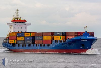
VOHBURG
Container Ship
Current Trip
| Time Travelled | 1 day |
|---|---|
| Remaining Time | -6 mins |
| Distance Travelled | 519.92 nm |
| Remaining Distance | 1.07 nm |
| AVG Speed | 12.6 Knots |
| MAX Speed | 15.4 Knots |
| AVG Wind | 19 knots |
| MAX Wind | 26 knots |
| MIN Temp | 4.2°C / 39.56°F |
| MAX Temp | 6.7°C / 44.06°F |
| Dybgang | 6.8 m |
| Position Modtaget | Nu |
Current Position
| Longitude | -0.17519° |
|---|---|
| Latitude | 53.63389° |
| Status | Under way using engine |
| Fart | 4.5 Knots |
| Kurs | 287° |
| Område | North Sea |
| Station | T-AIS |
| Position Modtaget | Nu |
Info
Information
The current position of VOHBURG is in North Sea with coordinates 53.63389° / -0.17519° as reported on 2024-04-24 08:33 by AIS to our vessel tracker app. The vessel's current speed is 4.5 Knots and is heading at the port of IMMINGHAM. The estimated time of arrival as calculated by MyShipTracking vessel tracking app is 2024-04-24 08:27 LT
The vessel VOHBURG (IMO: 9287807, MMSI: 305773000) is a Container Ship that was built in 2005 ( 19 år gamle ). It's sailing under the flag of [AG] Antigua Barbuda.
In this page you can find informations about the vessels current position, last detected port calls, and current voyage information. If the vessels is not in coverage by AIS you will find the latest position.
The current position of VOHBURG is detected by our AIS receivers and we are not responsible for the reliability of the data. The last position was recorded while the vessel was in Coverage by the Ais receivers of our vessel tracking app.
The current draught of VOHBURG as reported by AIS is 6.8 meters
Weather
| Temperature | 6.2°C / 43.16°F |
|---|---|
| Wind Speed | 12 knots |
| Direction | 353° N |
| Pressure | 1017.4 hPa |
| Humidity | 72.1 % |
| Cloud Coverage | 100 % |
Featured Company
Last Port Calls
| Port | Arrival | Departure | Time In Port |
|---|---|---|---|
| 2024-04-22 11:42 | 2024-04-22 16:13 | 4 h | |
| 2024-04-21 19:17 | 2024-04-22 09:18 | 14 h | |
| 2024-04-19 06:18 | 2024-04-19 23:51 | 17 h | |
| 2024-04-18 04:20 | 2024-04-18 18:31 | 14 h | |
| 2024-04-15 14:10 | 2024-04-15 20:54 | 6 h | |
| 2024-04-14 21:09 | 2024-04-15 11:07 | 13 h | |
| 2024-04-13 01:43 | 2024-04-13 01:53 | 9 m | |
| 2024-04-11 18:12 | |||
| 2024-04-10 14:54 | 2024-04-11 03:00 | 12 h | |
| 2024-04-08 12:20 | 2024-04-08 14:45 | 2 h |
Most Visited Ports (Last year)
| Port | Arrivals | |
|---|---|---|
| 30 | ||
| 15 | ||
| 12 | ||
| 11 | ||
| 10 | ||
| 10 |
Last Trips
| Origin | Departure | Destination | Arrival | Distance | |
|---|---|---|---|---|---|
| 2024-04-22 11:18 | 2024-04-22 13:42 | 35.59 nm | |||
| 2024-04-20 01:51 | 2024-04-21 21:17 | 549.94 nm | |||
| 2024-04-18 21:31 | 2024-04-19 08:18 | 120.61 nm | |||
| 2024-04-15 22:54 | 2024-04-18 07:20 | 564.88 nm | |||
| 2024-04-15 13:07 | 2024-04-15 16:10 | 36.91 nm | |||
| 2024-04-13 03:53 | 2024-04-14 23:09 | 559.84 nm | |||
| 2024-04-11 04:00 | 2024-04-13 03:43 | 204.47 nm | |||
| 2024-04-11 04:00 | 2024-04-11 20:12 | 203.91 nm | |||
| 2024-04-08 16:45 | 2024-04-10 15:54 | 544.89 nm | |||
| 2024-04-08 11:50 | 2024-04-08 14:20 | 35.90 nm |
Events
| Tid | Hændelsen | Detaljer | Position / Dest | Info |
|---|---|---|---|---|
| 2024-04-24 06:35 | Status er ændret | Under way using engine Default |
53.60286 / .31848
GBIMM
|
Fart: 9.2 kn Kurs: 217° |
| 2024-04-24 06:32 | Status er ændret | Default Under way using engine |
53.60722 / .32408
GBIMM
|
Fart: 10.6 kn Kurs: 209.7° |
| 2024-04-24 06:26 | Status er ændret | Under way using engine Default |
53.62172 / .34072
GBIMM
|
Fart: 11.1 kn Kurs: 209° |
| 2024-04-24 06:16 | Indenfor Dækning |
53.62172 / .34072
North Sea
GBIMM
|
Fart: 10.6 kn Kurs: 209.7° |
|
| 2024-04-24 05:29 | Status er ændret | Default Under way using engine |
53.73219 / .54822
GBIMM
|
Fart: 11.6 kn Kurs: 231.3° |
| 2024-04-24 05:22 | Udenfor Dækning |
53.74599 / .57620
North Sea
GBIMM
|
Fart: 11.6 kn Kurs: 231.3° |
|
| 2024-04-24 00:21 | Fundet i havområde | United Kingdom part of the North Sea |
54.31808 / 1.89616
North Sea
GBIMM
|
Fart: 11.7 kn Kurs: 230.5° |
| 2024-04-24 00:21 | Status er ændret | Under way using engine Default |
54.31808 / 1.89616
GBIMM
|
Fart: 11.8 kn Kurs: 232° |
| 2024-04-24 00:21 | Indenfor Dækning |
54.31808 / 1.89616
North Sea
GBIMM
|
Fart: 11.7 kn Kurs: 230.5° |
|
| 2024-04-23 14:51 | Udenfor Dækning |
55.73574 / 4.21792
North Sea
GBIMM
|
Fart: 13.6 kn Kurs: 226.1° |