
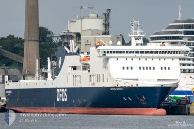
VICTORIA SEAWAYS
Ro-Ro/Passenger Ship
Current Trip
| Time Travelled | 17 h, 23 mins |
|---|---|
| Remaining Time | 2 h, 58 mins |
| Distance Travelled | 265.26 nm |
| Remaining Distance | 133.69 nm |
| AVG Speed | 18.9 Knots |
| MAX Speed | 20.3 Knots |
| AVG Wind | 6.7 knots |
| MAX Wind | 11.1 knots |
| MIN Temp | 2°C / 35.6°F |
| MAX Temp | 4.4°C / 39.92°F |
| Dybgang | 6 m |
| Position Modtaget | 5 h, 49 m siden |
Current Position
| Longitude | 16.10161° |
|---|---|
| Latitude | 55.15423° |
| Status | Under way using engine |
| Fart | 20.1 Knots |
| Kurs | 70.4° |
| Område | Baltic Sea |
| Station | T-AIS |
| Position Modtaget | 5 h, 49 m siden |
Info
Information
The current position of VICTORIA SEAWAYS is in Baltic Sea with coordinates 55.15423° / 16.10161° as reported on 2024-04-23 05:27 by AIS to our vessel tracker app. The vessel's current speed is 20.1 Knots and is heading at the port of KLAIPEDA. The estimated time of arrival as calculated by MyShipTracking vessel tracking app is 2024-04-23 14:14 LT
The vessel VICTORIA SEAWAYS (IMO: 9350721, MMSI: 277408000) is a Ro-Ro/Passenger Ship that was built in 2009 ( 15 år gamle ). It's sailing under the flag of [LT] Lithuania.
In this page you can find informations about the vessels current position, last detected port calls, and current voyage information. If the vessels is not in coverage by AIS you will find the latest position.
The current position of VICTORIA SEAWAYS is detected by our AIS receivers and we are not responsible for the reliability of the data. The last position was recorded while the vessel was in Coverage by the Ais receivers of our vessel tracking app.
The current draught of VICTORIA SEAWAYS as reported by AIS is 6 meters
Weather
| Temperature | 1.9°C / 35.42°F |
|---|---|
| Wind Speed | 12 knots |
| Direction | 219° SW |
| Pressure | 1017.9 hPa |
| Humidity | 96.8 % |
| Cloud Coverage | 100 % |
Featured Company
Last Port Calls
| Port | Arrival | Departure | Time In Port |
|---|---|---|---|
| 2024-04-21 17:30 | 2024-04-22 17:53 | 1 d | |
| 2024-04-20 16:21 | 2024-04-20 20:32 | 4 h | |
| 2024-04-19 15:57 | 2024-04-19 21:04 | 5 h | |
| 2024-04-18 15:17 | 2024-04-18 20:19 | 5 h | |
| 2024-04-17 14:57 | 2024-04-17 19:29 | 4 h | |
| 2024-04-16 14:18 | 2024-04-16 19:11 | 4 h | |
| 2024-04-14 17:30 | 2024-04-15 17:42 | 1 d | |
| 2024-04-13 16:22 | 2024-04-13 21:01 | 4 h | |
| 2024-04-12 16:03 | 2024-04-12 20:37 | 4 h | |
| 2024-04-11 15:20 | 2024-04-11 20:27 | 5 h |
Last Trips
| Origin | Departure | Destination | Arrival | Distance | |
|---|---|---|---|---|---|
| 2024-04-20 23:32 | 2024-04-21 19:30 | 401.61 nm | |||
| 2024-04-19 23:04 | 2024-04-20 19:21 | 397.69 nm | |||
| 2024-04-18 23:19 | 2024-04-19 17:57 | 400.41 nm | |||
| 2024-04-17 21:29 | 2024-04-18 18:17 | 398.03 nm | |||
| 2024-04-16 22:11 | 2024-04-17 16:57 | 399.78 nm | |||
| 2024-04-15 19:42 | 2024-04-16 17:18 | 397.98 nm | |||
| 2024-04-14 00:01 | 2024-04-14 19:30 | 399.67 nm | |||
| 2024-04-12 22:37 | 2024-04-13 19:22 | 398.59 nm | |||
| 2024-04-11 23:27 | 2024-04-12 18:03 | 399.75 nm | |||
| 2024-04-10 22:23 | 2024-04-11 18:20 | 397.88 nm |
Events
| Tid | Hændelsen | Detaljer | Position / Dest | Info |
|---|---|---|---|---|
| 2024-04-23 05:46 | Status er ændret | Default Under way using engine |
55.18932 / 16.27828
LTKLJ-DEKEL-LTKLJ
|
Fart: 20.1 kn Kurs: 70.4° |
| 2024-04-23 05:27 | Udenfor Dækning |
55.15423 / 16.10161
Baltic Sea
LTKLJ-DEKEL-LTKLJ
|
Fart: 20.1 kn Kurs: 70.4° |
|
| 2024-04-23 05:20 | Ændre havområde | Polish part of the Baltic Sea Danish part of the Kattegat |
55.14202 / 16.03950
Baltic Sea
LTKLJ-DEKEL-LTKLJ
|
Fart: 19.7 kn Kurs: 71.5° |
| 2024-04-23 01:47 | Ændre havområde | Danish part of the Kattegat German part of the Baltic Sea |
54.90195 / 14.06608
Kattegat
LTKLJ-DEKEL-LTKLJ
|
Fart: 20 kn Kurs: 84.4° |
| 2024-04-23 00:45 | Status er ændret | Under way using engine Default |
54.84971 / 13.47908
LTKLJ-DEKEL-LTKLJ
|
Fart: 20 kn Kurs: 71° |
| 2024-04-23 00:37 | Status er ændret | Default Under way using engine |
54.83427 / 13.40372
LTKLJ-DEKEL-LTKLJ
|
Fart: 19.8 kn Kurs: 69.5° |
| 2024-04-22 21:56 | Ændre havområde | German part of the Baltic Sea Danish part of the Baltic Sea |
54.41467 / 12.12458
Baltic Sea
LTKLJ-DEKEL-LTKLJ
|
Fart: 19.9 kn Kurs: 91.4° |
| 2024-04-22 20:38 | Ændre havområde | Danish part of the Baltic Sea German part of the Baltic Sea |
54.51012 / 11.42473
Baltic Sea
LTKLJ-DEKEL-LTKLJ
|
Fart: 19.4 kn Kurs: 113.4° |
| 2024-04-22 19:26 | Ændre havområde | German part of the Baltic Sea Danish part of the Baltic Sea |
54.56602 / 10.77724
Baltic Sea
LTKLJ-DEKEL-LTKLJ
|
Fart: 19.7 kn Kurs: 84.4° |
| 2024-04-22 19:08 | Ændre havområde | Danish part of the Baltic Sea German part of the Baltic Sea |
54.55504 / 10.60769
Baltic Sea
LTKLJ-DEKEL-LTKLJ
|
Fart: 18.8 kn Kurs: 70° |