
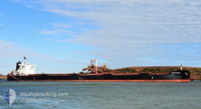
TRUE CHARIOT
Cargo
Current Trip
| Trip Time | 35 days |
|---|---|
| Trip Distance | 9448.03 nm |
| AVG Speed | 11.4 Knots |
| MAX Speed | 15 Knots |
| Dybgang | 17.6 m |
| AVG Wind | 10 knots |
| MAX Wind | 30 knots |
| MIN Temp | 12.3°C / 54.14°F |
| MAX Temp | 30°C / 86°F |
| Position Modtaget | 7 d siden |
Current Position
| Longitude | 103.50884° |
|---|---|
| Latitude | 1.21722° |
| Status | Under way using engine |
| Fart | 11.8 Knots |
| Kurs | 284.9° |
| Område | Singapore Strait |
| Station | T-AIS |
| Position Modtaget | 7 d siden |
Info
Information
The current position of TRUE CHARIOT is in Singapore Strait with coordinates 1.21722° / 103.50884° as reported on 2024-04-17 19:06 by AIS to our vessel tracker app. The vessel's current speed is 11.8 Knots and is currently inside the port of KRISHNAPATNAM.
The vessel TRUE CHARIOT (IMO: 9726774, MMSI: 636018505) is a Cargo It's sailing under the flag of [LR] Liberia.
In this page you can find informations about the vessels current position, last detected port calls, and current voyage information. If the vessels is not in coverage by AIS you will find the latest position.
The current position of TRUE CHARIOT is detected by our AIS receivers and we are not responsible for the reliability of the data. The last position was recorded while the vessel was in Coverage by the Ais receivers of our vessel tracking app.
The current draught of TRUE CHARIOT as reported by AIS is 17.6 meters
Weather
| Temperature | 29.7°C / 85.46°F |
|---|---|
| Wind Speed | 16 knots |
| Direction | 142° SE |
| Pressure | 1004.9 hPa |
| Humidity | 76.1 % |
| Cloud Coverage | 4 % |
Featured Company
Last Port Calls
| Port | Arrival | Departure | Time In Port |
|---|---|---|---|
| 2024-04-24 04:40 | |||
| 2024-03-19 07:24 | |||
| 2024-02-01 08:30 |
Most Visited Ports (Last year)
| Port | Arrivals | |
|---|---|---|
| 2 | ||
| 2 | ||
| 2 | ||
| 2 | ||
| 1 | ||
| 1 |
Last Trips
| Origin | Departure | Destination | Arrival | Distance | |
|---|---|---|---|---|---|
| 2024-03-19 15:24 | 2024-04-24 10:10 | 9448.03 nm |
Events
| Tid | Hændelsen | Detaljer | Position / Dest | Info |
|---|---|---|---|---|
| 2024-04-24 05:21 | STOP Sejllads |
14.25255 / 80.12914
[IN] KRISHNAPATNAM
|
Fart: 0.2 kn Kurs: 32° |
|
| 2024-04-24 04:40 | Skibe i havn |
|
14.24828 / 80.14443
[IN] KRISHNAPATNAM
|
Fart: 5.6 kn Kurs: 262° |
| 2024-04-24 03:11 | START Sejllads | 9.49 nm, East of KRISHNAPATNAM |
14.23203 / 80.30409
PEBGC-SINGAPORE
|
Fart: 4.1 kn Kurs: 59° |
| 2024-04-23 10:59 | STOP Sejllads | 9.32 nm, East of KRISHNAPATNAM |
14.23447 / 80.30145
PEBGC-SINGAPORE
|
Fart: 0.3 kn Kurs: 276° |
| 2024-04-17 19:09 | Status er ændret | Default Under way using engine |
1.21994 / 103.49818
PEBGC-SINGAPORE
|
Fart: 11.8 kn Kurs: 284.9° |
| 2024-04-17 19:06 | Udenfor Dækning |
1.21722 / 103.50884
Singapore Strait
PEBGC-SINGAPORE
|
Fart: 11.8 kn Kurs: 284.9° |
|
| 2024-04-17 18:41 | Ændre havområde | Malaysian part of the Singapore Strait Indonesian part of the Singapore Strait |
1.19654 / 103.58741
Singapore Strait
PEBGC-SINGAPORE
|
Fart: 11.5 kn Kurs: 285° |
| 2024-04-17 17:47 | Ændre havområde | Indonesian part of the Singapore Strait Singaporean part of the Singapore Strait |
1.13441 / 103.72943
Singapore Strait
PEBGC-SINGAPORE
|
Fart: 10.1 kn Kurs: 252.3° |
| 2024-04-17 15:44 | START Sejllads | 2.65 nm, South West of TANAH MERAH |
1.27289 / 103.99756
PEBGC-SINGAPORE
|
Fart: 3.1 kn Kurs: 207° |
| 2024-04-17 15:31 | Dybgangen er ændret | 17.6 17.1 |
1.27591 / 103.99625
PEBGC-SINGAPORE
|
Fart: 0.3 kn Kurs: 89° |