
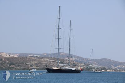
SY MELEK
Sailing
Current Trip
| Time Travelled | 9 days |
|---|---|
| Remaining Time | 2 days |
| Distance Travelled | 9.46 nm |
| Remaining Distance | 3188.04 nm |
| AVG Speed | 11.8 Knots |
| MAX Speed | 12 Knots |
| AVG Wind | 9.6 knots |
| MAX Wind | 10 knots |
| MIN Temp | 26.9°C / 80.42°F |
| MAX Temp | 27.1°C / 80.78°F |
| Dybgang | 10 m |
| Position Modtaget | 8 d siden |
Current Position
| Longitude | -61.53870° |
|---|---|
| Latitude | 17.08509° |
| Status | Under way using engine |
| Fart | 11.6 Knots |
| Kurs | 63.2° |
| Område | Caribbean Sea |
| Station | T-AIS |
| Position Modtaget | 8 d siden |
Info
Information
The current position of SY MELEK is in Caribbean Sea with coordinates 17.08509° / -61.53870° as reported on 2024-04-07 22:59 by AIS to our vessel tracker app. The vessel's current speed is 11.6 Knots and is heading at the port of GIBRALTAR. The estimated time of arrival as calculated by MyShipTracking vessel tracking app is 2024-04-19 05:55 LT
The vessel SY MELEK (IMO: 9586253, MMSI: 319057100) is a Sailing It's sailing under the flag of [KY] Cayman Is.
In this page you can find informations about the vessels current position, last detected port calls, and current voyage information. If the vessels is not in coverage by AIS you will find the latest position.
The current position of SY MELEK is detected by our AIS receivers and we are not responsible for the reliability of the data. The last position was recorded while the vessel was in Coverage by the Ais receivers of our vessel tracking app.
The current draught of SY MELEK as reported by AIS is 10 meters
Weather
| Temperature | 27.3°C / 81.14°F |
|---|---|
| Wind Speed | 9 knots |
| Direction | 106° ESE |
| Pressure | 1014.5 hPa |
| Humidity | 73.9 % |
| Cloud Coverage | 80 % |
Featured Company
Last Port Calls
| Port | Arrival | Departure | Time In Port |
|---|---|---|---|
| 2024-03-26 18:02 | 2024-04-07 21:45 | 12 d | |
| 2024-03-24 21:11 | 2024-03-25 10:51 | 13 h | |
| 2024-03-23 19:03 | 2024-03-24 13:16 | 18 h | |
| 2024-03-22 18:55 | 2024-03-23 13:21 | 18 h | |
| 2024-03-21 20:38 | 2024-03-22 13:10 | 16 h | |
| 2024-03-20 21:07 | 2024-03-21 12:05 | 14 h | |
| 2024-03-12 10:53 | 2024-03-17 11:54 | 5 d | |
| 2024-03-04 13:38 |
Last Trips
| Origin | Departure | Destination | Arrival | Distance | |
|---|---|---|---|---|---|
| 2024-03-25 06:51 | 2024-03-26 14:02 | 126.92 nm | |||
| 2024-03-24 09:16 | 2024-03-24 17:11 | 41.36 nm | |||
| 2024-03-23 09:21 | 2024-03-23 15:03 | 45.27 nm | |||
| 2024-03-22 09:10 | 2024-03-22 14:55 | 38.57 nm | |||
| 2024-03-21 08:05 | 2024-03-21 16:38 | 15.63 nm | |||
| 2024-03-17 07:54 | 2024-03-20 17:07 | 149.45 nm | |||
| 2024-03-04 09:38 | 2024-03-12 06:53 | 552.04 nm |
Events
| Tid | Hændelsen | Detaljer | Position / Dest | Info |
|---|---|---|---|---|
| 2024-04-07 22:59 | Udenfor Dækning |
17.08509 / -61.53870
Caribbean Sea
GIBRALTAR
|
Fart: 11.6 kn Kurs: 63.2° |
|
| 2024-04-07 22:37 | Destination er ændret | GIBRALTAR ST BARTHS |
17.05108 / -61.60738
GIBRALTAR
|
Fart: 11.8 kn Kurs: 63.5° |
| 2024-04-07 22:37 | ETA er ændret | 2024/04/21 12:30 2024/03/25 10:30 |
17.05108 / -61.60738
GIBRALTAR
|
Fart: 11.8 kn Kurs: 63.5° |
| 2024-04-07 22:11 | Indenfor Dækning |
17.01596 / -61.67876
Caribbean Sea
|
Fart: 11.9 kn Kurs: 66.6° |
|
| 2024-04-07 21:45 | Afsejlet fra sidste havn |
|
17.01319 / -61.68527
ST BARTHS
|
Fart: Kurs: 249° |