
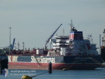
STENA IMPRESSION
Tanker
Current Trip
| Time Travelled | 11 h, 53 mins |
|---|---|
| Remaining Time | --- |
| Distance Travelled | 100.43 nm |
| Remaining Distance | --- |
| AVG Speed | 8.9 Knots |
| MAX Speed | 11.2 Knots |
| AVG Wind | 21.9 knots |
| MAX Wind | 34.3 knots |
| MIN Temp | 3.2°C / 37.76°F |
| MAX Temp | 4.6°C / 40.28°F |
| Dybgang | 11.3 m |
| Position Modtaget | 44 m siden |
Current Position
| Longitude | 2.70110° |
|---|---|
| Latitude | 61.57885° |
| Status | Under way using engine |
| Fart | 7.3 Knots |
| Kurs | 316.2° |
| Område | Norwegian Sea |
| Station | T-AIS |
| Position Modtaget | 44 m siden |
Info
Information
The current position of STENA IMPRESSION is in Norwegian Sea with coordinates 61.57885° / 2.70110° as reported on 2024-04-20 00:43 by AIS to our vessel tracker app. The vessel's current speed is 7.3 Knots and is heading at the port of NEW YORK. The estimated time of arrival as calculated by MyShipTracking vessel tracking app is 2024-04-30 08:00 LT
The vessel STENA IMPRESSION (IMO: 9667461, MMSI: 235108755) is a Tanker It's sailing under the flag of [GB] United Kingdom.
In this page you can find informations about the vessels current position, last detected port calls, and current voyage information. If the vessels is not in coverage by AIS you will find the latest position.
The current position of STENA IMPRESSION is detected by our AIS receivers and we are not responsible for the reliability of the data. The last position was recorded while the vessel was in Coverage by the Ais receivers of our vessel tracking app.
The current draught of STENA IMPRESSION as reported by AIS is 11.3 meters
Weather
| Temperature | 4.4°C / 39.92°F |
|---|---|
| Wind Speed | 25 knots |
| Direction | 355° N |
| Pressure | 1021 hPa |
| Humidity | 56 % |
| Cloud Coverage | 100 % |
Featured Company
Last Port Calls
| Port | Arrival | Departure | Time In Port |
|---|---|---|---|
| 2024-04-17 21:49 | 2024-04-19 13:34 | 1 d | |
| 2024-04-09 06:45 | 2024-04-10 05:54 | 23 h | |
| 2024-04-07 11:13 | 2024-04-08 01:16 | 14 h | |
| 2024-04-04 06:39 | 2024-04-07 01:06 | 2 d | |
| 2024-03-27 14:07 | 2024-04-04 06:27 | 7 d | |
| 2024-02-08 21:34 | 2024-02-10 13:22 | 1 d | |
| 2024-02-04 00:58 | 2024-02-05 04:34 | 1 d |
Most Visited Ports (Last year)
| Port | Arrivals | |
|---|---|---|
| 3 | ||
| 2 | ||
| 2 | ||
| 1 | ||
| 1 | ||
| 1 |
Last Trips
| Origin | Departure | Destination | Arrival | Distance | |
|---|---|---|---|---|---|
| 2024-04-10 06:54 | 2024-04-17 23:49 | 621.30 nm | |||
| 2024-04-08 03:16 | 2024-04-09 07:45 | 239.03 nm | |||
| 2024-04-07 03:06 | 2024-04-07 13:13 | 90.14 nm | |||
| 2024-04-04 08:27 | 2024-04-04 08:39 | 0.80 nm | |||
| 2024-02-10 21:22 | 2024-03-27 15:07 | 11871.78 nm | |||
| 2024-02-05 12:34 | 2024-02-09 05:34 | 255.75 nm | |||
| 2024-01-30 13:45 | 2024-02-04 08:58 | 1373.82 nm |
Events
| Tid | Hændelsen | Detaljer | Position / Dest | Info |
|---|---|---|---|---|
| 2024-04-20 00:46 | Status er ændret | Default Under way using engine |
61.58333 / 2.69167
USNYC
|
Fart: 7.3 kn Kurs: 316.2° |
| 2024-04-19 18:17 | Ændre havområde | Norwegian part of the Norwegian Sea Norwegian part of the North Sea |
61.00528 / 3.87089
Norwegian Sea
USNYC
|
Fart: 9.6 kn Kurs: 318.4° |
| 2024-04-19 14:09 | Status er ændret | Under way using engine Moored |
60.84804 / 4.87223
USNYC
|
Fart: 10.4 kn Kurs: 273.8° |
| 2024-04-19 13:34 | START Sejllads | 0.44 nm, East of MONGSTAD |
60.81925 / 5.03858
USNYC
|
Fart: 3.7 kn Kurs: 323° |
| 2024-04-19 13:34 | Afsejlet fra sidste havn |
|
60.81925 / 5.03858
USNYC
|
Fart: 3 kn Kurs: 326° |
| 2024-04-19 11:52 | ETA er ændret | 2024/04/30 08:00 2024/04/30 20:00 |
60.81464 / 5.04413
[NO] MONGSTAD
|
Fart: Kurs: 316° |
| 2024-04-19 11:45 | ETA er ændret | 2024/04/30 20:00 2024/04/27 20:00 |
60.81464 / 5.04413
[NO] MONGSTAD
|
Fart: Kurs: 316° |
| 2024-04-19 04:13 | Dybgangen er ændret | 11.3 8 |
60.81464 / 5.04415
[NO] MONGSTAD
|
Fart: Kurs: 317° |
| 2024-04-19 04:13 | ETA er ændret | 2024/04/27 20:00 2024/04/16 21:30 |
60.81464 / 5.04415
[NO] MONGSTAD
|
Fart: Kurs: 317° |
| 2024-04-19 04:06 | Destination er ændret | USNYC NOMON |
60.81463 / 5.04413
[NO] MONGSTAD
|
Fart: Kurs: 317° |