
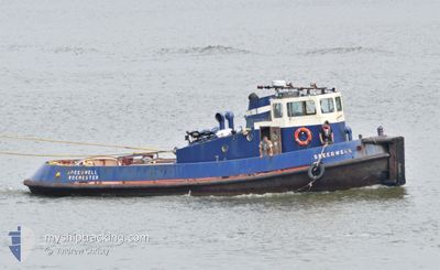
SPEEDWELL
Tug
Current Trip
MEDWAY
| Time Travelled | 40 days |
|---|---|
| Remaining Time | --- |
| Distance Travelled | 120.63 nm |
| Remaining Distance | --- |
| AVG Speed | 6.9 Knots |
| MAX Speed | 11.3 Knots |
| AVG Wind | 14.8 knots |
| MAX Wind | 23.3 knots |
| MIN Temp | 7.6°C / 45.68°F |
| MAX Temp | 14.7°C / 58.46°F |
| Dybgang | 2.4 m |
| Position Modtaget | 8 d siden |
Current Position
| Longitude | 0.47834° |
|---|---|
| Latitude | 51.37911° |
| Status | Under way using engine |
| Fart | |
| Kurs | --- |
| Område | North Sea |
| Station | T-AIS |
| Position Modtaget | 8 d siden |
Info
Information
The current position of SPEEDWELL is in North Sea with coordinates 51.37911° / 0.47834° as reported on 2024-04-07 15:53 by AIS to our vessel tracker app. The vessel's current speed is 0 Knots
The vessel SPEEDWELL (MMSI: 235102255) is a Tug It's sailing under the flag of [GB] United Kingdom.
In this page you can find informations about the vessels current position, last detected port calls, and current voyage information. If the vessels is not in coverage by AIS you will find the latest position.
The current position of SPEEDWELL is detected by our AIS receivers and we are not responsible for the reliability of the data. The last position was recorded while the vessel was in Coverage by the Ais receivers of our vessel tracking app.
The current draught of SPEEDWELL as reported by AIS is 2.4 meters
Weather
| Temperature | 14.3°C / 57.74°F |
|---|---|
| Wind Speed | 19 knots |
| Direction | 210° SSW |
| Pressure | 1008.8 hPa |
| Humidity | 70.6 % |
| Cloud Coverage | 100 % |
Featured Company
Last Port Calls
| Port | Arrival | Departure | Time In Port |
|---|---|---|---|
| 2024-03-07 09:53 | 2024-03-07 10:28 | 34 m | |
| 2024-03-07 06:23 | 2024-03-07 07:28 | 1 h | |
| 2024-02-12 13:41 | 2024-02-12 14:12 | 30 m | |
| 2024-02-09 11:54 |
Last Trips
| Origin | Departure | Destination | Arrival | Distance | |
|---|---|---|---|---|---|
| 2024-03-07 07:28 | 2024-03-07 09:53 | 5.66 nm | |||
| 2024-02-12 14:12 | 2024-03-07 06:23 | 12.63 nm | |||
| 2024-02-09 11:54 | 2024-02-12 13:41 | 5.78 nm |
Events
| Tid | Hændelsen | Detaljer | Position / Dest | Info |
|---|---|---|---|---|
| 2024-04-07 15:53 | Udenfor Dækning |
51.37911 / .47834
North Sea
|
Fart: Kurs: 511° |
|
| 2024-04-07 15:33 | STOP Sejllads | 0.1 nm, North West of MEDWAY BRIDGE |
51.37911 / .47834
MEDWAY
|
Fart: 0.1 kn Kurs: 511° |
| 2024-04-07 15:16 | START Sejllads | 0.55 nm, North East of STROOD |
51.39414 / .50551
MEDWAY
|
Fart: 5.1 kn Kurs: 286° |
| 2024-04-07 13:22 | STOP Sejllads | 0.3 nm, South West of HOO |
51.40542 / .55626
MEDWAY
|
Fart: 0.1 kn Kurs: 511° |
| 2024-04-07 11:24 | START Sejllads | 2.76 nm, East of GILLINGHAM |
51.38205 / .63000
MEDWAY
|
Fart: 3.4 kn Kurs: 42.7° |
| 2024-04-07 10:51 | STOP Sejllads | 2.78 nm, East of GILLINGHAM |
51.38005 / .62937
MEDWAY
|
Fart: 0.1 kn Kurs: 511° |
| 2024-04-07 09:37 | START Sejllads | 0.12 nm, North East of MEDWAY BRIDGE |
51.37998 / .48192
MEDWAY
|
Fart: 6.9 kn Kurs: 80.5° |
| 2024-04-07 09:13 | Indenfor Dækning |
51.37914 / .47837
North Sea
|
Fart: Kurs: 511° |