
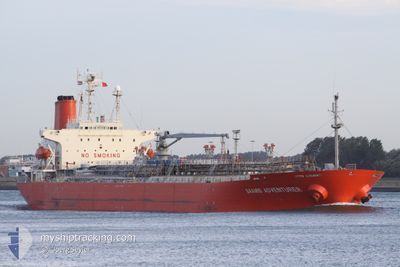
SAAMIS ADVENTURER
Oil/Chemical Tanker
Current Trip
BALONGAN
| Time Travelled | 3 days |
|---|---|
| Remaining Time | --- |
| Distance Travelled | 478.94 nm |
| Remaining Distance | --- |
| AVG Speed | 10.1 Knots |
| MAX Speed | 10.9 Knots |
| AVG Wind | 6.6 knots |
| MAX Wind | 12.2 knots |
| MIN Temp | 27.2°C / 80.96°F |
| MAX Temp | 30.1°C / 86.18°F |
| Dybgang | 6.8 m |
| Position Modtaget | 1 d siden |
Current Position
| Longitude | 110.49204° |
|---|---|
| Latitude | -6.06072° |
| Status | Under way using engine |
| Fart | 10.6 Knots |
| Kurs | 266° |
| Område | Java Sea |
| Station | T-AIS |
| Position Modtaget | 1 d siden |
Info
Information
The current position of SAAMIS ADVENTURER is in Java Sea with coordinates -6.06072° / 110.49204° as reported on 2024-04-23 01:58 by AIS to our vessel tracker app. The vessel's current speed is 10.6 Knots
The vessel SAAMIS ADVENTURER (IMO: 9126285, MMSI: 525020420) is a Oil/Chemical Tanker that was built in 1996 ( 28 år gamle ). It's sailing under the flag of [ID] Indonesia.
In this page you can find informations about the vessels current position, last detected port calls, and current voyage information. If the vessels is not in coverage by AIS you will find the latest position.
The current position of SAAMIS ADVENTURER is detected by our AIS receivers and we are not responsible for the reliability of the data. The last position was recorded while the vessel was in Coverage by the Ais receivers of our vessel tracking app.
The current draught of SAAMIS ADVENTURER as reported by AIS is 6.8 meters
Weather
| Temperature | 29.3°C / 84.74°F |
|---|---|
| Wind Speed | 5 knots |
| Direction | 83° E |
| Pressure | 1008.1 hPa |
| Humidity | 75.5 % |
| Cloud Coverage | 100 % |
Featured Company
Most Visited Ports (Last year)
| Port | Arrivals | |
|---|---|---|
| 13 | ||
| 5 | ||
| 4 | ||
| 3 | ||
| 2 | ||
| 2 |
Last Trips
| Origin | Departure | Destination | Arrival | Distance | |
|---|---|---|---|---|---|
| 2024-04-16 06:40 | 2024-04-20 22:07 | 290.08 nm | |||
| 2024-04-05 21:56 | 2024-04-14 15:46 | 1005.26 nm | |||
| 2024-02-16 08:33 | 2024-04-04 07:32 | 1130.64 nm | |||
| 2024-02-10 08:13 | 2024-02-14 15:51 | 907.34 nm | |||
| 2024-01-15 08:58 | 2024-02-08 10:33 | 1563.52 nm |
Events
| Tid | Hændelsen | Detaljer | Position / Dest | Info |
|---|---|---|---|---|
| 2024-04-23 15:37 | STOP Sejllads |
-6.24123 / 108.42400
BALONGAN
|
Fart: Kurs: 133° |
|
| 2024-04-23 02:21 | Status er ændret | Default Under way using engine |
-6.06307 / 110.42473
BALONGAN
|
Fart: 10.6 kn Kurs: 266° |
| 2024-04-23 01:58 | Udenfor Dækning |
-6.06072 / 110.49204
Java Sea
BALONGAN
|
Fart: 10.6 kn Kurs: 266° |
|
| 2024-04-23 01:40 | Dybgangen er ændret | 6.8 7.5 |
-6.05706 / 110.54332
BALONGAN
|
Fart: 10.6 kn Kurs: 265° |
| 2024-04-23 01:40 | Destination er ændret | BALONGAN CILACAP |
-6.05706 / 110.54332
BALONGAN
|
Fart: 10.6 kn Kurs: 265° |
| 2024-04-23 01:40 | ETA er ændret | 2024/04/24 04:00 2024/04/04 01:00 |
-6.05706 / 110.54332
BALONGAN
|
Fart: 10.6 kn Kurs: 265° |
| 2024-04-23 01:04 | Status er ændret | Under way using engine Default |
-6.03910 / 110.64876
CILACAP
|
Fart: 10.5 kn Kurs: 251° |
| 2024-04-23 01:04 | Indenfor Dækning |
-6.03910 / 110.64876
Java Sea
|
Fart: 10.6 kn Kurs: 250° |
|
| 2024-04-21 15:17 | START Sejllads | 0.53 nm, West of MEKAR PUTIH |
-4.03226 / 116.02886
CILACAP
|
Fart: 3.3 kn Kurs: 245° |
| 2024-04-21 15:17 | Afsejlet fra sidste havn |
|
-4.03226 / 116.02886
CILACAP
|
Fart: 2.9 kn Kurs: 254° |