
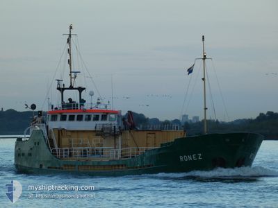
RONEZ
Cement Carrier
Current Trip
| Trip Time | 1 day |
|---|---|
| Trip Distance | 156.58 nm |
| AVG Speed | 6.9 Knots |
| MAX Speed | 10.2 Knots |
| Dybgang | 3.9 m |
| AVG Wind | 10.4 knots |
| MAX Wind | 20.3 knots |
| MIN Temp | 7°C / 44.6°F |
| MAX Temp | 10.2°C / 50.36°F |
| Position Modtaget | 1 m siden |
Current Position
| Longitude | 0.74198° |
|---|---|
| Latitude | 51.44108° |
| Status | Moored |
| Fart | |
| Kurs | 204° |
| Område | North Sea |
| Station | T-AIS |
| Position Modtaget | 1 m siden |
Info
Information
The current position of RONEZ is in North Sea with coordinates 51.44108° / 0.74198° as reported on 2024-04-19 06:29 by AIS to our vessel tracker app. The vessel's current speed is 0 Knots and is currently inside the port of SHEERNESS.
The vessel RONEZ (IMO: 8102476, MMSI: 232003642) is a Cement Carrier that was built in 1982 ( 42 år gamle ). It's sailing under the flag of [GB] United Kingdom.
In this page you can find informations about the vessels current position, last detected port calls, and current voyage information. If the vessels is not in coverage by AIS you will find the latest position.
The current position of RONEZ is detected by our AIS receivers and we are not responsible for the reliability of the data. The last position was recorded while the vessel was in Coverage by the Ais receivers of our vessel tracking app.
The current draught of RONEZ as reported by AIS is 3.9 meters
Weather
| Temperature | 9.8°C / 49.64°F |
|---|---|
| Wind Speed | 17 knots |
| Direction | 285° WNW |
| Pressure | 1014.6 hPa |
| Humidity | 87.1 % |
| Cloud Coverage | 100 % |
Featured Company
Last Port Calls
| Port | Arrival | Departure | Time In Port |
|---|---|---|---|
| 2024-04-18 13:11 | |||
| 2024-04-14 23:39 | 2024-04-17 08:29 | 2 d | |
| 2024-04-14 07:20 | 2024-04-14 20:40 | 13 h | |
| 2024-04-10 19:41 | 2024-04-11 07:44 | 12 h | |
| 2024-04-10 06:07 | 2024-04-10 16:12 | 10 h | |
| 2024-04-02 09:01 | 2024-04-03 16:23 | 1 d | |
| 2024-03-25 19:24 | 2024-03-31 09:12 | 5 d | |
| 2024-03-25 08:18 | 2024-03-25 16:35 | 8 h | |
| 2024-03-21 10:13 | 2024-03-22 17:15 | 1 d | |
| 2024-03-19 06:42 | 2024-03-20 06:16 | 23 h |
Last Trips
| Origin | Departure | Destination | Arrival | Distance | |
|---|---|---|---|---|---|
| 2024-04-17 10:29 | 2024-04-18 14:11 | 156.58 nm | |||
| 2024-04-14 22:40 | 2024-04-15 01:39 | 24.92 nm | |||
| 2024-04-11 08:44 | 2024-04-14 09:20 | 343.61 nm | |||
| 2024-04-10 17:12 | 2024-04-10 20:41 | 27.65 nm | |||
| 2024-04-03 17:23 | 2024-04-10 07:07 | 395.13 nm | |||
| 2024-03-31 10:12 | 2024-04-02 10:01 | 348.90 nm | |||
| 2024-03-25 16:35 | 2024-03-25 19:24 | 27.22 nm | |||
| 2024-03-22 18:15 | 2024-03-25 08:18 | 361.53 nm | |||
| 2024-03-20 06:16 | 2024-03-21 11:13 | 166.20 nm | |||
| 2024-03-18 20:39 | 2024-03-19 06:42 | 78.05 nm |
Events
| Tid | Hændelsen | Detaljer | Position / Dest | Info |
|---|---|---|---|---|
| 2024-04-18 13:32 | Status er ændret | Moored Under way using engine |
51.44104 / .74199
[GB] SHEERNESS
|
Fart: Kurs: 204° |
| 2024-04-18 13:15 | STOP Sejllads |
51.44104 / .74189
[GB] SHEERNESS
|
Fart: 0.3 kn Kurs: 204° |
|
| 2024-04-18 13:11 | Skibe i havn |
|
51.44241 / .74137
[GB] SHEERNESS
|
Fart: 2.7 kn Kurs: 168° |
| 2024-04-18 11:34 | START Sejllads | 8.85 nm, North of WHITSTABLE |
51.50808 / .97521
GBSHS
|
Fart: 4.6 kn Kurs: 253° |
| 2024-04-18 11:08 | Status er ændret | Under way using engine At anchor |
51.50946 / .98088
GBSHS
|
Fart: 0.1 kn Kurs: 238° |
| 2024-04-18 05:46 | Status er ændret | At anchor Under way using engine |
51.50879 / .97813
GBSHS
|
Fart: 0.3 kn Kurs: 55° |
| 2024-04-18 05:45 | STOP Sejllads | 8.88 nm, North of WHITSTABLE |
51.50884 / .97800
GBSHS
|
Fart: 0.2 kn Kurs: 58° |
| 2024-04-17 21:28 | Status er ændret | Under way using engine Default |
51.75345 / 2.19287
GBSHS
|
Fart: 6.1 kn Kurs: 236° |
| 2024-04-17 21:21 | Status er ændret | Default Under way using engine |
51.76019 / 2.20948
GBSHS
|
Fart: 6.2 kn Kurs: 238.4° |
| 2024-04-17 21:18 | Status er ændret | Under way using engine Default |
51.76315 / 2.21689
GBSHS
|
Fart: 6 kn Kurs: 239° |