
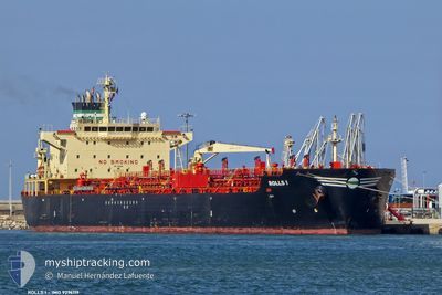
ROLLS I
Oil/Chemical Tanker
Current Trip
| Trip Time | --- |
|---|---|
| Trip Distance | --- |
| AVG Speed | --- |
| MAX Speed | --- |
| Dybgang | --- |
| AVG Wind | --- |
| MAX Wind | --- |
| MIN Temp | --- |
| MAX Temp | --- |
| Position Modtaget | 1 d siden |
Current Position
| Longitude | 35.49081° |
|---|---|
| Latitude | 33.81825° |
| Status | Under way using engine |
| Fart | |
| Kurs | 4° |
| Område | Mediterranean Sea - Eastern Basin |
| Station | T-AIS |
| Position Modtaget | 1 d siden |
Info
Information
The current position of ROLLS I is in Mediterranean Sea - Eastern Basin with coordinates 33.81825° / 35.49081° as reported on 2024-04-18 19:24 by AIS to our vessel tracker app. The vessel's current speed is 0 Knots and is currently inside the port of MERSIN.
The vessel ROLLS I (IMO: 9296119, MMSI: 374496000) is a Oil/Chemical Tanker that was built in 2005 ( 19 år gamle ). It's sailing under the flag of [PA] Panama.
In this page you can find informations about the vessels current position, last detected port calls, and current voyage information. If the vessels is not in coverage by AIS you will find the latest position.
The current position of ROLLS I is detected by our AIS receivers and we are not responsible for the reliability of the data. The last position was recorded while the vessel was in Coverage by the Ais receivers of our vessel tracking app.
The current draught of ROLLS I as reported by AIS is 7.5 meters
Weather
| Temperature | 18.7°C / 65.66°F |
|---|---|
| Wind Speed | 8 knots |
| Direction | 228° SW |
| Pressure | 1011.7 hPa |
| Humidity | 77.6 % |
| Cloud Coverage | 72 % |
Featured Company
Last Port Calls
| Port | Arrival | Departure | Time In Port |
|---|---|---|---|
| 2024-04-16 20:21 | |||
| 2024-04-10 14:39 | 2024-04-11 19:00 | 1 d | |
| 2024-03-30 02:06 | 2024-03-30 05:07 | 3 h | |
| 2024-03-26 12:37 | 2024-03-28 07:33 | 1 d | |
| 2024-03-24 20:57 | |||
| 2024-03-14 08:11 | 2024-03-16 03:51 | 1 d | |
| 2024-03-06 07:51 | 2024-03-06 13:20 | 5 h | |
| 2024-03-05 17:11 | |||
| 2024-03-04 23:40 | |||
| 2024-02-19 19:23 | 2024-02-22 12:15 | 2 d |
Last Trips
| Origin | Departure | Destination | Arrival | Distance | |
|---|---|---|---|---|---|
| 2024-04-11 21:00 | 2024-04-16 23:21 | 1520.24 nm | |||
| 2024-03-30 07:07 | 2024-04-10 16:39 | 1917.11 nm | |||
| 2024-03-28 10:33 | 2024-03-30 04:06 | 383.21 nm | |||
| 2024-03-16 05:51 | 2024-03-24 22:57 | 1531.10 nm | |||
| 2024-03-06 15:20 | 2024-03-14 10:11 | 1127.99 nm | |||
| 2024-02-22 14:15 | 2024-03-05 01:40 | 1252.57 nm | |||
| 2024-02-19 18:36 | 2024-02-19 21:23 | 22.30 nm | |||
| 2024-02-14 03:19 | 2024-02-18 17:20 | 1102.86 nm | |||
| 2024-01-26 06:43 | 2024-02-11 20:15 | 2461.04 nm |
Events
| Tid | Hændelsen | Detaljer | Position / Dest | Info |
|---|---|---|---|---|
| 2024-04-18 19:24 | Udenfor Dækning |
33.81825 / 35.49081
Mediterranean Sea - Eastern Basin
SEA FOR ORDERS
|
Fart: Kurs: 346.2° |
|
| 2024-04-18 19:24 | Indenfor Dækning |
33.81825 / 35.49081
Mediterranean Sea - Eastern Basin
SEA FOR ORDERS
|
Fart: Kurs: 346.2° |
|
| 2024-04-18 14:38 | Udenfor Dækning |
33.81826 / 35.49081
Mediterranean Sea - Eastern Basin
SEA FOR ORDERS
|
Fart: Kurs: 79.9° |
|
| 2024-04-18 11:39 | ETA er ændret | 2024/04/19 14:00 2024/04/15 14:00 |
33.81825 / 35.49080
SEA FOR ORDERS
|
Fart: Kurs: 292° |
| 2024-04-18 11:32 | Status er ændret | Under way using engine Moored |
33.81826 / 35.49079
SEA FOR ORDERS
|
Fart: Kurs: 308° |
| 2024-04-18 10:06 | STOP Sejllads | 6.14 nm, South of BEIRUT |
33.81825 / 35.49081
SEA FOR ORDERS
|
Fart: Kurs: 163° |
| 2024-04-18 10:03 | START Sejllads | 3.47 nm, South of BEIRUT |
33.85866 / 35.51369
SEA FOR ORDERS
|
Fart: 55.1 kn Kurs: 216° |
| 2024-04-18 00:53 | Indenfor Dækning |
33.81829 / 35.49082
Mediterranean Sea - Eastern Basin
|
Fart: Kurs: 101.4° |
|
| 2024-04-17 23:09 | Udenfor Dækning |
33.81820 / 35.49082
Mediterranean Sea - Eastern Basin
|
Fart: Kurs: 310.9° |
|
| 2024-04-17 22:04 | STOP Sejllads | 5.84 nm, South of BEIRUT |
33.82254 / 35.49429
SEA FOR ORDERS
|
Fart: Kurs: 163° |