
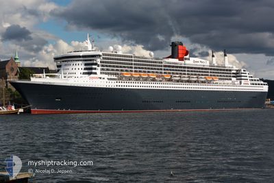
QUEEN MARY 2
Passengers Ship
Current Trip
| Trip Time | 1 day |
|---|---|
| Trip Distance | 713.98 nm |
| AVG Speed | 18.2 Knots |
| MAX Speed | 22.9 Knots |
| Dybgang | 10.2 m |
| AVG Wind | 16.2 knots |
| MAX Wind | 23 knots |
| MIN Temp | 12.6°C / 54.68°F |
| MAX Temp | 20.3°C / 68.54°F |
| Position Modtaget | 3 m siden |
Current Position
| Longitude | -9.12525° |
|---|---|
| Latitude | 38.70958° |
| Status | Moored |
| Fart | |
| Kurs | 56° |
| Område | North Atlantic Ocean |
| Station | T-AIS |
| Position Modtaget | 3 m siden |
Info
Information
The current position of QUEEN MARY 2 is in North Atlantic Ocean with coordinates 38.70958° / -9.12525° as reported on 2024-04-25 10:40 by AIS to our vessel tracker app. The vessel's current speed is 0 Knots and is currently inside the port of LISBOA.
The vessel QUEEN MARY 2 (IMO: 9241061, MMSI: 310627000) is a Passengers Ship that was built in 2003 ( 21 år gamle ). It's sailing under the flag of [BM] Bermuda.
In this page you can find informations about the vessels current position, last detected port calls, and current voyage information. If the vessels is not in coverage by AIS you will find the latest position.
The current position of QUEEN MARY 2 is detected by our AIS receivers and we are not responsible for the reliability of the data. The last position was recorded while the vessel was in Coverage by the Ais receivers of our vessel tracking app.
The current draught of QUEEN MARY 2 as reported by AIS is 10.2 meters
Weather
| Temperature | 17°C / 62.6°F |
|---|---|
| Wind Speed | 13 knots |
| Direction | 342° NNW |
| Pressure | 1014.5 hPa |
| Humidity | 55.6 % |
| Cloud Coverage | 56 % |
Featured Company
Last Port Calls
| Port | Arrival | Departure | Time In Port |
|---|---|---|---|
| 2024-04-25 06:33 | |||
| 2024-04-23 05:03 | 2024-04-23 18:27 | 13 h | |
| 2024-04-15 09:05 | 2024-04-15 18:50 | 9 h | |
| 2024-04-12 02:52 | 2024-04-14 00:57 | 1 d | |
| 2024-04-09 02:40 | 2024-04-09 17:36 | 14 h | |
| 2024-04-05 02:37 | 2024-04-05 14:55 | 12 h | |
| 2024-03-31 00:53 | 2024-03-31 16:01 | 15 h | |
| 2024-03-24 22:09 | 2024-03-25 14:56 | 16 h | |
| 2024-03-21 22:02 | 2024-03-23 12:02 | 1 d | |
| 2024-03-12 21:35 | 2024-03-14 12:55 | 1 d |
Last Trips
| Origin | Departure | Destination | Arrival | Distance | |
|---|---|---|---|---|---|
| 2024-04-23 19:27 | 2024-04-25 07:33 | 713.98 nm | |||
| 2024-04-15 20:50 | 2024-04-23 06:03 | 3835.81 nm | |||
| 2024-04-14 02:57 | 2024-04-15 11:05 | 723.06 nm | |||
| 2024-04-09 19:36 | 2024-04-12 04:52 | 828.53 nm | |||
| 2024-04-05 18:55 | 2024-04-09 04:40 | 1561.57 nm | |||
| 2024-03-31 21:31 | 2024-04-05 06:37 | 2108.11 nm | |||
| 2024-03-25 22:56 | 2024-03-31 06:23 | 1410.74 nm | |||
| 2024-03-23 20:02 | 2024-03-25 06:09 | 460.05 nm | |||
| 2024-03-14 20:55 | 2024-03-22 06:02 | 1763.61 nm | |||
| 2024-03-09 18:22 | 2024-03-13 05:35 | 1528.85 nm |
Events
| Tid | Hændelsen | Detaljer | Position / Dest | Info |
|---|---|---|---|---|
| 2024-04-25 09:43 | Status er ændret | Moored Default |
38.70958 / -9.12526
[PT] LISBOA
|
Fart: Kurs: 56° |
| 2024-04-25 09:40 | Status er ændret | Default Moored |
38.70957 / -9.12525
[PT] LISBOA
|
Fart: Kurs: 56° |
| 2024-04-25 07:02 | Status er ændret | Moored Under way using engine |
38.70955 / -9.12521
[PT] LISBOA
|
Fart: 0.2 kn Kurs: 55° |
| 2024-04-25 06:41 | STOP Sejllads |
38.70874 / -9.12445
[PT] LISBOA
|
Fart: 0.2 kn Kurs: 54° |
|
| 2024-04-25 06:33 | Skibe i havn |
|
38.70779 / -9.12290
[PT] LISBOA
|
Fart: 1.1 kn Kurs: 40° |
| 2024-04-25 00:46 | ETA er ændret | 2024/04/25 05:45 2024/04/25 05:30 |
37.39427 / -10.11964
ES LPA > PT LIS
|
Fart: 17.1 kn Kurs: 26.9° |
| 2024-04-24 23:47 | Status er ændret | Under way using engine Default |
37.14749 / -10.26547
ES LPA > PT LIS
|
Fart: 14.1 kn Kurs: 26° |
| 2024-04-24 23:42 | Status er ændret | Default Under way using engine |
37.13159 / -10.27510
ES LPA > PT LIS
|
Fart: 14.1 kn Kurs: 25° |
| 2024-04-24 16:17 | Ændre havområde | Portuguese part of the North Atlantic Ocean Moroccan part of the North Atlantic Ocean |
34.93651 / -11.55337
North Atlantic Ocean
ES LPA > PT LIS
|
Fart: 21.7 kn Kurs: 24.2° |
| 2024-04-24 13:09 | Status er ændret | Under way using engine Default |
33.91168 / -12.13857
ES LPA > PT LIS
|
Fart: 21.9 kn Kurs: 25° |