
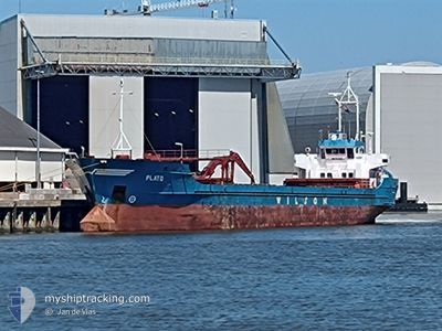
PLATO
General Cargo
Current Trip
| Time Travelled | 11 h, 10 mins |
|---|---|
| Remaining Time | --- |
| Distance Travelled | 98.31 nm |
| Remaining Distance | --- |
| AVG Speed | 9.2 Knots |
| MAX Speed | 12.3 Knots |
| AVG Wind | 8.1 knots |
| MAX Wind | 15.2 knots |
| MIN Temp | 3.1°C / 37.58°F |
| MAX Temp | 7.8°C / 46.04°F |
| Dybgang | 5 m |
| Position Modtaget | 3 h, 43 m siden |
Current Position
| Longitude | 8.30907° |
|---|---|
| Latitude | 54.00501° |
| Status | Under way using engine |
| Fart | 11.8 Knots |
| Kurs | 280.1° |
| Område | North Sea |
| Station | T-AIS |
| Position Modtaget | 3 h, 43 m siden |
Info
Information
The current position of PLATO is in North Sea with coordinates 54.00501° / 8.30907° as reported on 2024-04-24 15:33 by AIS to our vessel tracker app. The vessel's current speed is 11.8 Knots and is heading at the port of NEW ROSS. The estimated time of arrival as calculated by MyShipTracking vessel tracking app is 2024-04-28 19:00 LT
The vessel PLATO (IMO: 8822636, MMSI: 314189000) is a General Cargo that was built in 1989 ( 35 år gamle ). It's sailing under the flag of [BB] Barbados.
In this page you can find informations about the vessels current position, last detected port calls, and current voyage information. If the vessels is not in coverage by AIS you will find the latest position.
The current position of PLATO is detected by our AIS receivers and we are not responsible for the reliability of the data. The last position was recorded while the vessel was in Coverage by the Ais receivers of our vessel tracking app.
The current draught of PLATO as reported by AIS is 5 meters
Weather
| Temperature | 7.6°C / 45.68°F |
|---|---|
| Wind Speed | 14 knots |
| Direction | 358° N |
| Pressure | 1005.1 hPa |
| Humidity | 71 % |
| Cloud Coverage | 24 % |
Featured Company
Last Port Calls
| Port | Arrival | Departure | Time In Port |
|---|---|---|---|
| 2024-04-23 16:53 | 2024-04-24 08:06 | 15 h | |
| 2024-04-20 22:31 | 2024-04-22 15:08 | 1 d | |
| 2024-04-20 13:16 | 2024-04-20 13:20 | 4 m | |
| 2024-04-17 01:47 | 2024-04-18 11:29 | 1 d | |
| 2024-04-10 12:11 | 2024-04-13 01:00 | 2 d | |
| 2024-04-04 06:07 | 2024-04-05 23:59 | 1 d | |
| 2024-04-01 18:33 | 2024-04-01 19:28 | 54 m | |
| 2024-03-30 01:41 | 2024-03-31 18:09 | 1 d | |
| 2024-03-26 15:57 | 2024-03-27 13:56 | 21 h | |
| 2024-03-24 04:03 | 2024-03-26 13:12 | 2 d |
Last Trips
| Origin | Departure | Destination | Arrival | Distance | |
|---|---|---|---|---|---|
| 2024-04-22 17:08 | 2024-04-23 18:53 | 172.52 nm | |||
| 2024-04-20 15:20 | 2024-04-21 00:31 | 83.50 nm | |||
| 2024-04-18 13:29 | 2024-04-20 15:16 | 390.15 nm | |||
| 2024-04-13 02:00 | 2024-04-17 03:47 | 732.45 nm | |||
| 2024-04-06 01:59 | 2024-04-10 13:11 | 714.89 nm | |||
| 2024-04-01 21:28 | 2024-04-04 08:07 | 423.40 nm | |||
| 2024-03-31 20:09 | 2024-04-01 20:33 | 222.39 nm | |||
| 2024-03-27 14:56 | 2024-03-30 02:41 | 534.63 nm | |||
| 2024-03-26 14:12 | 2024-03-26 16:57 | 13.05 nm | |||
| 2024-03-23 04:01 | 2024-03-24 05:03 | 195.59 nm |
Events
| Tid | Hændelsen | Detaljer | Position / Dest | Info |
|---|---|---|---|---|
| 2024-04-24 15:38 | Status er ændret | Default Under way using engine |
54.00500 / 8.27667
IENRS
|
Fart: 11.8 kn Kurs: 280.1° |
| 2024-04-24 15:33 | Status er ændret | Under way using engine Default |
54.00501 / 8.30908
IENRS
|
Fart: 11.7 kn Kurs: 282° |
| 2024-04-24 15:33 | Udenfor Dækning |
54.00501 / 8.30908
North Sea
IENRS
|
Fart: 11.8 kn Kurs: 280.1° |
|
| 2024-04-24 14:56 | Status er ændret | Default Under way using engine |
53.97391 / 8.51252
IENRS
|
Fart: 11.7 kn Kurs: 280.8° |
| 2024-04-24 11:49 | START Sejllads | 1.31 nm, South of BRUNSBUETTEL |
53.88197 / 9.16893
IENRS
|
Fart: 6.6 kn Kurs: 268.6° |
| 2024-04-24 11:48 | STOP Sejllads | 1.34 nm, South of BRUNSBUETTEL |
53.88203 / 9.17211
IENRS
|
Fart: Kurs: 0° |
| 2024-04-24 10:14 | START Sejllads | 0.74 nm, South West of GLUECKSTADT |
53.77776 / 9.39457
IENRS
|
Fart: 8.4 kn Kurs: 340.4° |
| 2024-04-24 10:14 | STOP Sejllads | 0.79 nm, South West of GLUECKSTADT |
53.77591 / 9.39566
IENRS
|
Fart: Kurs: 0° |
| 2024-04-24 08:13 | Status er ændret | Under way using engine Moored |
53.55073 / 9.82710
IENRS
|
Fart: 10.9 kn Kurs: 288.4° |
| 2024-04-24 08:06 | Afsejlet fra sidste havn |
|
53.54567 / 9.85596
IENRS
|
Fart: 8.4 kn Kurs: 286° |