
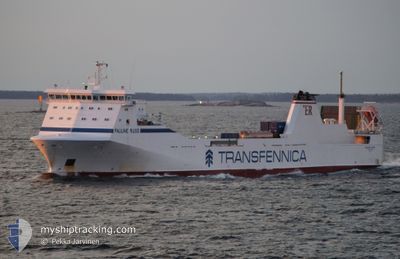
PAULINE RUSS
Ro-Ro Cargo
Current Trip
| Trip Time | 2 days |
|---|---|
| Trip Distance | 527.59 nm |
| AVG Speed | 10.5 Knots |
| MAX Speed | 10.5 Knots |
| Dybgang | 5.6 m |
| AVG Wind | 14.3 knots |
| MAX Wind | 30.8 knots |
| MIN Temp | 9.9°C / 49.82°F |
| MAX Temp | 18.3°C / 64.94°F |
| Position Modtaget | 2 m siden |
Current Position
| Longitude | 5.35920° |
|---|---|
| Latitude | 43.31708° |
| Status | Moored |
| Fart | |
| Kurs | 238° |
| Område | Mediterranean Sea - Western Basin |
| Station | T-AIS |
| Position Modtaget | 2 m siden |
Info
Information
The current position of PAULINE RUSS is in Mediterranean Sea - Western Basin with coordinates 43.31708° / 5.35920° as reported on 2024-04-18 07:12 by AIS to our vessel tracker app. The vessel's current speed is 0 Knots and is currently inside the port of MARSEILLE.
The vessel PAULINE RUSS (IMO: 9198989, MMSI: 255805939) is a Ro-Ro Cargo that was built in 1999 ( 25 år gamle ). It's sailing under the flag of [PT] Portugal.
In this page you can find informations about the vessels current position, last detected port calls, and current voyage information. If the vessels is not in coverage by AIS you will find the latest position.
The current position of PAULINE RUSS is detected by our AIS receivers and we are not responsible for the reliability of the data. The last position was recorded while the vessel was in Coverage by the Ais receivers of our vessel tracking app.
The current draught of PAULINE RUSS as reported by AIS is 5.6 meters
Weather
| Temperature | 9.4°C / 48.92°F |
|---|---|
| Wind Speed | 24 knots |
| Direction | 325° NW |
| Pressure | 1013.2 hPa |
| Humidity | 67.3 % |
| Cloud Coverage | --- |
Featured Company
Last Port Calls
| Port | Arrival | Departure | Time In Port |
|---|---|---|---|
| 2024-04-18 03:47 | |||
| 2024-04-15 05:57 | 2024-04-15 14:30 | 8 h | |
| 2024-04-13 11:26 | 2024-04-13 20:01 | 8 h | |
| 2024-04-10 19:15 | 2024-04-11 16:20 | 21 h | |
| 2024-04-08 03:25 | 2024-04-08 16:36 | 13 h | |
| 2024-04-05 10:09 | 2024-04-05 20:16 | 10 h | |
| 2024-04-03 09:02 | 2024-04-04 00:55 | 15 h | |
| 2024-04-01 09:26 | 2024-04-02 01:43 | 16 h | |
| 2024-03-27 10:19 | 2024-03-28 19:42 | 1 d | |
| 2024-03-23 01:57 | 2024-03-23 16:43 | 14 h |
Most Visited Ports (Last year)
| Port | Arrivals | |
|---|---|---|
| 48 | ||
| 47 | ||
| 39 | ||
| 5 | ||
| 1 |
Last Trips
| Origin | Departure | Destination | Arrival | Distance | |
|---|---|---|---|---|---|
| 2024-04-15 15:30 | 2024-04-18 05:47 | 527.59 nm | |||
| 2024-04-13 21:01 | 2024-04-15 06:57 | 370.84 nm | |||
| 2024-04-11 18:20 | 2024-04-13 12:26 | 405.60 nm | |||
| 2024-04-08 17:36 | 2024-04-10 21:15 | 526.49 nm | |||
| 2024-04-05 22:16 | 2024-04-08 04:25 | 515.82 nm | |||
| 2024-04-04 01:55 | 2024-04-05 12:09 | 407.96 nm | |||
| 2024-04-02 02:43 | 2024-04-03 10:02 | 363.52 nm | |||
| 2024-03-28 20:42 | 2024-04-01 10:26 | 514.46 nm | |||
| 2024-03-23 17:43 | 2024-03-27 11:19 | 729.48 nm | |||
| 2024-03-20 20:14 | 2024-03-23 02:57 | 516.85 nm |
Events
| Tid | Hændelsen | Detaljer | Position / Dest | Info |
|---|---|---|---|---|
| 2024-04-18 04:32 | Status er ændret | Moored Under way using engine |
43.31706 / 5.35923
[FR] MARSEILLE
|
Fart: Kurs: 238° |
| 2024-04-18 04:18 | STOP Sejllads |
43.31667 / 5.35750
[FR] MARSEILLE
|
Fart: 0.3 kn Kurs: 194° |
|
| 2024-04-18 03:47 | Skibe i havn |
|
43.34919 / 5.30551
[FR] MARSEILLE
|
Fart: 9.7 kn Kurs: 54° |
| 2024-04-18 02:17 | Status er ændret | Under way using engine Default |
43.16268 / 5.11139
FRMRS
|
Fart: 10.7 kn Kurs: 57° |
| 2024-04-18 02:05 | Status er ændret | Default Under way using engine |
43.14250 / 5.06983
FRMRS
|
Fart: 10.7 kn Kurs: 57° |
| 2024-04-18 01:32 | Ændre havområde | French part of the Mediterranean Sea - Western Basin Spanish part of the Balearic Sea |
43.08583 / 4.95867
Mediterranean Sea - Western Basin
FRMRS
|
Fart: 11.1 kn Kurs: 54° |
| 2024-04-18 01:29 | Status er ændret | Under way using engine Default |
43.08117 / 4.94950
FRMRS
|
Fart: 11.1 kn Kurs: 54° |
| 2024-04-18 01:24 | Indenfor Dækning |
43.08583 / 4.95867
Mediterranean Sea - Western Basin
FRMRS
|
Fart: 11.1 kn Kurs: 54° |
|
| 2024-04-17 12:47 | Status er ændret | Default Under way using engine |
41.51797 / 2.87847
FRMRS
|
Fart: 11.2 kn Kurs: 45° |
| 2024-04-17 12:46 | Udenfor Dækning |
41.51390 / 2.87308
Balearic Sea
FRMRS
|
Fart: 11.2 kn Kurs: 45° |