
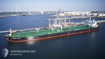
ORANGE STARS
Crude Oil Tanker
Current Trip
GR GYT (OPL)
| Time Travelled | 13 days |
|---|---|
| Remaining Time | --- |
| Distance Travelled | 3083.83 nm |
| Remaining Distance | --- |
| AVG Speed | 11.7 Knots |
| MAX Speed | 15.8 Knots |
| AVG Wind | 12.5 knots |
| MAX Wind | 34.5 knots |
| MIN Temp | 10°C / 50°F |
| MAX Temp | 20.7°C / 69.26°F |
| Dybgang | 8 m |
| Position Modtaget | 5 h, 41 m siden |
Current Position
| Longitude | 22.59514° |
|---|---|
| Latitude | 36.38818° |
| Status | Under way using engine |
| Fart | 9.9 Knots |
| Kurs | 193.1° |
| Område | Mediterranean Sea - Eastern Basin |
| Station | T-AIS |
| Position Modtaget | 5 h, 41 m siden |
Info
Information
The current position of ORANGE STARS is in Mediterranean Sea - Eastern Basin with coordinates 36.38818° / 22.59514° as reported on 2024-04-23 08:29 by AIS to our vessel tracker app. The vessel's current speed is 9.9 Knots
The vessel ORANGE STARS (IMO: 9433597, MMSI: 538004145) is a Crude Oil Tanker that was built in 2011 ( 13 år gamle ). It's sailing under the flag of [MH] Marshall Is.
In this page you can find informations about the vessels current position, last detected port calls, and current voyage information. If the vessels is not in coverage by AIS you will find the latest position.
The current position of ORANGE STARS is detected by our AIS receivers and we are not responsible for the reliability of the data. The last position was recorded while the vessel was in Coverage by the Ais receivers of our vessel tracking app.
The current draught of ORANGE STARS as reported by AIS is 8 meters
Weather
| Temperature | 19.1°C / 66.38°F |
|---|---|
| Wind Speed | 22 knots |
| Direction | 181° S |
| Pressure | 1001.8 hPa |
| Humidity | 80.3 % |
| Cloud Coverage | 100 % |
Featured Company
Most Visited Ports (Last year)
| Port | Arrivals | |
|---|---|---|
| 5 | ||
| 3 | ||
| 2 | ||
| 1 | ||
| 1 | ||
| 1 |
Last Trips
| Origin | Departure | Destination | Arrival | Distance | |
|---|---|---|---|---|---|
| 2024-02-19 10:35 | 2024-04-03 21:46 | 9077.77 nm | |||
| 2024-01-09 16:59 | 2024-02-17 21:14 | 9435.03 nm |
Events
| Tid | Hændelsen | Detaljer | Position / Dest | Info |
|---|---|---|---|---|
| 2024-04-23 08:36 | Status er ændret | Default Under way using engine |
36.36933 / 22.58401
GR GYT (OPL)
|
Fart: 9.9 kn Kurs: 193.1° |
| 2024-04-23 08:29 | Udenfor Dækning |
36.38818 / 22.59514
Mediterranean Sea - Eastern Basin
|
Fart: 9.9 kn Kurs: 193.1° |
|
| 2024-04-23 08:01 | Status er ændret | Under way using engine Default |
36.45399 / 22.61358
GR GYT (OPL)
|
Fart: 7.7 kn Kurs: 196° |
| 2024-04-23 07:53 | Status er ændret | Default Under way using engine |
36.47078 / 22.61973
GR GYT (OPL)
|
Fart: 7 kn Kurs: 196.8° |
| 2024-04-23 07:46 | Status er ændret | Under way using engine Default |
36.48458 / 22.62551
GR GYT (OPL)
|
Fart: 7.8 kn Kurs: 197° |
| 2024-04-23 07:35 | Status er ændret | Default Under way using engine |
36.50734 / 22.63624
GR GYT (OPL)
|
Fart: 7.5 kn Kurs: 197.3° |
| 2024-04-23 07:05 | Status er ændret | Under way using engine Default |
36.56452 / 22.65326
GR GYT (OPL)
|
Fart: 2.1 kn Kurs: 191° |
| 2024-04-23 06:58 | Status er ændret | Default Under way using engine |
36.56988 / 22.65521
GR GYT (OPL)
|
Fart: 2.3 kn Kurs: 173° |
| 2024-04-23 06:52 | Status er ændret | Under way using engine Default |
36.57353 / 22.65556
GR GYT (OPL)
|
Fart: 1.8 kn Kurs: 164° |
| 2024-04-23 06:52 | Indenfor Dækning |
36.57353 / 22.65556
Mediterranean Sea - Eastern Basin
|
Fart: 2.3 kn Kurs: 164.5° |