
OCEANIC
General Cargo
Current Trip
| Time Travelled | 2 days |
|---|---|
| Remaining Time | --- |
| Distance Travelled | 268.43 nm |
| Remaining Distance | --- |
| AVG Speed | 9.9 Knots |
| MAX Speed | 10.9 Knots |
| AVG Wind | 13.3 knots |
| MAX Wind | 19.9 knots |
| MIN Temp | -1°C / 30.2°F |
| MAX Temp | 3°C / 37.4°F |
| Dybgang | 4.2 m |
| Position Modtaget | 2 m siden |
Current Position
| Longitude | 24.60452° |
|---|---|
| Latitude | 59.48313° |
| Status | At anchor |
| Fart | 0.2 Knots |
| Kurs | --- |
| Område | Gulf of Finland |
| Station | T-AIS |
| Position Modtaget | 2 m siden |
Info
Information
The current position of OCEANIC is in Gulf of Finland with coordinates 59.48313° / 24.60452° as reported on 2024-04-19 14:15 by AIS to our vessel tracker app. The vessel's current speed is 0.2 Knots
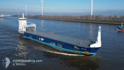
The vessel OCEANIC (IMO: 9624550, MMSI: 244918000) is a General Cargo that was built in 2012 ( 12 år gamle ). It's sailing under the flag of [NL] Netherlands.
In this page you can find informations about the vessels current position, last detected port calls, and current voyage information. If the vessels is not in coverage by AIS you will find the latest position.
The current position of OCEANIC is detected by our AIS receivers and we are not responsible for the reliability of the data. The last position was recorded while the vessel was in Coverage by the Ais receivers of our vessel tracking app.
The current draught of OCEANIC as reported by AIS is 4.2 meters
Weather
| Temperature | --- |
|---|---|
| Wind Speed | 11 knots |
| Direction | 54° NE |
| Pressure | 1005 hPa |
| Humidity | 60.8 % |
| Cloud Coverage | 100 % |
Featured Company
Last Port Calls
| Port | Arrival | Departure | Time In Port |
|---|---|---|---|
| 2024-04-14 09:36 | 2024-04-16 15:55 | 2 d | |
| 2024-03-24 09:24 | 2024-03-28 01:26 | 3 d | |
| 2024-03-22 08:27 | 2024-03-23 04:21 | 19 h | |
| 2024-03-19 17:38 | 2024-03-20 18:12 | 1 d | |
| 2024-03-05 21:33 | 2024-03-07 19:54 | 1 d | |
| 2024-02-29 14:36 | 2024-03-05 17:32 | 5 d | |
| 2024-02-26 18:28 | 2024-02-27 19:01 | 1 d | |
| 2024-02-20 12:44 | 2024-02-21 20:03 | 1 d | |
| 2024-02-18 07:33 | 2024-02-19 18:26 | 1 d | |
| 2024-02-13 04:33 | 2024-02-14 10:53 | 1 d |
Last Trips
| Origin | Departure | Destination | Arrival | Distance | |
|---|---|---|---|---|---|
| 2024-03-28 04:26 | 2024-04-14 11:36 | 4168.44 nm | |||
| 2024-03-23 07:21 | 2024-03-24 12:24 | 313.17 nm | |||
| 2024-03-20 21:12 | 2024-03-22 11:27 | 304.73 nm | |||
| 2024-03-07 20:54 | 2024-03-19 20:38 | 2722.57 nm | |||
| 2024-03-05 18:32 | 2024-03-05 22:33 | 38.67 nm | |||
| 2024-02-27 20:01 | 2024-02-29 15:36 | 223.33 nm | |||
| 2024-02-21 20:03 | 2024-02-26 19:28 | 787.06 nm | |||
| 2024-02-19 18:26 | 2024-02-20 12:44 | 68.44 nm | |||
| 2024-02-14 11:53 | 2024-02-18 07:33 | 854.59 nm | |||
| 2024-02-07 07:33 | 2024-02-13 05:33 | 1059.94 nm |
Events
| Tid | Hændelsen | Detaljer | Position / Dest | Info |
|---|---|---|---|---|
| 2024-04-17 17:34 | STOP Sejllads | 2.35 nm, North West of VENE BALTI |
59.48407 / 24.60271
EEVEB
|
Fart: 0.3 kn Kurs: 511° |
| 2024-04-17 17:22 | Status er ændret | At anchor Under way using engine |
59.48523 / 24.60356
EEVEB
|
Fart: 0.9 kn Kurs: 138° |
| 2024-04-17 16:09 | Status er ændret | Under way using engine Default |
59.49110 / 24.26030
EEVEB
|
Fart: 10 kn Kurs: 86° |
| 2024-04-17 15:49 | Status er ændret | Default Under way using engine |
59.48707 / 24.14620
EEVEB
|
Fart: 10.3 kn Kurs: 85.9° |
| 2024-04-17 14:48 | Status er ændret | Under way using engine Default |
59.47695 / 23.81471
EEVEB
|
Fart: 9.9 kn Kurs: 83° |
| 2024-04-17 14:48 | Indenfor Dækning |
59.47695 / 23.81471
Gulf of Finland
EEVEB
|
Fart: 10 kn Kurs: 86.8° |
|
| 2024-04-17 13:39 | Status er ændret | Default Under way using engine |
59.45606 / 23.43426
EEVEB
|
Fart: 10.1 kn Kurs: 85.1° |
| 2024-04-17 13:31 | Udenfor Dækning |
59.45425 / 23.39392
Gulf of Finland
EEVEB
|
Fart: 10.1 kn Kurs: 85.1° |
|
| 2024-04-17 13:04 | Fundet i havområde | Estonian part of the Gulf of Finland |
59.44932 / 23.24913
Gulf of Finland
EEVEB
|
Fart: 9.9 kn Kurs: 86.8° |
| 2024-04-17 12:30 | Ændre havområde | Estonian part of the Baltic Sea Finnish part of the Baltic Sea |
59.44420 / 23.05642
Baltic Sea
EEVEB
|
Fart: 10.3 kn Kurs: 86.4° |