
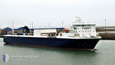
NORSTREAM
Ro-Ro Cargo
Current Trip
| Time Travelled | 2 h, 37 mins |
|---|---|
| Remaining Time | --- |
| Distance Travelled | 41.74 nm |
| Remaining Distance | --- |
| AVG Speed | 16.2 Knots |
| MAX Speed | 17.7 Knots |
| AVG Wind | 25.2 knots |
| MAX Wind | 27.9 knots |
| MIN Temp | 8.2°C / 46.76°F |
| MAX Temp | 9.7°C / 49.46°F |
| Dybgang | 6.3 m |
| Position Modtaget | 1 m siden |
Current Position
| Longitude | 2.20229° |
|---|---|
| Latitude | 51.59650° |
| Status | Under way using engine |
| Fart | 16.8 Knots |
| Kurs | 280.5° |
| Område | North Sea |
| Station | T-AIS |
| Position Modtaget | 1 m siden |
Info
Information
The current position of NORSTREAM is in North Sea with coordinates 51.59650° / 2.20229° as reported on 2024-04-18 23:57 by AIS to our vessel tracker app. The vessel's current speed is 16.8 Knots
The vessel NORSTREAM (IMO: 9186194, MMSI: 230653000) is a Ro-Ro Cargo that was built in 1999 ( 25 år gamle ). It's sailing under the flag of [FI] Finland.
In this page you can find informations about the vessels current position, last detected port calls, and current voyage information. If the vessels is not in coverage by AIS you will find the latest position.
The current position of NORSTREAM is detected by our AIS receivers and we are not responsible for the reliability of the data. The last position was recorded while the vessel was in Coverage by the Ais receivers of our vessel tracking app.
The current draught of NORSTREAM as reported by AIS is 6.3 meters
Weather
| Temperature | 9°C / 48.2°F |
|---|---|
| Wind Speed | 25 knots |
| Direction | 261° W |
| Pressure | 1017 hPa |
| Humidity | 77.3 % |
| Cloud Coverage | 100 % |
Featured Company
Last Port Calls
| Port | Arrival | Departure | Time In Port |
|---|---|---|---|
| 2024-04-18 16:18 | 2024-04-18 21:21 | 5 h | |
| 2024-04-17 16:13 | 2024-04-17 21:17 | 5 h | |
| 2024-04-16 16:19 | 2024-04-16 21:48 | 5 h | |
| 2024-04-15 16:23 | 2024-04-15 21:52 | 5 h | |
| 2024-04-14 16:20 | 2024-04-14 21:16 | 4 h | |
| 2024-04-13 08:00 | 2024-04-13 19:24 | 11 h | |
| 2024-04-12 04:21 | 2024-04-12 12:29 | 8 h | |
| 2024-04-10 04:17 | 2024-04-11 10:59 | 1 d | |
| 2024-04-09 04:20 | 2024-04-09 10:00 | 5 h | |
| 2024-04-08 04:14 | 2024-04-08 11:48 | 7 h |
Last Trips
| Origin | Departure | Destination | Arrival | Distance | |
|---|---|---|---|---|---|
| 2024-04-17 23:17 | 2024-04-18 18:18 | 228.02 nm | |||
| 2024-04-16 23:48 | 2024-04-17 18:13 | 227.66 nm | |||
| 2024-04-15 23:52 | 2024-04-16 18:19 | 226.24 nm | |||
| 2024-04-14 23:16 | 2024-04-15 18:23 | 228.42 nm | |||
| 2024-04-13 21:24 | 2024-04-14 18:20 | 227.59 nm | |||
| 2024-04-12 13:29 | 2024-04-13 10:00 | 265.10 nm | |||
| 2024-04-11 12:59 | 2024-04-12 05:21 | 262.28 nm | |||
| 2024-04-09 12:00 | 2024-04-10 06:17 | 224.12 nm | |||
| 2024-04-08 12:48 | 2024-04-09 06:20 | 263.80 nm | |||
| 2024-04-07 13:55 | 2024-04-08 05:14 | 261.39 nm |
Events
| Tid | Hændelsen | Detaljer | Position / Dest | Info |
|---|---|---|---|---|
| 2024-04-18 23:53 | Ændre havområde | United Kingdom part of the North Sea Belgian part of the North Sea |
51.59302 / 2.23147
North Sea
BEZEE<>GBTIL
|
Fart: 16.6 kn Kurs: 281.2° |
| 2024-04-18 21:21 | Afsejlet fra sidste havn |
|
51.36606 / 3.18732
BEZEE<>GBTIL
|
Fart: 14.2 kn Kurs: 320° |
| 2024-04-18 21:06 | START Sejllads |
51.33476 / 3.19506
[BE] ZEEBRUGGE
|
Fart: 4.4 kn Kurs: 13° |
|
| 2024-04-18 20:57 | Dybgangen er ændret | 6.3 5.5 |
51.33295 / 3.19353
[BE] ZEEBRUGGE
|
Fart: Kurs: 11° |
| 2024-04-18 20:56 | Status er ændret | Under way using engine Moored |
51.33295 / 3.19354
[BE] ZEEBRUGGE
|
Fart: Kurs: 11° |
| 2024-04-18 17:03 | ETA er ændret | 2024/04/19 05:00 2024/04/18 17:00 |
51.33297 / 3.19358
[BE] ZEEBRUGGE
|
Fart: Kurs: 12° |
| 2024-04-18 16:55 | Status er ændret | Moored Under way using engine |
51.33297 / 3.19355
[BE] ZEEBRUGGE
|
Fart: Kurs: 12° |
| 2024-04-18 16:47 | STOP Sejllads |
51.33302 / 3.19367
[BE] ZEEBRUGGE
|
Fart: 0.3 kn Kurs: 12° |
|
| 2024-04-18 16:18 | Skibe i havn |
|
51.36411 / 3.18952
[BE] ZEEBRUGGE
|
Fart: 14.7 kn Kurs: 135.3° |
| 2024-04-18 13:59 | Ændre havområde | Belgian part of the North Sea United Kingdom part of the North Sea |
51.60057 / 2.25160
North Sea
BEZEE<>GBTIL
|
Fart: 17.9 kn Kurs: 112.3° |