
NEVA-LEADER 1
General Cargo
Current Trip
| Time Travelled | 23 h, 11 mins |
|---|---|
| Remaining Time | --- |
| Distance Travelled | 91.99 nm |
| Remaining Distance | --- |
| AVG Speed | 7.8 Knots |
| MAX Speed | 10 Knots |
| AVG Wind | 14.4 knots |
| MAX Wind | 20.8 knots |
| MIN Temp | 11.9°C / 53.42°F |
| MAX Temp | 13.9°C / 57.02°F |
| Dybgang | 3.6 m |
| Position Modtaget | 2 m siden |
Current Position
| Longitude | 29.18197° |
|---|---|
| Latitude | 40.85987° |
| Status | At anchor |
| Fart | 0.3 Knots |
| Kurs | 260° |
| Område | Sea of Marmara |
| Station | T-AIS |
| Position Modtaget | 2 m siden |
Info
Information
The current position of NEVA-LEADER 1 is in Sea of Marmara with coordinates 40.85987° / 29.18197° as reported on 2024-04-20 10:34 by AIS to our vessel tracker app. The vessel's current speed is 0.3 Knots and is heading at the port of YEYSK. The estimated time of arrival as calculated by MyShipTracking vessel tracking app is 2024-04-25 12:00 LT
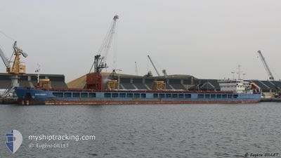
The vessel NEVA-LEADER 1 (IMO: 9598816, MMSI: 273351280) is a General Cargo that was built in 2012 ( 12 år gamle ). It's sailing under the flag of [RU] Russia.
In this page you can find informations about the vessels current position, last detected port calls, and current voyage information. If the vessels is not in coverage by AIS you will find the latest position.
The current position of NEVA-LEADER 1 is detected by our AIS receivers and we are not responsible for the reliability of the data. The last position was recorded while the vessel was in Coverage by the Ais receivers of our vessel tracking app.
The current draught of NEVA-LEADER 1 as reported by AIS is 3.6 meters
Weather
| Temperature | 12.7°C / 54.86°F |
|---|---|
| Wind Speed | 7 knots |
| Direction | 310° NW |
| Pressure | 1002.3 hPa |
| Humidity | 87.6 % |
| Cloud Coverage | 96 % |
Featured Company
Events
| Tid | Hændelsen | Detaljer | Position / Dest | Info |
|---|---|---|---|---|
| 2024-04-20 01:43 | STOP Sejllads | 1.78 nm, South West of KARTAL |
40.85903 / 29.17855
RU YEY
|
Fart: 0.3 kn Kurs: 56° |
| 2024-04-20 01:20 | Status er ændret | At anchor Under way using engine |
40.85863 / 29.17890
RU YEY
|
Fart: 0.6 kn Kurs: 60° |
| 2024-04-20 00:09 | Dybgangen er ændret | 3.6 4.2 |
40.84593 / 29.01860
RU YEY
|
Fart: 9.2 kn Kurs: 105.1° |
| 2024-04-19 23:00 | START Sejllads | 1.75 nm, South West of BAKIRKOY |
40.94668 / 28.86338
RU YEY
|
Fart: 3.1 kn Kurs: 157° |
| 2024-04-19 22:39 | Status er ændret | Under way using engine At anchor |
40.94905 / 28.86545
RU YEY
|
Fart: 0.1 kn Kurs: 37° |
| 2024-04-19 20:07 | STOP Sejllads | 1.56 nm, South of BAKIRKOY |
40.94878 / 28.86752
RU YEY
|
Fart: 0.2 kn Kurs: 331° |
| 2024-04-19 19:43 | Status er ændret | At anchor Under way using engine |
40.94980 / 28.86755
RU YEY
|
Fart: 0.8 kn Kurs: 315° |
| 2024-04-19 17:08 | Status er ændret | Under way using engine Default |
40.81865 / 28.51087
RU YEY
|
Fart: 8.6 kn Kurs: 84° |
| 2024-04-19 17:02 | Status er ændret | Default Under way using engine |
40.81747 / 28.49337
RU YEY
|
Fart: 8.5 kn Kurs: 84.2° |
| 2024-04-19 16:35 | Status er ændret | Under way using engine Default |
40.80887 / 28.40762
RU YEY
|
Fart: 8.7 kn Kurs: 86° |