
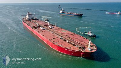
NAVE CONSTELLATION
Tanker D
Current Trip
| Time Travelled | 17 days |
|---|---|
| Remaining Time | --- |
| Distance Travelled | 3461.59 nm |
| Remaining Distance | 13.64 nm |
| AVG Speed | 10.1 Knots |
| MAX Speed | 15.4 Knots |
| AVG Wind | 12.6 knots |
| MAX Wind | 29 knots |
| MIN Temp | 4.2°C / 39.56°F |
| MAX Temp | 29.6°C / 85.28°F |
| Dybgang | 11 m |
| Position Modtaget | 1 m siden |
Current Position
| Longitude | 103.92181° |
|---|---|
| Latitude | 1.24313° |
| Status | At anchor |
| Fart | 0.1 Knots |
| Kurs | 264° |
| Område | Singapore Strait |
| Station | T-AIS |
| Position Modtaget | 1 m siden |
Info
Information
The current position of NAVE CONSTELLATION is in Singapore Strait with coordinates 1.24313° / 103.92181° as reported on 2024-04-16 05:13 by AIS to our vessel tracker app. The vessel's current speed is 0.1 Knots and is heading at the port of JURONG ISLAND. The estimated time of arrival as calculated by MyShipTracking vessel tracking app is 2024-04-16 01:30 LT
The vessel NAVE CONSTELLATION (IMO: 9515929, MMSI: 636020982) is a Tanker D It's sailing under the flag of [LR] Liberia.
In this page you can find informations about the vessels current position, last detected port calls, and current voyage information. If the vessels is not in coverage by AIS you will find the latest position.
The current position of NAVE CONSTELLATION is detected by our AIS receivers and we are not responsible for the reliability of the data. The last position was recorded while the vessel was in Coverage by the Ais receivers of our vessel tracking app.
The current draught of NAVE CONSTELLATION as reported by AIS is 11 meters
Weather
| Temperature | 29.9°C / 85.82°F |
|---|---|
| Wind Speed | 9 knots |
| Direction | 72° ENE |
| Pressure | 1009.2 hPa |
| Humidity | 69.6 % |
| Cloud Coverage | 100 % |
Featured Company
Last Port Calls
| Port | Arrival | Departure | Time In Port |
|---|---|---|---|
| 2024-03-28 00:00 | 2024-03-29 10:29 | 1 d | |
| 2024-02-29 13:38 | 2024-03-01 13:38 | 23 h |
Most Visited Ports (Last year)
| Port | Arrivals | |
|---|---|---|
| 1 | ||
| 1 | ||
| 1 | ||
| 1 | ||
| 1 | ||
| 1 |
Last Trips
| Origin | Departure | Destination | Arrival | Distance | |
|---|---|---|---|---|---|
| 2024-03-01 16:38 | 2024-03-28 08:00 | 6366.73 nm | |||
| 2024-01-31 09:22 | 2024-02-29 16:38 | 6570.00 nm |
Events
| Tid | Hændelsen | Detaljer | Position / Dest | Info |
|---|---|---|---|---|
| 2024-04-16 04:34 | Status er ændret | At anchor Under way using engine |
1.24290 / 103.92186
SG PEBGC
|
Fart: 0.1 kn Kurs: 271° |
| 2024-04-16 03:50 | Status er ændret | Under way using engine At anchor |
1.24357 / 103.92175
SG PEBGC
|
Fart: 0.1 kn Kurs: 248° |
| 2024-04-16 03:18 | Status er ændret | At anchor Default |
1.24357 / 103.92140
SG PEBGC
|
Fart: 0.2 kn Kurs: 266° |
| 2024-04-16 03:09 | Status er ændret | Default At anchor |
1.24298 / 103.92198
SG PEBGC
|
Fart: 0.4 kn Kurs: 272° |
| 2024-04-16 02:39 | Status er ændret | At anchor Under way using engine |
1.24326 / 103.92051
SG PEBGC
|
Fart: 0.4 kn Kurs: 230° |
| 2024-04-16 02:34 | STOP Sejllads | 4.06 nm, East of SINGAPORE |
1.24271 / 103.92042
SG PEBGC
|
Fart: 0.2 kn Kurs: 244° |
| 2024-04-16 00:22 | Ændre havområde | Singaporean part of the Singapore Strait Indonesian part of the Singapore Strait |
1.27147 / 104.05325
Singapore Strait
SG PEBGC
|
Fart: 4.6 kn Kurs: 269.6° |
| 2024-04-16 00:16 | Ændre havområde | Indonesian part of the Singapore Strait Malaysian part of the Singapore Strait |
1.27166 / 104.06090
Singapore Strait
SG PEBGC
|
Fart: 4.6 kn Kurs: 267.1° |
| 2024-04-15 23:34 | Status er ændret | Under way using engine Default |
1.27896 / 104.11666
SG PEBGC
|
Fart: 6 kn Kurs: 276° |
| 2024-04-15 23:31 | Status er ændret | Default Under way using engine |
1.27866 / 104.12135
SG PEBGC
|
Fart: 6.9 kn Kurs: 277.4° |