
MYGAS
Tanker
Current Trip
| Time Travelled | 1 day |
|---|---|
| Remaining Time | --- |
| Distance Travelled | 131.40 nm |
| Remaining Distance | --- |
| AVG Speed | 10.7 Knots |
| MAX Speed | 12.1 Knots |
| AVG Wind | 13.3 knots |
| MAX Wind | 22 knots |
| MIN Temp | 17.7°C / 63.86°F |
| MAX Temp | 22°C / 71.6°F |
| Dybgang | 7.7 m |
| Position Modtaget | 10 h, 39 m siden |
Current Position
| Longitude | -94.73981° |
|---|---|
| Latitude | 29.35282° |
| Status | At anchor |
| Fart | |
| Kurs | 114° |
| Område | Gulf of Mexico |
| Station | T-AIS |
| Position Modtaget | 10 h, 39 m siden |
Info
Information
The current position of MYGAS is in Gulf of Mexico with coordinates 29.35282° / -94.73981° as reported on 2024-04-23 00:04 by AIS to our vessel tracker app. The vessel's current speed is 0 Knots and is heading at the port of ANCHORAGE. The estimated time of arrival as calculated by MyShipTracking vessel tracking app is 2024-04-21 20:00 LT
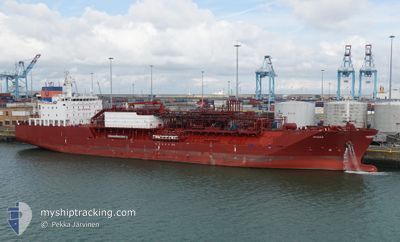
The vessel MYGAS (IMO: 9694397, MMSI: 305377000) is a Tanker It's sailing under the flag of [AG] Antigua Barbuda.
In this page you can find informations about the vessels current position, last detected port calls, and current voyage information. If the vessels is not in coverage by AIS you will find the latest position.
The current position of MYGAS is detected by our AIS receivers and we are not responsible for the reliability of the data. The last position was recorded while the vessel was in Coverage by the Ais receivers of our vessel tracking app.
The current draught of MYGAS as reported by AIS is 7.7 meters
Weather
| Temperature | 19.9°C / 67.82°F |
|---|---|
| Wind Speed | 10 knots |
| Direction | 128° SE |
| Pressure | 1019.1 hPa |
| Humidity | 58.9 % |
| Cloud Coverage | 7 % |
Featured Company
Events
| Tid | Hændelsen | Detaljer | Position / Dest | Info |
|---|---|---|---|---|
| 2024-04-23 00:50 | START Sejllads | 2.54 nm, South East of BOLIVAR |
29.35258 / -94.73753
ANCHORAGE
|
Fart: 3.3 kn Kurs: 150° |
| 2024-04-23 00:10 | Status er ændret | Default At anchor |
29.35274 / -94.73956
ANCHORAGE
|
Fart: Kurs: 114° |
| 2024-04-23 00:04 | Status er ændret | At anchor Default |
29.35282 / -94.73981
ANCHORAGE
|
Fart: Kurs: 116° |
| 2024-04-23 00:04 | Udenfor Dækning |
29.35282 / -94.73981
Gulf of Mexico
|
Fart: Kurs: 121.8° |
|
| 2024-04-22 23:46 | Indenfor Dækning |
29.35282 / -94.73981
Gulf of Mexico
|
Fart: Kurs: 121.8° |
|
| 2024-04-22 13:52 | Status er ændret | Default At anchor |
29.35232 / -94.74007
ANCHORAGE
|
Fart: Kurs: 74° |
| 2024-04-22 13:49 | Status er ændret | At anchor Default |
29.35226 / -94.74009
ANCHORAGE
|
Fart: Kurs: 76° |
| 2024-04-22 13:49 | Udenfor Dækning |
29.35226 / -94.74009
Gulf of Mexico
|
Fart: Kurs: 172.7° |
|
| 2024-04-22 13:04 | Status er ændret | Default At anchor |
29.35245 / -94.74001
ANCHORAGE
|
Fart: Kurs: 75° |
| 2024-04-22 12:58 | Status er ændret | At anchor Default |
29.35244 / -94.74001
ANCHORAGE
|
Fart: Kurs: 76° |