
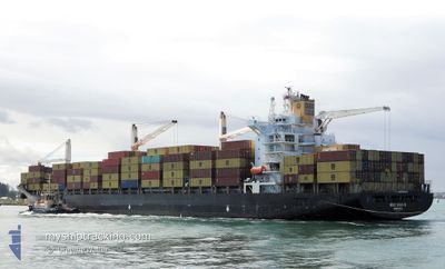
MSC STAR R
Container Ship
Current Trip
| Time Travelled | 1 day |
|---|---|
| Remaining Time | 2 days |
| Distance Travelled | 403.41 nm |
| Remaining Distance | 930.17 nm |
| AVG Speed | 15.7 Knots |
| MAX Speed | 17.4 Knots |
| AVG Wind | 5.8 knots |
| MAX Wind | 12 knots |
| MIN Temp | 14.4°C / 57.92°F |
| MAX Temp | 19.1°C / 66.38°F |
| Dybgang | 11.5 m |
| Position Modtaget | 23 h, 3 m siden |
Current Position
| Longitude | 174.80932° |
|---|---|
| Latitude | -35.67255° |
| Status | Under way using engine |
| Fart | 16.5 Knots |
| Kurs | 35.5° |
| Område | South Pacific Ocean |
| Station | T-AIS |
| Position Modtaget | 23 h, 3 m siden |
Info
Information
The current position of MSC STAR R is in South Pacific Ocean with coordinates -35.67255° / 174.80932° as reported on 2024-04-23 08:06 by AIS to our vessel tracker app. The vessel's current speed is 16.5 Knots and is heading at the port of BRISBANE. The estimated time of arrival as calculated by MyShipTracking vessel tracking app is 2024-04-26 15:01 LT
The vessel MSC STAR R (IMO: 9210050, MMSI: 636015031) is a Container Ship that was built in 2000 ( 24 år gamle ). It's sailing under the flag of [LR] Liberia.
In this page you can find informations about the vessels current position, last detected port calls, and current voyage information. If the vessels is not in coverage by AIS you will find the latest position.
The current position of MSC STAR R is detected by our AIS receivers and we are not responsible for the reliability of the data. The last position was recorded while the vessel was in Coverage by the Ais receivers of our vessel tracking app.
The current draught of MSC STAR R as reported by AIS is 11.5 meters
Weather
| Temperature | 19°C / 66.2°F |
|---|---|
| Wind Speed | 9 knots |
| Direction | 102° ESE |
| Pressure | 1018.2 hPa |
| Humidity | 67 % |
| Cloud Coverage | 100 % |
Featured Company
Last Port Calls
| Port | Arrival | Departure | Time In Port |
|---|---|---|---|
| 2024-04-22 19:07 | 2024-04-23 06:18 | 11 h | |
| 2024-04-20 16:33 | 2024-04-21 19:32 | 1 d | |
| 2024-04-18 09:44 | 2024-04-19 17:11 | 1 d | |
| 2024-04-14 01:09 | 2024-04-15 20:08 | 1 d | |
| 2024-04-07 05:41 | 2024-04-09 02:29 | 1 d | |
| 2024-04-04 10:04 | 2024-04-05 01:30 | 15 h | |
| 2024-03-30 15:21 | 2024-03-31 23:30 | 1 d | |
| 2024-03-21 04:44 | 2024-03-22 01:01 | 20 h | |
| 2024-03-18 04:05 | 2024-03-19 08:24 | 1 d | |
| 2024-03-12 11:47 | 2024-03-13 03:40 | 15 h |
Most Visited Ports (Last year)
| Port | Arrivals | |
|---|---|---|
| 14 | ||
| 10 | ||
| 3 | ||
| 3 | ||
| 3 | ||
| 3 |
Last Trips
| Origin | Departure | Destination | Arrival | Distance | |
|---|---|---|---|---|---|
| 2024-04-22 07:32 | 2024-04-23 07:07 | 185.18 nm | |||
| 2024-04-20 05:11 | 2024-04-21 04:33 | 295.68 nm | |||
| 2024-04-16 08:08 | 2024-04-18 21:44 | 661.78 nm | |||
| 2024-04-09 12:29 | 2024-04-14 13:09 | 1490.35 nm | |||
| 2024-04-05 12:00 | 2024-04-07 15:41 | 538.53 nm | |||
| 2024-04-01 07:30 | 2024-04-04 20:34 | 1385.89 nm | |||
| 2024-03-22 08:01 | 2024-03-30 23:21 | 1819.65 nm | |||
| 2024-03-19 16:24 | 2024-03-21 11:44 | 595.13 nm | |||
| 2024-03-13 11:40 | 2024-03-18 12:05 | 93.94 nm | |||
| 2024-02-26 15:59 | 2024-03-12 19:47 | 5267.81 nm |
Events
| Tid | Hændelsen | Detaljer | Position / Dest | Info |
|---|---|---|---|---|
| 2024-04-23 08:11 | Status er ændret | Default Under way using engine |
-35.65439 / 174.82527
NZMAP > AUBNE
|
Fart: 16.5 kn Kurs: 35.5° |
| 2024-04-23 08:06 | Status er ændret | Under way using engine Default |
-35.67255 / 174.80932
NZMAP > AUBNE
|
Fart: 16.5 kn Kurs: 35° |
| 2024-04-23 08:06 | Udenfor Dækning |
-35.67255 / 174.80932
South Pacific Ocean
NZMAP > AUBNE
|
Fart: 16.5 kn Kurs: 35.5° |
|
| 2024-04-23 07:59 | Status er ændret | Default Under way using engine |
-35.69893 / 174.78619
NZMAP > AUBNE
|
Fart: 16.2 kn Kurs: 35.3° |
| 2024-04-23 06:18 | Afsejlet fra sidste havn |
|
-35.83500 / 174.50339
NZMAP > AUBNE
|
Fart: 8.5 kn Kurs: 113° |
| 2024-04-23 06:12 | START Sejllads |
-35.83287 / 174.49105
[NZ] MARSDEN POINT
|
Fart: 3.3 kn Kurs: 100° |
|
| 2024-04-23 05:53 | Status er ændret | Under way using engine Moored |
-35.83260 / 174.48728
[NZ] MARSDEN POINT
|
Fart: Kurs: 111° |
| 2024-04-23 05:35 | Dybgangen er ændret | 11.5 11.3 |
-35.83259 / 174.48728
[NZ] MARSDEN POINT
|
Fart: Kurs: 111° |
| 2024-04-23 05:35 | Destination er ændret | NZMAP > AUBNE NZTRG > NZMAP |
-35.83259 / 174.48728
[NZ] MARSDEN POINT
|
Fart: Kurs: 111° |
| 2024-04-23 05:35 | ETA er ændret | 2024/04/26 20:15 2024/04/22 08:00 |
-35.83259 / 174.48728
[NZ] MARSDEN POINT
|
Fart: Kurs: 111° |