
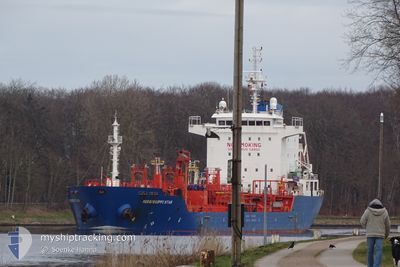
MISSISSIPPI STAR
Oil/Chemical Tanker
Current Trip
| Time Travelled | 11 h, 20 mins |
|---|---|
| Remaining Time | --- |
| Distance Travelled | 120.16 nm |
| Remaining Distance | --- |
| AVG Speed | 10.4 Knots |
| MAX Speed | 11.4 Knots |
| AVG Wind | 12.1 knots |
| MAX Wind | 16 knots |
| MIN Temp | 24.3°C / 75.74°F |
| MAX Temp | 28°C / 82.4°F |
| Dybgang | 6.7 m |
| Position Modtaget | 2024-03-15 09:19 |
Current Position
| Longitude | -94.69912° |
|---|---|
| Latitude | 29.34230° |
| Status | Under way using engine |
| Fart | 13.7 Knots |
| Kurs | 104.8° |
| Område | Gulf of Mexico |
| Station | T-AIS |
| Position Modtaget | 2024-03-15 09:19 |
Info
Information
The current position of MISSISSIPPI STAR is in Gulf of Mexico with coordinates 29.34230° / -94.69912° as reported on 2024-03-15 09:19 by AIS to our vessel tracker app. The vessel's current speed is 13.7 Knots and is heading at the port of COATZACOALCOS.
The vessel MISSISSIPPI STAR (IMO: 9527623, MMSI: 248621000) is a Oil/Chemical Tanker that was built in 2010 ( 14 år gamle ). It's sailing under the flag of [MT] Malta.
In this page you can find informations about the vessels current position, last detected port calls, and current voyage information. If the vessels is not in coverage by AIS you will find the latest position.
The current position of MISSISSIPPI STAR is detected by our AIS receivers and we are not responsible for the reliability of the data. The last position was recorded while the vessel was in Coverage by the Ais receivers of our vessel tracking app.
The current draught of MISSISSIPPI STAR as reported by AIS is 6.7 meters
Weather
| Temperature | 27.9°C / 82.22°F |
|---|---|
| Wind Speed | 14 knots |
| Direction | 59° ENE |
| Pressure | 1013.4 hPa |
| Humidity | 76.1 % |
| Cloud Coverage | 3 % |
Featured Company
Last Port Calls
| Port | Arrival | Departure | Time In Port |
|---|---|---|---|
| 2024-04-21 14:34 | 2024-04-24 12:34 | 2 d | |
| 2024-04-14 18:13 | 2024-04-18 15:55 | 3 d | |
| 2024-04-13 22:16 | 2024-04-13 22:28 | 12 m | |
| 2024-04-13 12:48 | 2024-04-13 12:56 | 8 m | |
| 2024-04-06 22:37 | 2024-04-08 21:07 | 1 d | |
| 2024-03-26 14:54 | 2024-03-30 22:57 | 4 d | |
| 2024-03-18 17:08 | 2024-03-21 06:34 | 2 d | |
| 2024-03-11 02:07 | 2024-03-15 07:44 | 4 d | |
| 2024-03-04 06:46 | |||
| 2024-02-27 20:53 | 2024-02-29 12:47 | 1 d |
Most Visited Ports (Last year)
| Port | Arrivals | |
|---|---|---|
| 8 | ||
| 4 | ||
| 4 | ||
| 3 | ||
| 3 | ||
| 3 |
Last Trips
| Origin | Departure | Destination | Arrival | Distance | |
|---|---|---|---|---|---|
| 2024-04-18 10:55 | 2024-04-21 08:34 | 712.16 nm | |||
| 2024-04-13 17:28 | 2024-04-14 13:13 | 45.73 nm | |||
| 2024-04-13 07:56 | 2024-04-13 17:16 | 5.92 nm | |||
| 2024-04-08 16:07 | 2024-04-13 07:48 | 1179.92 nm | |||
| 2024-03-30 17:57 | 2024-04-06 16:37 | 1174.29 nm | |||
| 2024-03-21 00:34 | 2024-03-26 09:54 | 1167.78 nm | |||
| 2024-03-15 02:44 | 2024-03-18 11:08 | 697.50 nm | |||
| 2024-02-29 07:47 | 2024-03-04 00:46 | 672.21 nm | |||
| 2024-02-23 17:33 | 2024-02-27 15:53 | 11.28 nm | |||
| 2024-02-14 23:45 | 2024-02-19 16:41 | 1156.94 nm |
Events
| Tid | Hændelsen | Detaljer | Position / Dest | Info |
|---|---|---|---|---|
| 2024-04-24 12:34 | Afsejlet fra sidste havn |
|
16.50217 / -88.39986
US HOU >> MX COA
|
Fart: 5.6 kn Kurs: 155° |
| 2024-04-24 12:30 | START Sejllads |
16.50906 / -88.40242
[BZ] BIG CREEK
|
Fart: 5.6 kn Kurs: 155° |
|
| 2024-04-21 15:15 | STOP Sejllads |
16.51333 / -88.40166
[BZ] BIG CREEK
|
Fart: Kurs: -1° |
|
| 2024-04-21 14:34 | Skibe i havn |
|
16.50541 / -88.40105
[BZ] BIG CREEK
|
Fart: 9.6 kn Kurs: 344° |
| 2024-04-21 12:50 | START Sejllads | 9.32 nm, South of HARVEST CAYE |
16.31848 / -88.40618
US HOU >> MX COA
|
Fart: 5.3 kn Kurs: 295° |
| 2024-04-21 03:02 | STOP Sejllads | 9.53 nm, South of HARVEST CAYE |
16.31508 / -88.40226
US HOU >> MX COA
|
Fart: 0.3 kn Kurs: 77° |
| 2024-04-18 16:02 | START Sejllads | 0.75 nm, South East of ESQUIVEL |
17.88159 / -77.12001
US HOU >> MX COA
|
Fart: 7 kn Kurs: 120° |
| 2024-04-18 15:55 | Afsejlet fra sidste havn |
|
17.88159 / -77.12001
US HOU >> MX COA
|
Fart: Kurs: 145° |