
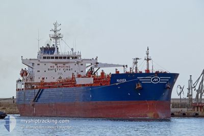
MARVEA
Oil/Chemical Tanker
Current Trip
| Time Travelled | 8 days |
|---|---|
| Remaining Time | --- |
| Distance Travelled | 1607.21 nm |
| Remaining Distance | --- |
| AVG Speed | 11.4 Knots |
| MAX Speed | 15.7 Knots |
| AVG Wind | 12.1 knots |
| MAX Wind | 31 knots |
| MIN Temp | 8.5°C / 47.3°F |
| MAX Temp | 23.7°C / 74.66°F |
| Dybgang | 9.4 m |
| Position Modtaget | 1 d siden |
Current Position
| Longitude | 14.82413° |
|---|---|
| Latitude | 36.15628° |
| Status | Under way using engine |
| Fart | 12.4 Knots |
| Kurs | 113° |
| Område | Mediterranean Sea - Eastern Basin |
| Station | T-AIS |
| Position Modtaget | 1 d siden |
Info
Information
The current position of MARVEA is in Mediterranean Sea - Eastern Basin with coordinates 36.15628° / 14.82413° as reported on 2024-04-24 09:59 by AIS to our vessel tracker app. The vessel's current speed is 12.4 Knots and is heading at the port of VASILIKO. The estimated time of arrival as calculated by MyShipTracking vessel tracking app is 2024-04-27 16:00 LT
The vessel MARVEA (IMO: 9301897, MMSI: 256210000) is a Oil/Chemical Tanker that was built in 2006 ( 18 år gamle ). It's sailing under the flag of [MT] Malta.
In this page you can find informations about the vessels current position, last detected port calls, and current voyage information. If the vessels is not in coverage by AIS you will find the latest position.
The current position of MARVEA is detected by our AIS receivers and we are not responsible for the reliability of the data. The last position was recorded while the vessel was in Coverage by the Ais receivers of our vessel tracking app.
The current draught of MARVEA as reported by AIS is 9.4 meters
Weather
| Temperature | 15.8°C / 60.44°F |
|---|---|
| Wind Speed | 15 knots |
| Direction | 300° WNW |
| Pressure | 1012.7 hPa |
| Humidity | 62.3 % |
| Cloud Coverage | --- |
Featured Company
Last Port Calls
| Port | Arrival | Departure | Time In Port |
|---|---|---|---|
| 2024-04-15 11:42 | 2024-04-17 11:00 | 1 d | |
| 2024-04-03 08:25 | 2024-04-05 02:08 | 1 d | |
| 2024-03-24 20:27 | 2024-03-25 23:52 | 1 d | |
| 2024-03-18 18:22 | 2024-03-21 01:49 | 2 d | |
| 2024-02-29 17:55 | 2024-03-03 04:29 | 2 d | |
| 2024-02-23 08:30 | 2024-02-24 13:55 | 1 d | |
| 2024-02-20 09:57 | 2024-02-20 12:43 | 2 h | |
| 2024-02-04 19:58 |
Last Trips
| Origin | Departure | Destination | Arrival | Distance | |
|---|---|---|---|---|---|
| 2024-04-05 03:08 | 2024-04-15 14:42 | 2570.45 nm | |||
| 2024-03-25 23:52 | 2024-04-03 09:25 | 839.83 nm | |||
| 2024-03-21 02:49 | 2024-03-24 20:27 | 1180.71 nm | |||
| 2024-03-03 05:29 | 2024-03-18 19:22 | 4042.39 nm | |||
| 2024-02-24 14:55 | 2024-02-29 18:55 | 720.91 nm | |||
| 2024-02-20 13:43 | 2024-02-23 09:30 | 143.36 nm | |||
| 2024-02-04 20:58 | 2024-02-20 10:57 | 2270.87 nm |
Events
| Tid | Hændelsen | Detaljer | Position / Dest | Info |
|---|---|---|---|---|
| 2024-04-24 10:03 | Status er ændret | Default Under way using engine |
36.15073 / 14.83982
VASILIKO
|
Fart: 12.4 kn Kurs: 113° |
| 2024-04-24 09:59 | Udenfor Dækning |
36.15628 / 14.82413
Mediterranean Sea - Eastern Basin
VASILIKO
|
Fart: 12.4 kn Kurs: 113° |
|
| 2024-04-24 06:44 | Destination er ændret | VASILIKO BEANR |
36.41282 / 14.10107
VASILIKO
|
Fart: 11.6 kn Kurs: 117° |
| 2024-04-24 06:44 | ETA er ændret | 2024/04/27 16:00 2024/04/30 18:00 |
36.41282 / 14.10107
VASILIKO
|
Fart: 11.6 kn Kurs: 117° |
| 2024-04-24 06:36 | Status er ændret | Under way using engine Default |
36.42558 / 14.07135
BEANR
|
Fart: 11.7 kn Kurs: 118° |
| 2024-04-24 06:21 | Indenfor Dækning |
36.42373 / 14.07557
Mediterranean Sea - Eastern Basin
BEANR
|
Fart: 11.8 kn Kurs: 118° |
|
| 2024-04-22 21:06 | Status er ændret | Default Under way using engine |
36.44960 / 14.03543
BEANR
|
Fart: 11.7 kn Kurs: 293° |
| 2024-04-22 20:57 | Udenfor Dækning |
36.43893 / 14.06687
Mediterranean Sea - Eastern Basin
BEANR
|
Fart: 11.7 kn Kurs: 293° |
|
| 2024-04-22 18:02 | Ændre havområde | Maltese part of the Mediterranean Sea - Eastern Basin Italian part of the Mediterranean Sea - Eastern Basin |
36.26678 / 14.75487
Mediterranean Sea - Eastern Basin
BEANR
|
Fart: 11.8 kn Kurs: 274° |
| 2024-04-22 18:02 | Status er ændret | Under way using engine Default |
36.26678 / 14.75487
BEANR
|
Fart: 11.7 kn Kurs: 274° |