
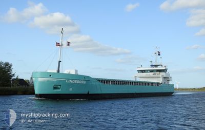
LINDEBORG
General Cargo
Current Trip
| Time Travelled | 1 day |
|---|---|
| Remaining Time | --- |
| Distance Travelled | 240.12 nm |
| Remaining Distance | --- |
| AVG Speed | 6.7 Knots |
| MAX Speed | 11 Knots |
| AVG Wind | 13.6 knots |
| MAX Wind | 25.9 knots |
| MIN Temp | 1.8°C / 35.24°F |
| MAX Temp | 8.2°C / 46.76°F |
| Dybgang | 4.1 m |
| Position Modtaget | 1 m siden |
Current Position
| Longitude | 9.80776° |
|---|---|
| Latitude | 55.23689° |
| Status | Under way using engine |
| Fart | 4.9 Knots |
| Kurs | 323° |
| Område | Kattegat |
| Station | T-AIS |
| Position Modtaget | 1 m siden |
Info
Information
The current position of LINDEBORG is in Kattegat with coordinates 55.23689° / 9.80776° as reported on 2024-04-20 00:20 by AIS to our vessel tracker app. The vessel's current speed is 4.9 Knots and is heading at the port of VEJLE. The estimated time of arrival as calculated by MyShipTracking vessel tracking app is 2024-04-20 10:00 LT
The vessel LINDEBORG (IMO: 9279068, MMSI: 246499000) is a General Cargo that was built in 2005 ( 19 år gamle ). It's sailing under the flag of [NL] Netherlands.
In this page you can find informations about the vessels current position, last detected port calls, and current voyage information. If the vessels is not in coverage by AIS you will find the latest position.
The current position of LINDEBORG is detected by our AIS receivers and we are not responsible for the reliability of the data. The last position was recorded while the vessel was in Coverage by the Ais receivers of our vessel tracking app.
The current draught of LINDEBORG as reported by AIS is 4.1 meters
Weather
| Temperature | 4.1°C / 39.38°F |
|---|---|
| Wind Speed | 12 knots |
| Direction | 5° N |
| Pressure | 1011.3 hPa |
| Humidity | 79.3 % |
| Cloud Coverage | 69 % |
Featured Company
Last Port Calls
| Port | Arrival | Departure | Time In Port |
|---|---|---|---|
| 2024-04-17 11:57 | 2024-04-18 11:08 | 23 h | |
| 2024-04-12 15:45 | 2024-04-12 19:45 | 3 h | |
| 2024-04-11 01:40 | 2024-04-11 23:02 | 21 h | |
| 2024-04-01 19:32 | 2024-04-09 01:40 | 7 d | |
| 2024-03-22 12:15 | 2024-03-27 16:59 | 5 d | |
| 2024-03-13 08:16 | 2024-03-14 15:23 | 1 d | |
| 2024-03-10 13:12 | 2024-03-12 14:07 | 2 d | |
| 2024-03-04 04:54 | 2024-03-05 04:18 | 23 h | |
| 2024-02-27 14:06 | 2024-02-28 11:18 | 21 h | |
| 2024-02-25 17:37 | 2024-02-26 19:05 | 1 d |
Last Trips
| Origin | Departure | Destination | Arrival | Distance | |
|---|---|---|---|---|---|
| 2024-04-12 21:45 | 2024-04-17 13:57 | 504.63 nm | |||
| 2024-04-12 00:02 | 2024-04-12 17:45 | 185.77 nm | |||
| 2024-04-09 02:40 | 2024-04-11 02:40 | 411.41 nm | |||
| 2024-03-27 18:59 | 2024-04-01 20:32 | 1085.25 nm | |||
| 2024-03-14 16:23 | 2024-03-22 14:15 | 1165.07 nm | |||
| 2024-03-12 14:07 | 2024-03-13 09:16 | 141.61 nm | |||
| 2024-03-05 04:18 | 2024-03-10 13:12 | 792.00 nm | |||
| 2024-02-28 12:18 | 2024-03-04 04:54 | 927.91 nm | |||
| 2024-02-26 20:05 | 2024-02-27 15:06 | 175.29 nm | |||
| 2024-02-23 15:02 | 2024-02-25 18:37 | 414.21 nm |
Events
| Tid | Hændelsen | Detaljer | Position / Dest | Info |
|---|---|---|---|---|
| 2024-04-19 18:23 | Ændre havområde | Danish part of the Kattegat Danish part of the Baltic Sea |
54.81373 / 10.30555
Kattegat
VEJLE
|
Fart: 5.6 kn Kurs: 303.3° |
| 2024-04-19 14:32 | Fundet i havområde | Danish part of the Baltic Sea |
54.63905 / 10.91545
Baltic Sea
VEJLE
|
Fart: 7.4 kn Kurs: 284.1° |
| 2024-04-19 12:44 | Ændre havområde | German part of the Baltic Sea Danish part of the Baltic Sea |
54.58441 / 11.26478
Baltic Sea
VEJLE
|
Fart: 7.1 kn Kurs: 288.2° |
| 2024-04-19 01:53 | Fundet i havområde | Danish part of the Baltic Sea |
54.83294 / 12.93102
Baltic Sea
VEJLE
|
Fart: 6.1 kn Kurs: 252° |
| 2024-04-18 20:35 | Ændre havområde | German part of the Baltic Sea Swedish part of the Baltic Sea |
55.01562 / 13.79414
Baltic Sea
VEJLE
|
Fart: 6.3 kn Kurs: 250.3° |
| 2024-04-18 11:08 | Afsejlet fra sidste havn |
|
56.02124 / 14.57660
VEJLE
|
Fart: 6.9 kn Kurs: 204° |
| 2024-04-18 11:02 | START Sejllads |
56.03126 / 14.58028
[SE] SOLVESBORG
|
Fart: 4.2 kn Kurs: 166° |
|
| 2024-04-18 10:55 | Dybgangen er ændret | 4.1 5.5 |
56.03319 / 14.57885
[SE] SOLVESBORG
|
Fart: Kurs: 208° |
| 2024-04-18 10:55 | ETA er ændret | 2024/04/20 10:00 2024/04/17 14:00 |
56.03319 / 14.57885
[SE] SOLVESBORG
|
Fart: Kurs: 208° |
| 2024-04-18 10:25 | Destination er ændret | VEJLE SOLVESBORG |
56.03325 / 14.57892
[SE] SOLVESBORG
|
Fart: Kurs: 208° |