
LE GB SHAW
Not available
Current Trip
MILITARY OPS
| Time Travelled | 16 h, 37 mins |
|---|---|
| Remaining Time | --- |
| Distance Travelled | 32.25 nm |
| Remaining Distance | --- |
| AVG Speed | 8.7 Knots |
| MAX Speed | 18.7 Knots |
| AVG Wind | 10.7 knots |
| MAX Wind | 11.3 knots |
| MIN Temp | 15.1°C / 59.18°F |
| MAX Temp | 15.2°C / 59.36°F |
| Dybgang | 0 m |
| Position Modtaget | 13 h, 19 m siden |
Current Position
| Longitude | -8.38421° |
|---|---|
| Latitude | 51.63914° |
| Status | Under way using engine |
| Fart | 14.3 Knots |
| Kurs | 230.9° |
| Område | Celtic Sea |
| Station | T-AIS |
| Position Modtaget | 13 h, 19 m siden |
Info
Information
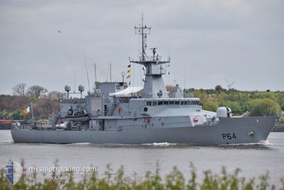
The current position of LE GB SHAW is in Celtic Sea with coordinates 51.63914° / -8.38421° as reported on 2024-04-22 17:10 by AIS to our vessel tracker app. The vessel's current speed is 14.3 Knots
The vessel LE GB SHAW (IMO: 9814519, MMSI: 250004884) is a Not available It's sailing under the flag of [IE] Ireland.
In this page you can find informations about the vessels current position, last detected port calls, and current voyage information. If the vessels is not in coverage by AIS you will find the latest position.
The current position of LE GB SHAW is detected by our AIS receivers and we are not responsible for the reliability of the data. The last position was recorded while the vessel was in Coverage by the Ais receivers of our vessel tracking app.
Weather
| Temperature | 16.2°C / 61.16°F |
|---|---|
| Wind Speed | 10 knots |
| Direction | 343° NNW |
| Pressure | 1028.8 hPa |
| Humidity | 72.6 % |
| Cloud Coverage | 72 % |
Featured Company
Last Port Calls
Most Visited Ports (Last year)
| Port | Arrivals | |
|---|---|---|
| 22 | ||
| 3 | ||
| 2 | ||
| 1 | ||
| 1 |
Last Trips
| Origin | Departure | Destination | Arrival | Distance | |
|---|---|---|---|---|---|
| 2024-03-22 11:16 | 2024-03-22 11:18 | 0.25 nm | |||
| 2024-03-18 09:52 | 2024-03-22 11:06 | 194.71 nm | |||
| 2024-03-13 15:28 | 2024-03-16 08:13 | 192.13 nm | |||
| 2024-03-13 15:16 | 2024-03-13 15:20 | 0.67 nm | |||
| 2024-03-12 15:05 | 2024-03-12 21:11 | 13.18 nm |
Events
| Tid | Hændelsen | Detaljer | Position / Dest | Info |
|---|---|---|---|---|
| 2024-04-22 17:10 | Udenfor Dækning |
51.63914 / -8.38421
Celtic Sea
|
Fart: 14.3 kn Kurs: 230.9° |
|
| 2024-04-22 16:12 | START Sejllads | 0.79 nm, North West of WHITEGATE |
51.83867 / -8.26199
MILITARY OPS
|
Fart: 6.2 kn Kurs: 199.7° |
| 2024-04-22 16:09 | STOP Sejllads | 0.83 nm, North West of WHITEGATE |
51.84026 / -8.26029
MILITARY OPS
|
Fart: 0.3 kn Kurs: 219° |
| 2024-04-22 13:52 | Afsejlet fra sidste havn |
|
51.84421 / -8.26116
MILITARY OPS
|
Fart: 10.9 kn Kurs: 158° |
| 2024-04-22 13:45 | Indenfor Dækning |
51.84861 / -8.28474
Celtic Sea
[IE] CORK
|
Fart: 9.6 kn Kurs: 78° |
|
| 2024-04-22 09:24 | Udenfor Dækning |
51.84292 / -8.30598
Celtic Sea
[IE] CORK
|
Fart: Kurs: 77.7° |
|
| 2024-04-22 09:20 | STOP Sejllads |
51.84289 / -8.30622
[IE] CORK
|
Fart: 0.2 kn Kurs: 81° |
|
| 2024-04-22 09:04 | Indenfor Dækning |
51.84097 / -8.31288
Celtic Sea
[IE] CORK
|
Fart: 3.8 kn Kurs: 234.8° |