
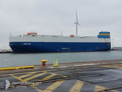
LAKE KIVU
Vehicles Carrier
Current Trip
| Time Travelled | 1 day |
|---|---|
| Remaining Time | 2 days |
| Distance Travelled | 591.37 nm |
| Remaining Distance | 753.33 nm |
| AVG Speed | 14.8 Knots |
| MAX Speed | 19.1 Knots |
| AVG Wind | 9.8 knots |
| MAX Wind | 20.1 knots |
| MIN Temp | 3.7°C / 38.66°F |
| MAX Temp | 12.2°C / 53.96°F |
| Dybgang | 8.4 m |
| Position Modtaget | 13 h, 37 m siden |
Current Position
| Longitude | -6.05402° |
|---|---|
| Latitude | 48.56660° |
| Status | Under way using engine |
| Fart | 14.3 Knots |
| Kurs | 206° |
| Område | Celtic Sea |
| Station | T-AIS |
| Position Modtaget | 13 h, 37 m siden |
Info
Information
The current position of LAKE KIVU is in Celtic Sea with coordinates 48.56660° / -6.05402° as reported on 2024-04-24 01:26 by AIS to our vessel tracker app. The vessel's current speed is 14.3 Knots and is heading at the port of TANGER MED. The estimated time of arrival as calculated by MyShipTracking vessel tracking app is 2024-04-26 16:14 LT
The vessel LAKE KIVU (IMO: 9308792, MMSI: 636015993) is a Vehicles Carrier that was built in 2006 ( 18 år gamle ). It's sailing under the flag of [LR] Liberia.
In this page you can find informations about the vessels current position, last detected port calls, and current voyage information. If the vessels is not in coverage by AIS you will find the latest position.
The current position of LAKE KIVU is detected by our AIS receivers and we are not responsible for the reliability of the data. The last position was recorded while the vessel was in Coverage by the Ais receivers of our vessel tracking app.
The current draught of LAKE KIVU as reported by AIS is 8.4 meters
Weather
| Temperature | 12°C / 53.6°F |
|---|---|
| Wind Speed | 13 knots |
| Direction | 326° NW |
| Pressure | 1021.3 hPa |
| Humidity | 78.5 % |
| Cloud Coverage | 100 % |
Featured Company
Last Port Calls
| Port | Arrival | Departure | Time In Port |
|---|---|---|---|
| 2024-04-21 11:12 | 2024-04-22 21:59 | 1 d | |
| 2024-04-19 10:44 | 2024-04-20 14:37 | 1 d | |
| 2024-04-16 10:19 | 2024-04-16 18:15 | 7 h | |
| 2024-04-13 09:17 | 2024-04-14 20:42 | 1 d | |
| 2024-04-03 12:09 | 2024-04-04 21:46 | 1 d | |
| 2024-04-01 08:25 | 2024-04-02 13:23 | 1 d | |
| 2024-03-26 00:39 | 2024-03-28 03:38 | 2 d | |
| 2024-03-20 11:09 | 2024-03-22 04:45 | 1 d | |
| 2024-03-18 08:33 | 2024-03-19 14:27 | 1 d | |
| 2024-03-12 15:01 | 2024-03-14 23:03 | 2 d |
Most Visited Ports (Last year)
| Port | Arrivals | |
|---|---|---|
| 19 | ||
| 18 | ||
| 18 | ||
| 17 | ||
| 5 | ||
| 5 |
Last Trips
| Origin | Departure | Destination | Arrival | Distance | |
|---|---|---|---|---|---|
| 2024-04-20 16:37 | 2024-04-21 13:12 | 201.38 nm | |||
| 2024-04-16 20:15 | 2024-04-19 12:44 | 717.92 nm | |||
| 2024-04-14 21:42 | 2024-04-16 12:19 | 538.25 nm | |||
| 2024-04-04 23:46 | 2024-04-13 09:17 | 2055.37 nm | |||
| 2024-04-02 15:23 | 2024-04-03 14:09 | 203.11 nm | |||
| 2024-03-28 03:38 | 2024-04-01 10:25 | 1242.73 nm | |||
| 2024-03-22 05:45 | 2024-03-26 00:39 | 1401.27 nm | |||
| 2024-03-19 15:27 | 2024-03-20 12:09 | 203.22 nm | |||
| 2024-03-14 23:03 | 2024-03-18 09:33 | 1210.18 nm | |||
| 2024-03-06 04:48 | 2024-03-12 15:01 | 1499.79 nm |
Events
| Tid | Hændelsen | Detaljer | Position / Dest | Info |
|---|---|---|---|---|
| 2024-04-24 01:39 | Status er ændret | Default Under way using engine |
48.51772 / -6.09055
MA PTM
|
Fart: 14.3 kn Kurs: 206° |
| 2024-04-24 01:26 | Udenfor Dækning |
48.56660 / -6.05402
Celtic Sea
MA PTM
|
Fart: 14.3 kn Kurs: 206° |
|
| 2024-04-24 01:25 | Status er ændret | Under way using engine Default |
48.56867 / -6.05245
MA PTM
|
Fart: 14.6 kn Kurs: 208° |
| 2024-04-24 01:09 | Indenfor Dækning |
48.56683 / -6.05383
Celtic Sea
MA PTM
|
Fart: 14.3 kn Kurs: 206° |
|
| 2024-04-24 00:09 | Status er ændret | Default Under way using engine |
48.84440 / -5.82302
MA PTM
|
Fart: 15.8 kn Kurs: 221° |
| 2024-04-24 00:05 | Status er ændret | Under way using engine Default |
48.85757 / -5.80778
MA PTM
|
Fart: 16 kn Kurs: 220° |
| 2024-04-24 00:05 | Udenfor Dækning |
48.85757 / -5.80778
Celtic Sea
MA PTM
|
Fart: 15.8 kn Kurs: 221° |
|
| 2024-04-24 00:05 | Ændre havområde | French part of the Celtic Sea French part of the English Channel |
48.85757 / -5.80778
Celtic Sea
MA PTM
|
Fart: 15.8 kn Kurs: 221° |
| 2024-04-23 23:48 | Indenfor Dækning |
48.85757 / -5.80778
Celtic Sea
MA PTM
|
Fart: 15.8 kn Kurs: 221° |
|
| 2024-04-23 20:39 | Udenfor Dækning |
49.36923 / -4.59128
English Channel
MA PTM
|
Fart: 16.3 kn Kurs: 241° |