
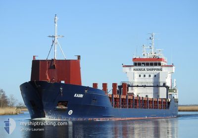
KAURI
General Cargo
Current Trip
FI KNT
| Time Travelled | 19 h, 29 mins |
|---|---|
| Remaining Time | --- |
| Distance Travelled | 222.41 nm |
| Remaining Distance | --- |
| AVG Speed | 10.8 Knots |
| MAX Speed | 12.3 Knots |
| AVG Wind | 10.3 knots |
| MAX Wind | 13.9 knots |
| MIN Temp | 2.9°C / 37.22°F |
| MAX Temp | 5.1°C / 41.18°F |
| Dybgang | 6.1 m |
| Position Modtaget | 3 h, 47 m siden |
Current Position
| Longitude | 16.36762° |
|---|---|
| Latitude | 55.92275° |
| Status | Under way using engine |
| Fart | 11.7 Knots |
| Kurs | 54.9° |
| Område | Baltic Sea |
| Station | T-AIS |
| Position Modtaget | 3 h, 47 m siden |
Info
Information
The current position of KAURI is in Baltic Sea with coordinates 55.92275° / 16.36762° as reported on 2024-04-25 12:48 by AIS to our vessel tracker app. The vessel's current speed is 11.7 Knots
The vessel KAURI (IMO: 9173226, MMSI: 305633000) is a General Cargo that was built in 1998 ( 26 år gamle ). It's sailing under the flag of [AG] Antigua Barbuda.
In this page you can find informations about the vessels current position, last detected port calls, and current voyage information. If the vessels is not in coverage by AIS you will find the latest position.
The current position of KAURI is detected by our AIS receivers and we are not responsible for the reliability of the data. The last position was recorded while the vessel was in Coverage by the Ais receivers of our vessel tracking app.
The current draught of KAURI as reported by AIS is 6.1 meters
Weather
| Temperature | 3.3°C / 37.94°F |
|---|---|
| Wind Speed | 4 knots |
| Direction | 71° ENE |
| Pressure | 1006.4 hPa |
| Humidity | 78.6 % |
| Cloud Coverage | 35 % |
Featured Company
Last Port Calls
| Port | Arrival | Departure | Time In Port |
|---|---|---|---|
| 2024-04-22 12:55 | 2024-04-24 21:06 | 2 d | |
| 2024-04-21 16:11 | 2024-04-21 16:14 | 3 m | |
| 2024-04-20 19:39 | 2024-04-20 20:02 | 23 m | |
| 2024-04-18 14:02 | 2024-04-20 17:18 | 2 d | |
| 2024-04-18 05:38 | 2024-04-18 10:45 | 5 h | |
| 2024-04-11 14:36 | 2024-04-13 07:50 | 1 d | |
| 2024-04-07 07:40 | 2024-04-09 20:22 | 2 d | |
| 2024-04-02 02:29 | 2024-04-04 17:49 | 2 d | |
| 2024-03-23 04:50 | 2024-03-28 02:31 | 4 d | |
| 2024-03-18 17:17 | 2024-03-20 07:44 | 1 d |
Last Trips
| Origin | Departure | Destination | Arrival | Distance | |
|---|---|---|---|---|---|
| 2024-04-21 18:14 | 2024-04-22 14:55 | 181.08 nm | |||
| 2024-04-20 22:02 | 2024-04-21 18:11 | 139.87 nm | |||
| 2024-04-20 19:18 | 2024-04-20 21:39 | 26.32 nm | |||
| 2024-04-18 12:45 | 2024-04-18 16:02 | 25.85 nm | |||
| 2024-04-13 10:50 | 2024-04-18 07:38 | 726.16 nm | |||
| 2024-04-09 22:22 | 2024-04-11 17:36 | 452.94 nm | |||
| 2024-04-04 20:49 | 2024-04-07 09:40 | 686.17 nm | |||
| 2024-03-28 03:31 | 2024-04-02 05:29 | 759.64 nm | |||
| 2024-03-20 10:44 | 2024-03-23 05:50 | 758.92 nm | |||
| 2024-03-12 22:13 | 2024-03-18 20:17 | 664.55 nm |
Events
| Tid | Hændelsen | Detaljer | Position / Dest | Info |
|---|---|---|---|---|
| 2024-04-25 12:56 | Status er ændret | Default Under way using engine |
55.93735 / 16.40633
FI KNT
|
Fart: 11.7 kn Kurs: 54.9° |
| 2024-04-25 12:48 | Status er ændret | Under way using engine Default |
55.92275 / 16.36762
FI KNT
|
Fart: 11.8 kn Kurs: 64° |
| 2024-04-25 12:48 | Udenfor Dækning |
55.92275 / 16.36762
Baltic Sea
FI KNT
|
Fart: 11.7 kn Kurs: 54.9° |
|
| 2024-04-25 12:44 | Status er ændret | Default Under way using engine |
55.91685 / 16.34832
FI KNT
|
Fart: 11.6 kn Kurs: 63.3° |
| 2024-04-25 12:37 | Status er ændret | Under way using engine Default |
55.90618 / 16.31018
FI KNT
|
Fart: 11.6 kn Kurs: 63° |
| 2024-04-25 12:36 | Status er ændret | Default Under way using engine |
55.90492 / 16.30575
FI KNT
|
Fart: 11.7 kn Kurs: 62.6° |
| 2024-04-25 09:32 | Fundet i havområde | Swedish part of the Baltic Sea |
55.61973 / 15.36990
Baltic Sea
FI KNT
|
Fart: 11.7 kn Kurs: 62.9° |
| 2024-04-25 05:38 | Ændre havområde | Danish part of the Kattegat Swedish part of the Baltic Sea |
55.18553 / 14.30043
Kattegat
FI KNT
|
Fart: 12 kn Kurs: 86.1° |
| 2024-04-25 00:38 | Ændre havområde | Swedish part of the Baltic Sea Danish part of the Baltic Sea |
55.29247 / 12.65007
Baltic Sea
FI KNT
|
Fart: 10.7 kn Kurs: 134.3° |
| 2024-04-25 00:29 | Ændre havområde | Danish part of the Baltic Sea Danish part of the Kattegat |
55.31805 / 12.63522
Baltic Sea
FI KNT
|
Fart: 11.4 kn Kurs: 188.1° |