
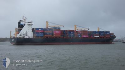
EF OLIVIA
Container Ship
Current Trip
| Trip Time | 11 days |
|---|---|
| Trip Distance | 2990.30 nm |
| AVG Speed | 14 Knots |
| MAX Speed | 20.5 Knots |
| Dybgang | 11.6 m |
| AVG Wind | 13 knots |
| MAX Wind | 29.3 knots |
| MIN Temp | 7°C / 44.6°F |
| MAX Temp | 19.8°C / 67.64°F |
| Position Modtaget | 2 d siden |
Current Position
| Longitude | 15.26191° |
|---|---|
| Latitude | 37.19528° |
| Status | Under way using engine |
| Fart | 8.2 Knots |
| Kurs | 266.7° |
| Område | Ionian Sea |
| Station | T-AIS |
| Position Modtaget | 2 d siden |
Info
Information
The current position of EF OLIVIA is in Ionian Sea with coordinates 37.19528° / 15.26191° as reported on 2024-04-22 18:27 by AIS to our vessel tracker app. The vessel's current speed is 8.2 Knots and is currently inside the port of AUGUSTA.
The vessel EF OLIVIA (IMO: 9252735, MMSI: 255805987) is a Container Ship that was built in 2006 ( 18 år gamle ). It's sailing under the flag of [PT] Portugal.
In this page you can find informations about the vessels current position, last detected port calls, and current voyage information. If the vessels is not in coverage by AIS you will find the latest position.
The current position of EF OLIVIA is detected by our AIS receivers and we are not responsible for the reliability of the data. The last position was recorded while the vessel was in Coverage by the Ais receivers of our vessel tracking app.
The current draught of EF OLIVIA as reported by AIS is 11.6 meters
Weather
| Temperature | 10.7°C / 51.26°F |
|---|---|
| Wind Speed | 12 knots |
| Direction | 287° WNW |
| Pressure | 1009.4 hPa |
| Humidity | 71 % |
| Cloud Coverage | --- |
Featured Company
Last Port Calls
| Port | Arrival | Departure | Time In Port |
|---|---|---|---|
| 2024-04-22 18:36 | |||
| 2024-04-09 17:53 | 2024-04-10 23:22 | 1 d | |
| 2024-04-08 04:24 | 2024-04-08 21:20 | 16 h | |
| 2024-04-06 03:26 | 2024-04-07 14:40 | 1 d | |
| 2024-04-04 12:55 | 2024-04-05 00:13 | 11 h | |
| 2024-03-31 15:23 | 2024-04-01 11:07 | 19 h | |
| 2024-03-18 12:25 | 2024-03-19 06:10 | 17 h | |
| 2024-03-17 05:28 | 2024-03-17 15:27 | 9 h | |
| 2024-03-16 03:26 | 2024-03-17 00:20 | 20 h | |
| 2024-03-14 15:57 | 2024-03-15 22:58 | 1 d |
Most Visited Ports (Last year)
| Port | Arrivals | |
|---|---|---|
| 8 | ||
| 8 | ||
| 8 | ||
| 8 | ||
| 7 | ||
| 7 |
Last Trips
| Origin | Departure | Destination | Arrival | Distance | |
|---|---|---|---|---|---|
| 2024-04-11 01:22 | 2024-04-22 20:36 | 2990.30 nm | |||
| 2024-04-08 23:20 | 2024-04-09 19:53 | 302.34 nm | |||
| 2024-04-07 16:40 | 2024-04-08 06:24 | 143.75 nm | |||
| 2024-04-05 01:13 | 2024-04-06 05:26 | 284.38 nm | |||
| 2024-04-01 11:07 | 2024-04-04 13:55 | 1209.60 nm | |||
| 2024-03-19 09:10 | 2024-03-31 15:23 | 1946.55 nm | |||
| 2024-03-17 18:27 | 2024-03-18 15:25 | 287.80 nm | |||
| 2024-03-17 03:20 | 2024-03-17 08:28 | 58.51 nm | |||
| 2024-03-16 01:58 | 2024-03-16 06:26 | 49.79 nm | |||
| 2024-03-12 16:36 | 2024-03-14 18:57 | 837.28 nm |
Events
| Tid | Hændelsen | Detaljer | Position / Dest | Info |
|---|---|---|---|---|
| 2024-04-22 19:19 | STOP Sejllads |
37.20500 / 15.20667
[IT] AUGUSTA
|
Fart: Kurs: -1° |
|
| 2024-04-22 18:36 | Skibe i havn |
|
37.19668 / 15.23310
[IT] AUGUSTA
|
Fart: 9.4 kn Kurs: 274° |
| 2024-04-22 18:32 | Status er ændret | Default Under way using engine |
37.19649 / 15.24628
IT AUG
|
Fart: 8.2 kn Kurs: 266.7° |
| 2024-04-22 18:27 | Udenfor Dækning |
37.19528 / 15.26191
Ionian Sea
[IT] AUGUSTA
|
Fart: 8.2 kn Kurs: 266.7° |
|
| 2024-04-22 18:27 | Status er ændret | Under way using engine Default |
37.19532 / 15.26287
IT AUG
|
Fart: 6.4 kn Kurs: 265° |
| 2024-04-22 18:12 | Indenfor Dækning |
37.19528 / 15.26191
Ionian Sea
IT AUG
|
Fart: 8.2 kn Kurs: 266.7° |
|
| 2024-04-22 17:44 | START Sejllads | 2.3 nm, North East of SANTA PANAGIA |
37.13650 / 15.30434
IT AUG
|
Fart: 4.3 kn Kurs: 83° |
| 2024-04-22 16:52 | STOP Sejllads | 3.62 nm, North East of SANTA PANAGIA |
37.15340 / 15.32270
IT AUG
|
Fart: Kurs: 58° |
| 2024-04-22 16:48 | Status er ændret | Default Restricted manoeuverability |
37.15303 / 15.32278
IT AUG
|
Fart: 3.8 kn Kurs: 346° |
| 2024-04-22 16:42 | Udenfor Dækning |
37.14978 / 15.32489
Ionian Sea
IT AUG
|
Fart: 3.8 kn Kurs: 324° |