
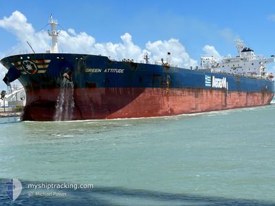
GREEN ATTITUDE
Tanker
Current Trip
| Time Travelled | 32 days |
|---|---|
| Remaining Time | --- |
| Distance Travelled | 7622.06 nm |
| Remaining Distance | --- |
| AVG Speed | 10 Knots |
| MAX Speed | 17 Knots |
| AVG Wind | 12.3 knots |
| MAX Wind | 40 knots |
| MIN Temp | 3°C / 37.4°F |
| MAX Temp | 22.9°C / 73.22°F |
| Dybgang | 9 m |
| Position Modtaget | 8 d siden |
Current Position
| Longitude | -24.12204° |
|---|---|
| Latitude | 32.18115° |
| Status | Under way using engine |
| Fart | 13 Knots |
| Kurs | 273.9° |
| Område | North Atlantic Ocean |
| Station | T-AIS |
| Position Modtaget | 8 d siden |
Info
Information
The current position of GREEN ATTITUDE is in North Atlantic Ocean with coordinates 32.18115° / -24.12204° as reported on 2024-04-10 07:12 by AIS to our vessel tracker app. The vessel's current speed is 13 Knots and is heading at the port of GEORGETOWN. The estimated time of arrival as calculated by MyShipTracking vessel tracking app is 2024-04-20 14:00 LT
The vessel GREEN ATTITUDE (IMO: 9808156, MMSI: 636018579) is a Tanker It's sailing under the flag of [LR] Liberia.
In this page you can find informations about the vessels current position, last detected port calls, and current voyage information. If the vessels is not in coverage by AIS you will find the latest position.
The current position of GREEN ATTITUDE is detected by our AIS receivers and we are not responsible for the reliability of the data. The last position was recorded while the vessel was in Coverage by the Ais receivers of our vessel tracking app.
The current draught of GREEN ATTITUDE as reported by AIS is 9 meters
Weather
| Temperature | 22.7°C / 72.86°F |
|---|---|
| Wind Speed | 8 knots |
| Direction | 99° E |
| Pressure | 1018.9 hPa |
| Humidity | 70.5 % |
| Cloud Coverage | 3 % |
Featured Company
Last Port Calls
| Port | Arrival | Departure | Time In Port |
|---|---|---|---|
| 2024-03-14 10:39 | 2024-03-17 01:25 | 2 d | |
| 2024-03-11 06:13 | 2024-03-14 07:03 | 3 d | |
| 2024-02-21 01:41 | 2024-02-23 14:40 | 2 d | |
| 2024-02-10 04:16 | 2024-02-11 09:56 | 1 d |
Most Visited Ports (Last year)
| Port | Arrivals | |
|---|---|---|
| 5 | ||
| 2 | ||
| 2 | ||
| 2 | ||
| 1 | ||
| 1 |
Last Trips
| Origin | Departure | Destination | Arrival | Distance | |
|---|---|---|---|---|---|
| 2024-03-14 03:03 | 2024-03-14 06:39 | 27.13 nm | |||
| 2024-02-23 15:40 | 2024-03-11 02:13 | 4219.54 nm | |||
| 2024-02-11 06:26 | 2024-02-21 02:41 | 2514.20 nm | |||
| 2024-01-28 06:50 | 2024-02-10 00:46 | 2790.94 nm |
Events
| Tid | Hændelsen | Detaljer | Position / Dest | Info |
|---|---|---|---|---|
| 2024-04-10 07:20 | Status er ændret | Default Under way using engine |
32.18246 / -24.15682
GUYANA
|
Fart: 13 kn Kurs: 273.9° |
| 2024-04-10 07:12 | Status er ændret | Under way using engine Default |
32.18115 / -24.12204
GUYANA
|
Fart: 13.1 kn Kurs: 271° |
| 2024-04-10 07:12 | Udenfor Dækning |
32.18115 / -24.12204
North Atlantic Ocean
GUYANA
|
Fart: 13 kn Kurs: 273.9° |
|
| 2024-04-10 07:02 | Indenfor Dækning |
32.18115 / -24.12204
North Atlantic Ocean
GUYANA
|
Fart: 13 kn Kurs: 273.9° |
|
| 2024-04-10 05:19 | Status er ændret | Default Under way using engine |
32.16518 / -23.64220
GUYANA
|
Fart: 13.2 kn Kurs: 271.3° |
| 2024-04-10 05:14 | Udenfor Dækning |
32.16499 / -23.62070
North Atlantic Ocean
GUYANA
|
Fart: 13.2 kn Kurs: 271.3° |
|
| 2024-04-10 05:01 | Status er ændret | Under way using engine Default |
32.16446 / -23.56410
GUYANA
|
Fart: 13.2 kn Kurs: 271° |
| 2024-04-10 04:52 | Indenfor Dækning |
32.16448 / -23.56689
North Atlantic Ocean
GUYANA
|
Fart: 13.2 kn Kurs: 269.9° |
|
| 2024-04-10 01:46 | Status er ændret | Default Under way using engine |
32.14173 / -22.73306
GUYANA
|
Fart: 12.9 kn Kurs: 273.8° |
| 2024-04-10 01:39 | Udenfor Dækning |
32.14109 / -22.70336
North Atlantic Ocean
GUYANA
|
Fart: 12.9 kn Kurs: 273.8° |