
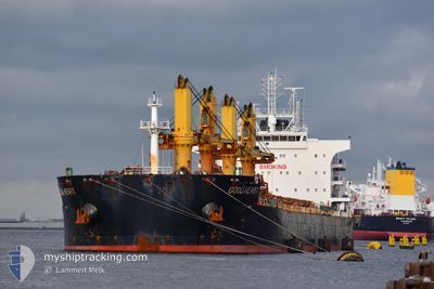
GOOD HEART
Cargo
Current Trip
| Time Travelled | 24 days |
|---|---|
| Remaining Time | --- |
| Distance Travelled | 6388.27 nm |
| Remaining Distance | --- |
| AVG Speed | 11.2 Knots |
| MAX Speed | 13.8 Knots |
| AVG Wind | 10 knots |
| MAX Wind | 19 knots |
| MIN Temp | 12.2°C / 53.96°F |
| MAX Temp | 30.1°C / 86.18°F |
| Dybgang | 11.4 m |
| Position Modtaget | 1 d siden |
Current Position
| Longitude | 54.55331° |
|---|---|
| Latitude | -20.85476° |
| Status | Under way using engine |
| Fart | 11.5 Knots |
| Kurs | 231.5° |
| Område | Indian Ocean |
| Station | T-AIS |
| Position Modtaget | 1 d siden |
Info
Information
The current position of GOOD HEART is in Indian Ocean with coordinates -20.85476° / 54.55331° as reported on 2024-04-24 05:32 by AIS to our vessel tracker app. The vessel's current speed is 11.5 Knots and is heading at the port of KLAIPEDA. The estimated time of arrival as calculated by MyShipTracking vessel tracking app is 2024-05-27 19:00 LT
The vessel GOOD HEART (IMO: 9669380, MMSI: 636021148) is a Cargo It's sailing under the flag of [LR] Liberia.
In this page you can find informations about the vessels current position, last detected port calls, and current voyage information. If the vessels is not in coverage by AIS you will find the latest position.
The current position of GOOD HEART is detected by our AIS receivers and we are not responsible for the reliability of the data. The last position was recorded while the vessel was in Coverage by the Ais receivers of our vessel tracking app.
The current draught of GOOD HEART as reported by AIS is 11.4 meters
Weather
| Temperature | 24.9°C / 76.82°F |
|---|---|
| Wind Speed | 10 knots |
| Direction | 79° E |
| Pressure | 1016.1 hPa |
| Humidity | 79.6 % |
| Cloud Coverage | 9 % |
Featured Company
Most Visited Ports (Last year)
| Port | Arrivals | |
|---|---|---|
| 2 | ||
| 2 | ||
| 2 | ||
| 1 | ||
| 1 | ||
| 1 |
Events
| Tid | Hændelsen | Detaljer | Position / Dest | Info |
|---|---|---|---|---|
| 2024-04-24 05:47 | Status er ændret | Default Under way using engine |
-20.88450 / 54.51400
LT KLJ
|
Fart: 11.5 kn Kurs: 231.5° |
| 2024-04-24 05:32 | Udenfor Dækning |
-20.85476 / 54.55331
Indian Ocean
|
Fart: 11.5 kn Kurs: 231.5° |
|
| 2024-04-24 05:21 | Status er ændret | Under way using engine Default |
-20.83387 / 54.58217
LT KLJ
|
Fart: 11.6 kn Kurs: 236° |
| 2024-04-24 05:18 | Status er ændret | Default Under way using engine |
-20.82785 / 54.59085
LT KLJ
|
Fart: 11.5 kn Kurs: 236.3° |
| 2024-04-24 02:29 | ETA er ændret | 2024/05/27 19:00 2024/05/27 09:00 |
-20.59284 / 55.10174
LT KLJ
|
Fart: 11.5 kn Kurs: 243.3° |
| 2024-04-23 23:51 | Status er ændret | Under way using engine Default |
-20.39211 / 55.58599
LT KLJ
|
Fart: 11.5 kn Kurs: 246° |
| 2024-04-23 23:27 | Status er ændret | Default Under way using engine |
-20.36094 / 55.65940
LT KLJ
|
Fart: 11.3 kn Kurs: 245.5° |
| 2024-04-23 23:20 | Ændre havområde | R�union part of the Indian Ocean Indonesian part of the Singapore Strait |
-20.35096 / 55.68223
Indian Ocean
|
Fart: 11.3 kn Kurs: 245.5° |
| 2024-04-23 23:20 | Status er ændret | Under way using engine Default |
-20.35096 / 55.68223
LT KLJ
|
Fart: 11.3 kn Kurs: 245° |
| 2024-04-23 23:07 | Indenfor Dækning |
-20.35096 / 55.68223
Indian Ocean
|
Fart: 11.3 kn Kurs: 245.5° |