
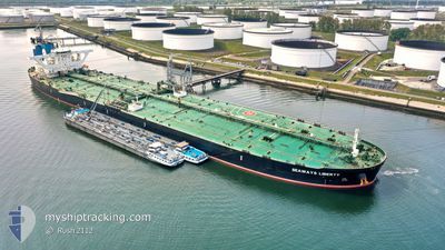
SEAWAYS LIBERTY
Tanker
Current Trip
ACU
| Time Travelled | 53 days |
|---|---|
| Remaining Time | --- |
| Distance Travelled | 12695.60 nm |
| Remaining Distance | --- |
| AVG Speed | 12 Knots |
| MAX Speed | 16.8 Knots |
| AVG Wind | 10.5 knots |
| MAX Wind | 26.2 knots |
| MIN Temp | 4.7°C / 40.46°F |
| MAX Temp | 30.8°C / 87.44°F |
| Dybgang | 11 m |
| Position Modtaget | 4 d siden |
Current Position
| Longitude | -40.72691° |
|---|---|
| Latitude | -21.84776° |
| Status | Under way using engine |
| Fart | 10.3 Knots |
| Kurs | 96.2° |
| Område | South Atlantic Ocean |
| Station | T-AIS |
| Position Modtaget | 4 d siden |
Info
Information
The current position of SEAWAYS LIBERTY is in South Atlantic Ocean with coordinates -21.84776° / -40.72691° as reported on 2024-04-20 12:09 by AIS to our vessel tracker app. The vessel's current speed is 10.3 Knots
The vessel SEAWAYS LIBERTY (IMO: 9727027, MMSI: 538006448) is a Tanker It's sailing under the flag of [MH] Marshall Is.
In this page you can find informations about the vessels current position, last detected port calls, and current voyage information. If the vessels is not in coverage by AIS you will find the latest position.
The current position of SEAWAYS LIBERTY is detected by our AIS receivers and we are not responsible for the reliability of the data. The last position was recorded while the vessel was in Coverage by the Ais receivers of our vessel tracking app.
The current draught of SEAWAYS LIBERTY as reported by AIS is 11 meters
Weather
| Temperature | 21.9°C / 71.42°F |
|---|---|
| Wind Speed | 13 knots |
| Direction | 50° NE |
| Pressure | 1020.2 hPa |
| Humidity | 82.8 % |
| Cloud Coverage | 62 % |
Featured Company
Last Trips
| Origin | Departure | Destination | Arrival | Distance |
|---|
Events
| Tid | Hændelsen | Detaljer | Position / Dest | Info |
|---|---|---|---|---|
| 2024-04-22 22:29 | START Sejllads |
-25.63545 / -29.29366
ACU
|
Fart: 3.3 kn Kurs: 170° |
|
| 2024-04-22 20:28 | STOP Sejllads |
-25.63772 / -29.28460
ACU
|
Fart: 0.3 kn Kurs: 190° |
|
| 2024-04-20 12:15 | Status er ændret | Default Under way using engine |
-21.85121 / -40.71079
ACU
|
Fart: 10.3 kn Kurs: 96.2° |
| 2024-04-20 12:09 | Udenfor Dækning |
-21.84776 / -40.72691
South Atlantic Ocean
|
Fart: 10.3 kn Kurs: 96.2° |
|
| 2024-04-20 11:55 | Status er ændret | Under way using engine Default |
-21.83999 / -40.76903
ACU
|
Fart: 8.8 kn Kurs: 102° |
| 2024-04-20 11:39 | Status er ændret | Default Under way using engine |
-21.83521 / -40.80724
ACU
|
Fart: 9.9 kn Kurs: 98.5° |
| 2024-04-20 11:34 | Status er ændret | Under way using engine Default |
-21.83331 / -40.82297
ACU
|
Fart: 10 kn Kurs: 97° |
| 2024-04-20 11:19 | Indenfor Dækning |
-21.83331 / -40.82297
South Atlantic Ocean
|
Fart: 9.9 kn Kurs: 98.5° |
|
| 2024-04-20 10:32 | START Sejllads | 3.92 nm, North East of PORTO DO ACU |
-21.79691 / -40.97595
ACU
|
Fart: 3.2 kn Kurs: 112° |
| 2024-04-20 08:17 | Udenfor Dækning |
-21.80582 / -40.97931
South Atlantic Ocean
|
Fart: Kurs: 268° |