
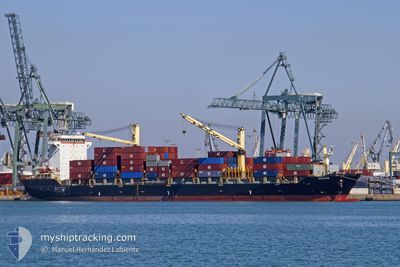
EMORA
Container Ship
Current Trip
| Time Travelled | 7 days |
|---|---|
| Remaining Time | --- |
| Distance Travelled | 1517.38 nm |
| Remaining Distance | --- |
| AVG Speed | 12.3 Knots |
| MAX Speed | 16 Knots |
| AVG Wind | 8.3 knots |
| MAX Wind | 20 knots |
| MIN Temp | 25°C / 77°F |
| MAX Temp | 29.7°C / 85.46°F |
| Dybgang | 10.6 m |
| Position Modtaget | 7 d siden |
Current Position
| Longitude | 120.09388° |
|---|---|
| Latitude | 22.47654° |
| Status | Under way using engine |
| Fart | 14 Knots |
| Kurs | 240.2° |
| Område | South China Sea |
| Station | T-AIS |
| Position Modtaget | 7 d siden |
Info
Information
The current position of EMORA is in South China Sea with coordinates 22.47654° / 120.09388° as reported on 2024-04-17 19:54 by AIS to our vessel tracker app. The vessel's current speed is 14 Knots and is heading at the port of CAGAYAN DE ORO. The estimated time of arrival as calculated by MyShipTracking vessel tracking app is 2024-04-20 23:00 LT
The vessel EMORA (IMO: 9362700, MMSI: 356298000) is a Container Ship that was built in 2007 ( 17 år gamle ). It's sailing under the flag of [PA] Panama.
In this page you can find informations about the vessels current position, last detected port calls, and current voyage information. If the vessels is not in coverage by AIS you will find the latest position.
The current position of EMORA is detected by our AIS receivers and we are not responsible for the reliability of the data. The last position was recorded while the vessel was in Coverage by the Ais receivers of our vessel tracking app.
The current draught of EMORA as reported by AIS is 10.6 meters
Weather
| Temperature | 24.9°C / 76.82°F |
|---|---|
| Wind Speed | 7 knots |
| Direction | 356° N |
| Pressure | 1011.1 hPa |
| Humidity | 84.3 % |
| Cloud Coverage | 48 % |
Featured Company
Last Port Calls
| Port | Arrival | Departure | Time In Port |
|---|---|---|---|
| 2024-04-16 21:26 | 2024-04-17 19:06 | 21 h | |
| 2024-04-11 07:46 | 2024-04-12 14:34 | 1 d | |
| 2024-04-02 10:03 | 2024-04-03 10:06 | 1 d | |
| 2024-03-28 02:40 | 2024-03-29 11:33 | 1 d | |
| 2024-03-19 16:08 | 2024-03-20 20:04 | 1 d | |
| 2024-03-14 07:45 | |||
| 2024-03-05 14:12 | 2024-03-06 20:15 | 1 d | |
| 2024-02-29 05:45 | 2024-03-02 02:49 | 1 d | |
| 2024-02-20 22:02 | 2024-02-21 19:35 | 21 h | |
| 2024-02-16 09:06 | 2024-02-17 23:07 | 1 d |
Most Visited Ports (Last year)
| Port | Arrivals | |
|---|---|---|
| 24 | ||
| 22 | ||
| 2 | ||
| 1 | ||
| 1 | ||
| 1 |
Last Trips
| Origin | Departure | Destination | Arrival | Distance | |
|---|---|---|---|---|---|
| 2024-04-12 22:34 | 2024-04-17 05:26 | 1213.39 nm | |||
| 2024-04-03 18:06 | 2024-04-11 15:46 | 1697.60 nm | |||
| 2024-03-29 19:33 | 2024-04-02 18:03 | 1202.42 nm | |||
| 2024-03-21 04:04 | 2024-03-28 10:40 | 1690.69 nm | |||
| 2024-03-07 04:15 | 2024-03-14 15:45 | 1676.77 nm | |||
| 2024-03-02 10:49 | 2024-03-05 22:12 | 1176.72 nm | |||
| 2024-02-22 03:35 | 2024-02-29 13:45 | 1626.00 nm | |||
| 2024-02-18 07:07 | 2024-02-21 06:02 | 1176.20 nm | |||
| 2024-02-08 01:05 | 2024-02-16 17:06 | 1697.75 nm | |||
| 2024-02-03 23:46 | 2024-02-07 01:10 | 1195.83 nm |
Events
| Tid | Hændelsen | Detaljer | Position / Dest | Info |
|---|---|---|---|---|
| 2024-04-24 00:59 | STOP Sejllads | 3.55 nm, North of DAVAO |
7.17333 / 125.65500
PHCGY
|
Fart: Kurs: -1° |
| 2024-04-22 11:52 | START Sejllads | 3.41 nm, South of VILLANUEVA |
8.52238 / 124.74367
PHCGY
|
Fart: 5.3 kn Kurs: 282° |
| 2024-04-21 20:44 | STOP Sejllads | 3.42 nm, South of VILLANUEVA |
8.52130 / 124.74813
PHCGY
|
Fart: 0.3 kn Kurs: 322° |
| 2024-04-21 20:05 | START Sejllads | 3.12 nm, East of CAGAYAN DE ORO |
8.51175 / 124.71471
PHCGY
|
Fart: 4.3 kn Kurs: 83° |
| 2024-04-21 19:40 | STOP Sejllads | 2.75 nm, North East of CAGAYAN DE ORO |
8.51120 / 124.70833
PHCGY
|
Fart: 0.2 kn Kurs: 97° |
| 2024-04-21 18:21 | START Sejllads | 13 nm, North West of VILLANUEVA |
8.71035 / 124.58553
PHCGY
|
Fart: 3.6 kn Kurs: 229° |
| 2024-04-21 09:48 | STOP Sejllads | 15.46 nm, North West of VILLANUEVA |
8.76855 / 124.58338
PHCGY
|
Fart: 0.1 kn Kurs: 25° |
| 2024-04-21 08:04 | START Sejllads | 19.81 nm, North West of CAGAYAN DE ORO |
8.74910 / 124.45383
PHCGY
|
Fart: 3.2 kn Kurs: 53° |
| 2024-04-21 04:52 | STOP Sejllads | 21.52 nm, North West of CAGAYAN DE ORO |
8.76423 / 124.42717
PHCGY
|
Fart: 0.2 kn Kurs: 324° |
| 2024-04-17 19:54 | Udenfor Dækning |
22.47654 / 120.09388
South China Sea
PHCGY
|
Fart: 14 kn Kurs: 240.2° |