
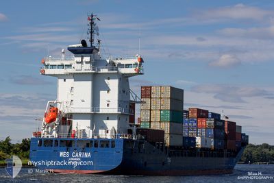
ELBWAVE
Container Ship
Current Trip
| Time Travelled | 15 h, 56 mins |
|---|---|
| Remaining Time | 1 day |
| Distance Travelled | 248.34 nm |
| Remaining Distance | 507.91 nm |
| AVG Speed | 15.5 Knots |
| MAX Speed | 17 Knots |
| AVG Wind | 11.1 knots |
| MAX Wind | 16 knots |
| MIN Temp | 0.3°C / 32.54°F |
| MAX Temp | 3.2°C / 37.76°F |
| Dybgang | 8.4 m |
| Position Modtaget | 1 h, 47 m siden |
Current Position
| Longitude | 18.35411° |
|---|---|
| Latitude | 58.12179° |
| Status | Under way using engine |
| Fart | 15.7 Knots |
| Kurs | 210.9° |
| Område | Baltic Sea |
| Station | T-AIS |
| Position Modtaget | 1 h, 47 m siden |
Info
Information
The current position of ELBWAVE is in Baltic Sea with coordinates 58.12179° / 18.35411° as reported on 2024-04-24 06:17 by AIS to our vessel tracker app. The vessel's current speed is 15.7 Knots and is heading at the port of BREMERHAVEN. The estimated time of arrival as calculated by MyShipTracking vessel tracking app is 2024-04-25 16:03 LT
The vessel ELBWAVE (IMO: 9504035, MMSI: 209276000) is a Container Ship that was built in 2011 ( 13 år gamle ). It's sailing under the flag of [CY] Cyprus.
In this page you can find informations about the vessels current position, last detected port calls, and current voyage information. If the vessels is not in coverage by AIS you will find the latest position.
The current position of ELBWAVE is detected by our AIS receivers and we are not responsible for the reliability of the data. The last position was recorded while the vessel was in Coverage by the Ais receivers of our vessel tracking app.
The current draught of ELBWAVE as reported by AIS is 8.4 meters
Weather
| Temperature | 2.9°C / 37.22°F |
|---|---|
| Wind Speed | 10 knots |
| Direction | 206° SSW |
| Pressure | 1011.5 hPa |
| Humidity | 84.8 % |
| Cloud Coverage | 32 % |
Featured Company
Last Port Calls
| Port | Arrival | Departure | Time In Port |
|---|---|---|---|
| 2024-04-22 10:50 | 2024-04-23 16:08 | 1 d | |
| 2024-04-21 03:57 | 2024-04-21 16:06 | 12 h | |
| 2024-04-19 10:23 | 2024-04-19 23:36 | 13 h | |
| 2024-04-16 20:27 | 2024-04-17 21:17 | 1 d | |
| 2024-04-15 20:11 | 2024-04-16 12:28 | 16 h | |
| 2024-04-13 15:00 | 2024-04-14 00:48 | 9 h | |
| 2024-04-11 15:27 | 2024-04-12 11:07 | 19 h | |
| 2024-04-08 03:02 | 2024-04-09 08:30 | 1 d | |
| 2024-04-06 14:29 | 2024-04-07 14:28 | 23 h | |
| 2024-04-05 23:02 | 2024-04-05 23:49 | 46 m |
Most Visited Ports (Last year)
| Port | Arrivals | |
|---|---|---|
| 30 | ||
| 29 | ||
| 14 | ||
| 14 | ||
| 9 | ||
| 9 |
Last Trips
| Origin | Departure | Destination | Arrival | Distance | |
|---|---|---|---|---|---|
| 2024-04-21 18:06 | 2024-04-22 12:50 | 271.19 nm | |||
| 2024-04-20 01:36 | 2024-04-21 05:57 | 308.56 nm | |||
| 2024-04-17 23:17 | 2024-04-19 12:23 | 445.64 nm | |||
| 2024-04-16 14:28 | 2024-04-16 22:27 | 113.70 nm | |||
| 2024-04-14 02:48 | 2024-04-15 22:11 | 489.19 nm | |||
| 2024-04-12 13:07 | 2024-04-13 17:00 | 435.64 nm | |||
| 2024-04-09 10:30 | 2024-04-11 17:27 | 722.45 nm | |||
| 2024-04-07 16:28 | 2024-04-08 05:02 | 119.53 nm | |||
| 2024-04-06 01:49 | 2024-04-06 16:29 | 132.51 nm | |||
| 2024-04-04 18:16 | 2024-04-06 01:02 | 464.61 nm |
Events
| Tid | Hændelsen | Detaljer | Position / Dest | Info |
|---|---|---|---|---|
| 2024-04-24 06:25 | Status er ændret | Default Under way using engine |
58.09307 / 18.32102
DEBRV
|
Fart: 15.7 kn Kurs: 210.9° |
| 2024-04-24 06:17 | Udenfor Dækning |
58.12179 / 18.35411
Baltic Sea
DEBRV
|
Fart: 15.7 kn Kurs: 210.9° |
|
| 2024-04-24 06:09 | Status er ændret | Under way using engine Default |
58.15280 / 18.38928
DEBRV
|
Fart: 15.7 kn Kurs: 210° |
| 2024-04-24 06:04 | Status er ændret | Default Under way using engine |
58.16994 / 18.40861
DEBRV
|
Fart: 15.7 kn Kurs: 210.9° |
| 2024-04-23 23:58 | Ændre havområde | Swedish part of the Baltic Sea Finnish part of the Baltic Sea |
59.56873 / 19.96570
Baltic Sea
DEBRV
|
Fart: 16.4 kn Kurs: 184.7° |
| 2024-04-23 23:13 | Ændre havområde | Finnish part of the Baltic Sea Swedish part of the Baltic Sea |
59.73322 / 19.74493
Baltic Sea
DEBRV
|
Fart: 16.7 kn Kurs: 138° |
| 2024-04-23 22:52 | Ændre havområde | Swedish part of the Baltic Sea Swedish part of the Gulf of Bothnia |
59.80563 / 19.61935
Baltic Sea
DEBRV
|
Fart: 16.6 kn Kurs: 140° |
| 2024-04-23 18:39 | Status er ændret | Under way using engine Default |
60.67506 / 18.41708
DEBRV
|
Fart: 15.8 kn Kurs: 121° |
| 2024-04-23 18:32 | Status er ændret | Default Under way using engine |
60.69010 / 18.36562
DEBRV
|
Fart: 15.9 kn Kurs: 118.2° |
| 2024-04-23 16:12 | ETA er ændret | 2024/04/25 22:30 2024/04/26 18:00 |
60.70333 / 17.26459
DEBRV
|
Fart: 11.4 kn Kurs: 30° |