
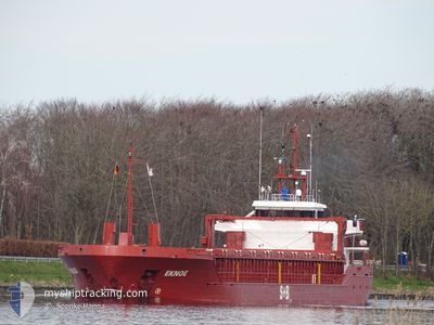
EKNOE
General Cargo
Current Trip
LV SAL
| Time Travelled | 19 h, 12 mins |
|---|---|
| Remaining Time | --- |
| Distance Travelled | 146.78 nm |
| Remaining Distance | --- |
| AVG Speed | 8.4 Knots |
| MAX Speed | 12.3 Knots |
| AVG Wind | 7.8 knots |
| MAX Wind | 16.8 knots |
| MIN Temp | 0.7°C / 33.26°F |
| MAX Temp | 5.8°C / 42.44°F |
| Dybgang | 3.4 m |
| Position Modtaget | 1 m siden |
Current Position
| Longitude | 12.63097° |
|---|---|
| Latitude | 54.64742° |
| Status | Under way using engine |
| Fart | 11.7 Knots |
| Kurs | 67.3° |
| Område | Baltic Sea |
| Station | T-AIS |
| Position Modtaget | 1 m siden |
Info
Information
The current position of EKNOE is in Baltic Sea with coordinates 54.64742° / 12.63097° as reported on 2024-04-24 12:45 by AIS to our vessel tracker app. The vessel's current speed is 11.7 Knots
The vessel EKNOE (IMO: 9353395, MMSI: 304936000) is a General Cargo that was built in 2006 ( 18 år gamle ). It's sailing under the flag of [AG] Antigua Barbuda.
In this page you can find informations about the vessels current position, last detected port calls, and current voyage information. If the vessels is not in coverage by AIS you will find the latest position.
The current position of EKNOE is detected by our AIS receivers and we are not responsible for the reliability of the data. The last position was recorded while the vessel was in Coverage by the Ais receivers of our vessel tracking app.
The current draught of EKNOE as reported by AIS is 3.4 meters
Weather
| Temperature | 6.1°C / 42.98°F |
|---|---|
| Wind Speed | 13 knots |
| Direction | 127° SE |
| Pressure | 1007.1 hPa |
| Humidity | 76.4 % |
| Cloud Coverage | 99 % |
Featured Company
Last Port Calls
| Port | Arrival | Departure | Time In Port |
|---|---|---|---|
| 2024-04-23 14:41 | 2024-04-23 17:34 | 2 h | |
| 2024-04-23 12:38 | 2024-04-23 14:38 | 2 h | |
| 2024-04-21 21:08 | 2024-04-22 22:41 | 1 d | |
| 2024-04-17 14:09 | 2024-04-18 15:20 | 1 d | |
| 2024-04-16 03:14 | 2024-04-16 03:17 | 3 m | |
| 2024-04-14 02:03 | 2024-04-15 03:02 | 1 d | |
| 2024-04-09 15:53 | 2024-04-10 14:39 | 22 h | |
| 2024-04-06 08:31 | 2024-04-06 08:33 | 1 m | |
| 2024-04-03 17:00 | 2024-04-05 09:13 | 1 d | |
| 2024-03-29 16:33 | 2024-03-30 18:05 | 1 d |
Last Trips
| Origin | Departure | Destination | Arrival | Distance | |
|---|---|---|---|---|---|
| 2024-04-23 16:38 | 2024-04-23 16:41 | 0.07 nm | |||
| 2024-04-23 00:41 | 2024-04-23 14:38 | 160.10 nm | |||
| 2024-04-18 18:20 | 2024-04-21 23:08 | 645.38 nm | |||
| 2024-04-16 05:17 | 2024-04-17 17:09 | 406.82 nm | |||
| 2024-04-15 05:02 | 2024-04-16 05:14 | 211.81 nm | |||
| 2024-04-10 17:39 | 2024-04-14 04:03 | 801.78 nm | |||
| 2024-04-06 10:33 | 2024-04-09 18:53 | 706.37 nm | |||
| 2024-04-05 11:13 | 2024-04-06 10:31 | 216.60 nm | |||
| 2024-03-30 20:05 | 2024-04-03 19:00 | 904.61 nm | |||
| 2024-03-28 14:09 | 2024-03-29 18:33 | 287.21 nm |
Events
| Tid | Hændelsen | Detaljer | Position / Dest | Info |
|---|---|---|---|---|
| 2024-04-24 10:41 | Fundet i havområde | German part of the Baltic Sea |
54.41338 / 12.12954
Baltic Sea
LV SAL
|
Fart: 11.3 kn Kurs: 92.9° |
| 2024-04-24 08:29 | Fundet i havområde | Danish part of the Baltic Sea |
54.50756 / 11.43499
Baltic Sea
LV SAL
|
Fart: 11.8 kn Kurs: 118.1° |
| 2024-04-24 06:30 | Dybgangen er ændret | 3.4 3.2 |
54.56517 / 10.83251
LV SAL
|
Fart: 12 kn Kurs: 83.8° |
| 2024-04-24 06:30 | ETA er ændret | 2024/04/26 04:00 2024/04/25 21:00 |
54.56517 / 10.83251
LV SAL
|
Fart: 12 kn Kurs: 83.8° |
| 2024-04-24 06:20 | Ændre havområde | German part of the Baltic Sea Danish part of the Baltic Sea |
54.56098 / 10.77058
Baltic Sea
LV SAL
|
Fart: 11.9 kn Kurs: 84.4° |
| 2024-04-24 05:53 | Ændre havområde | Danish part of the Baltic Sea German part of the Baltic Sea |
54.55199 / 10.62040
Baltic Sea
LV SAL
|
Fart: 11.4 kn Kurs: 84.8° |
| 2024-04-24 04:40 | Ændre havområde | German part of the Baltic Sea German part of the North Sea |
54.46422 / 10.26510
Baltic Sea
LV SAL
|
Fart: 12.3 kn Kurs: 32.9° |
| 2024-04-24 03:58 | START Sejllads | 1.31 nm, South West of STICKENHΟRN SPORT |
54.36554 / 10.14549
LV SAL
|
Fart: 4 kn Kurs: 103° |
| 2024-04-24 03:17 | STOP Sejllads | 1.35 nm, South West of STICKENHΟRN SPORT |
54.36597 / 10.14245
LV SAL
|
Fart: 0.3 kn Kurs: 106° |
| 2024-04-24 01:44 | START Sejllads | 6.11 nm, East of BORGSTEDT |
54.35437 / 9.88674
LV SAL
|
Fart: 4.7 kn Kurs: 113° |