
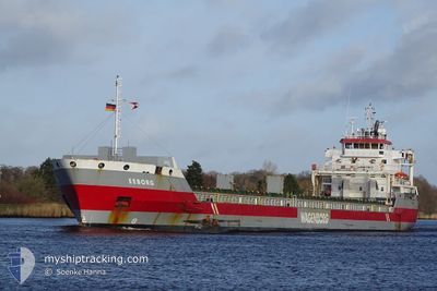
EEBORG
General Cargo
Current Trip
| Trip Time | 3 days |
|---|---|
| Trip Distance | 802.10 nm |
| AVG Speed | 11.9 Knots |
| MAX Speed | 14 Knots |
| Dybgang | 5.2 m |
| AVG Wind | 14.6 knots |
| MAX Wind | 29 knots |
| MIN Temp | 14.9°C / 58.82°F |
| MAX Temp | 21.8°C / 71.24°F |
| Position Modtaget | 1 d siden |
Current Position
| Longitude | 14.11112° |
|---|---|
| Latitude | 36.65598° |
| Status | Under way using engine |
| Fart | 8.6 Knots |
| Kurs | 297.2° |
| Område | Mediterranean Sea - Eastern Basin |
| Station | T-AIS |
| Position Modtaget | 1 d siden |
Info
Information
The current position of EEBORG is in Mediterranean Sea - Eastern Basin with coordinates 36.65598° / 14.11112° as reported on 2024-04-18 03:54 by AIS to our vessel tracker app. The vessel's current speed is 8.6 Knots and is currently inside the port of PORTO EMPEDOCLE.
The vessel EEBORG (IMO: 9568328, MMSI: 246846000) is a General Cargo that was built in 2012 ( 12 år gamle ). It's sailing under the flag of [NL] Netherlands.
In this page you can find informations about the vessels current position, last detected port calls, and current voyage information. If the vessels is not in coverage by AIS you will find the latest position.
The current position of EEBORG is detected by our AIS receivers and we are not responsible for the reliability of the data. The last position was recorded while the vessel was in Coverage by the Ais receivers of our vessel tracking app.
The current draught of EEBORG as reported by AIS is 5.2 meters
Weather
| Temperature | 10°C / 50°F |
|---|---|
| Wind Speed | 8 knots |
| Direction | 335° NNW |
| Pressure | 1016.2 hPa |
| Humidity | 79.6 % |
| Cloud Coverage | 1 % |
Featured Company
Last Port Calls
| Port | Arrival | Departure | Time In Port |
|---|---|---|---|
| 2024-04-18 09:34 | |||
| 2024-04-13 09:21 | 2024-04-14 13:53 | 1 d | |
| 2024-03-29 04:27 | 2024-03-31 02:17 | 1 d | |
| 2024-03-29 03:13 | 2024-03-29 03:26 | 12 m | |
| 2024-03-26 23:16 | 2024-03-28 22:02 | 1 d | |
| 2024-03-19 23:12 | 2024-03-21 11:38 | 1 d | |
| 2024-03-16 12:12 | 2024-03-17 14:00 | 1 d | |
| 2024-03-12 22:57 | 2024-03-15 23:18 | 3 d | |
| 2024-03-10 22:17 | 2024-03-11 20:32 | 22 h | |
| 2024-02-22 00:10 | 2024-02-26 21:37 | 4 d |
Last Trips
| Origin | Departure | Destination | Arrival | Distance | |
|---|---|---|---|---|---|
| 2024-04-14 15:53 | 2024-04-18 11:34 | 802.10 nm | |||
| 2024-03-31 04:17 | 2024-04-13 11:21 | 3101.19 nm | |||
| 2024-03-29 04:26 | 2024-03-29 05:27 | 7.08 nm | |||
| 2024-03-28 23:02 | 2024-03-29 04:13 | 24.44 nm | |||
| 2024-03-21 12:38 | 2024-03-27 00:16 | 1333.60 nm | |||
| 2024-03-17 15:00 | 2024-03-20 00:12 | 631.00 nm | |||
| 2024-03-16 00:18 | 2024-03-16 13:12 | 157.02 nm | |||
| 2024-03-11 21:32 | 2024-03-12 23:57 | 265.90 nm | |||
| 2024-02-26 23:37 | 2024-03-10 23:17 | 2898.49 nm | |||
| 2024-02-14 07:31 | 2024-02-16 02:28 | 320.87 nm |
Events
| Tid | Hændelsen | Detaljer | Position / Dest | Info |
|---|---|---|---|---|
| 2024-04-18 09:34 | Skibe i havn |
|
37.28140 / 13.52929
[IT] PORTO EMPEDOCLE
|
Fart: 10.1 kn Kurs: 2° |
| 2024-04-18 03:56 | Status er ændret | Default Under way using engine |
36.65884 / 14.10446
PORT EMPDOCLES
|
Fart: 8.6 kn Kurs: 297.2° |
| 2024-04-18 03:54 | Udenfor Dækning |
36.65598 / 14.11112
Mediterranean Sea - Eastern Basin
PORT EMPDOCLES
|
Fart: 8.6 kn Kurs: 297.2° |
|
| 2024-04-18 00:04 | Status er ændret | Under way using engine Default |
36.42690 / 14.75303
PORT EMPDOCLES
|
Fart: 9 kn Kurs: 272° |
| 2024-04-17 23:58 | Status er ændret | Default Under way using engine |
36.42500 / 14.77167
PORT EMPDOCLES
|
Fart: 8.9 kn Kurs: 272.8° |
| 2024-04-17 23:56 | Status er ændret | Under way using engine Default |
36.42612 / 14.77684
PORT EMPDOCLES
|
Fart: 8 kn Kurs: 272° |
| 2024-04-17 23:46 | Status er ændret | Default Under way using engine |
36.42333 / 14.80667
PORT EMPDOCLES
|
Fart: 9 kn Kurs: 272.9° |
| 2024-04-17 23:44 | Ændre havområde | Italian part of the Mediterranean Sea - Eastern Basin Italian part of the Ionian Sea |
36.42423 / 14.81410
Mediterranean Sea - Eastern Basin
PORT EMPDOCLES
|
Fart: 9 kn Kurs: 272.9° |
| 2024-04-17 23:44 | Status er ændret | Under way using engine Default |
36.42423 / 14.81410
PORT EMPDOCLES
|
Fart: 9 kn Kurs: 270° |
| 2024-04-17 23:31 | Indenfor Dækning |
36.42423 / 14.81410
Mediterranean Sea - Eastern Basin
PORT EMPDOCLES
|
Fart: 9 kn Kurs: 272.9° |