
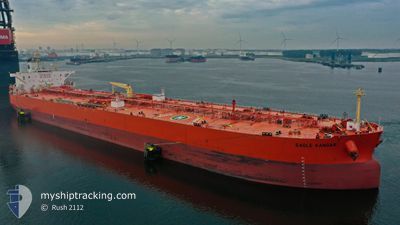
EAGLE KANGAR
Crude Oil Tanker
Current Trip
| Time Travelled | 6 days |
|---|---|
| Remaining Time | 20 h, 22 mins |
| Distance Travelled | 1724.48 nm |
| Remaining Distance | 290.86 nm |
| AVG Speed | 11.2 Knots |
| MAX Speed | 15.6 Knots |
| AVG Wind | 9.4 knots |
| MAX Wind | 20 knots |
| MIN Temp | 16.8°C / 62.24°F |
| MAX Temp | 27.4°C / 81.32°F |
| Dybgang | 11.5 m |
| Position Modtaget | 1 d siden |
Current Position
| Longitude | -79.73191° |
|---|---|
| Latitude | 26.94259° |
| Status | Under way using engine |
| Fart | 11.7 Knots |
| Kurs | 356.5° |
| Område | North Atlantic Ocean |
| Station | T-AIS |
| Position Modtaget | 1 d siden |
Info
Information
The current position of EAGLE KANGAR is in North Atlantic Ocean with coordinates 26.94259° / -79.73191° as reported on 2024-04-23 10:13 by AIS to our vessel tracker app. The vessel's current speed is 11.7 Knots and is heading at the port of PAULSBORO. The estimated time of arrival as calculated by MyShipTracking vessel tracking app is 2024-04-26 05:30 LT
The vessel EAGLE KANGAR (IMO: 9417024, MMSI: 563759000) is a Crude Oil Tanker that was built in 2010 ( 14 år gamle ). It's sailing under the flag of [SG] Singapore.
In this page you can find informations about the vessels current position, last detected port calls, and current voyage information. If the vessels is not in coverage by AIS you will find the latest position.
The current position of EAGLE KANGAR is detected by our AIS receivers and we are not responsible for the reliability of the data. The last position was recorded while the vessel was in Coverage by the Ais receivers of our vessel tracking app.
The current draught of EAGLE KANGAR as reported by AIS is 11.5 meters
Weather
| Temperature | 16.8°C / 62.24°F |
|---|---|
| Wind Speed | 11 knots |
| Direction | 328° NNW |
| Pressure | 1018.3 hPa |
| Humidity | 82.2 % |
| Cloud Coverage | 92 % |
Featured Company
Last Port Calls
| Port | Arrival | Departure | Time In Port |
|---|---|---|---|
| 2024-04-16 23:45 | 2024-04-18 22:07 | 1 d | |
| 2024-04-09 17:53 | 2024-04-11 21:11 | 2 d | |
| 2024-04-06 16:41 | 2024-04-07 21:17 | 1 d | |
| 2024-03-27 18:54 | 2024-03-29 17:54 | 1 d | |
| 2024-03-20 23:30 | 2024-03-22 14:51 | 1 d | |
| 2024-02-27 22:51 | 2024-03-01 15:06 | 2 d | |
| 2024-02-19 10:58 | 2024-02-20 20:41 | 1 d | |
| 2024-02-15 17:01 | 2024-02-17 13:16 | 1 d | |
| 2024-02-04 22:10 | 2024-02-05 23:56 | 1 d |
Most Visited Ports (Last year)
| Port | Arrivals | |
|---|---|---|
| 8 | ||
| 6 | ||
| 6 | ||
| 6 | ||
| 5 | ||
| 5 |
Last Trips
| Origin | Departure | Destination | Arrival | Distance | |
|---|---|---|---|---|---|
| 2024-04-11 16:11 | 2024-04-16 18:45 | 266.80 nm | |||
| 2024-04-07 16:17 | 2024-04-09 12:53 | 110.75 nm | |||
| 2024-03-29 12:54 | 2024-04-06 11:41 | 318.97 nm | |||
| 2024-03-22 09:51 | 2024-03-27 13:54 | 565.35 nm | |||
| 2024-03-01 09:06 | 2024-03-20 18:30 | 3452.68 nm | |||
| 2024-02-20 14:41 | 2024-02-27 16:51 | 159.70 nm | |||
| 2024-02-17 07:16 | 2024-02-19 04:58 | 202.87 nm | |||
| 2024-02-05 17:56 | 2024-02-15 11:01 | 463.55 nm | |||
| 2024-01-26 08:55 | 2024-02-04 16:10 | 2141.06 nm |
Events
| Tid | Hændelsen | Detaljer | Position / Dest | Info |
|---|---|---|---|---|
| 2024-04-23 10:18 | Status er ændret | Default Under way using engine |
26.95667 / -79.73167
PAULSBORO
|
Fart: 11.7 kn Kurs: 356.5° |
| 2024-04-23 10:13 | Udenfor Dækning |
26.94259 / -79.73191
North Atlantic Ocean
PAULSBORO
|
Fart: 11.7 kn Kurs: 356.5° |
|
| 2024-04-23 09:56 | Status er ændret | Under way using engine Default |
26.88561 / -79.72749
PAULSBORO
|
Fart: 12 kn Kurs: 354° |
| 2024-04-23 09:40 | Indenfor Dækning |
26.88561 / -79.72749
North Atlantic Ocean
PAULSBORO
|
Fart: 12 kn Kurs: 353.9° |
|
| 2024-04-23 08:12 | Status er ændret | Default Under way using engine |
26.51833 / -79.76500
PAULSBORO
|
Fart: 13.5 kn Kurs: 4.4° |
| 2024-04-23 08:02 | Udenfor Dækning |
26.48256 / -79.76896
North Atlantic Ocean
PAULSBORO
|
Fart: 13.5 kn Kurs: 4.4° |
|
| 2024-04-23 03:12 | Dybgangen er ændret | 11.5 9 |
25.48656 / -79.89796
PAULSBORO
|
Fart: 12.1 kn Kurs: 8.2° |
| 2024-04-23 03:12 | Destination er ændret | PAULSBORO GOLA |
25.48656 / -79.89796
PAULSBORO
|
Fart: 12.1 kn Kurs: 8.2° |
| 2024-04-23 03:12 | ETA er ændret | 2024/04/26 11:00 2024/04/19 08:00 |
25.48656 / -79.89796
PAULSBORO
|
Fart: 12.1 kn Kurs: 8.2° |
| 2024-04-23 02:19 | Ændre havområde | United States part of the North Atlantic Ocean United States part of the Gulf of Mexico |
25.30573 / -79.92626
North Atlantic Ocean
|
Fart: 12.5 kn Kurs: 6.3° |