
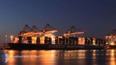
COSCO SHIPPING LIBRA
Cargo A
Current Trip
R0TTERDAM
| Time Travelled | 25 days |
|---|---|
| Remaining Time | --- |
| Distance Travelled | 11061.10 nm |
| Remaining Distance | --- |
| AVG Speed | 17.7 Knots |
| MAX Speed | 20.3 Knots |
| AVG Wind | 12.1 knots |
| MAX Wind | 40 knots |
| MIN Temp | 12.6°C / 54.68°F |
| MAX Temp | 30.5°C / 86.9°F |
| Dybgang | 15.6 m |
| Position Modtaget | 1 m siden |
Current Position
| Longitude | -9.17639° |
|---|---|
| Latitude | 43.97755° |
| Status | Under way using engine |
| Fart | 16.4 Knots |
| Kurs | 24.1° |
| Område | North Atlantic Ocean |
| Station | T-AIS |
| Position Modtaget | 1 m siden |
Info
Information
The current position of COSCO SHIPPING LIBRA is in North Atlantic Ocean with coordinates 43.97755° / -9.17639° as reported on 2024-04-19 07:18 by AIS to our vessel tracker app. The vessel's current speed is 16.4 Knots
The vessel COSCO SHIPPING LIBRA (IMO: 9783538, MMSI: 477172700) is a Cargo A It's sailing under the flag of [HK] Hong Kong.
In this page you can find informations about the vessels current position, last detected port calls, and current voyage information. If the vessels is not in coverage by AIS you will find the latest position.
The current position of COSCO SHIPPING LIBRA is detected by our AIS receivers and we are not responsible for the reliability of the data. The last position was recorded while the vessel was in Coverage by the Ais receivers of our vessel tracking app.
The current draught of COSCO SHIPPING LIBRA as reported by AIS is 15.6 meters
Weather
| Temperature | 12.6°C / 54.68°F |
|---|---|
| Wind Speed | 28 knots |
| Direction | 78° ENE |
| Pressure | 1018.7 hPa |
| Humidity | 82.4 % |
| Cloud Coverage | --- |
Featured Company
Most Visited Ports (Last year)
| Port | Arrivals | |
|---|---|---|
| 8 | ||
| 6 | ||
| 4 | ||
| 4 | ||
| 4 | ||
| 4 |
Events
| Tid | Hændelsen | Detaljer | Position / Dest | Info |
|---|---|---|---|---|
| 2024-04-19 03:26 | Status er ændret | Under way using engine Default |
43.03721 / -9.79460
R0TTERDAM
|
Fart: 17 kn Kurs: 1° |
| 2024-04-19 03:14 | Status er ændret | Default Under way using engine |
42.97833 / -9.79667
R0TTERDAM
|
Fart: 17.4 kn Kurs: 2.2° |
| 2024-04-19 01:29 | Status er ændret | Under way using engine Default |
42.48962 / -9.93960
R0TTERDAM
|
Fart: 17.3 kn Kurs: 17° |
| 2024-04-19 01:13 | Indenfor Dækning |
42.49661 / -9.93668
North Atlantic Ocean
R0TTERDAM
|
Fart: 17.3 kn Kurs: 17.4° |
|
| 2024-04-19 00:41 | Status er ændret | Default Under way using engine |
42.26742 / -10.03044
R0TTERDAM
|
Fart: 16.8 kn Kurs: 20° |
| 2024-04-18 23:58 | Udenfor Dækning |
42.07172 / -10.11192
North Atlantic Ocean
R0TTERDAM
|
Fart: 16.8 kn Kurs: 20° |
|
| 2024-04-18 22:47 | Ændre havområde | Spanish part of the North Atlantic Ocean Portuguese part of the North Atlantic Ocean |
41.75106 / -10.26031
North Atlantic Ocean
R0TTERDAM
|
Fart: 17.1 kn Kurs: 18.6° |
| 2024-04-18 18:00 | Status er ændret | Under way using engine Default |
40.45097 / -10.77504
R0TTERDAM
|
Fart: 16.8 kn Kurs: 17° |
| 2024-04-18 17:56 | Status er ændret | Default Under way using engine |
40.43617 / -10.78123
R0TTERDAM
|
Fart: 16.8 kn Kurs: 18° |
| 2024-04-18 16:04 | Status er ændret | Under way using engine Default |
39.92335 / -10.97593
R0TTERDAM
|
Fart: 17.1 kn Kurs: 15° |