
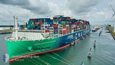
CMA CGM MONTMARTRE
Cargo A
Current Trip
| Time Travelled | 10 days |
|---|---|
| Remaining Time | 12 days |
| Distance Travelled | 5027.32 nm |
| Remaining Distance | 5716.19 nm |
| AVG Speed | 19.3 Knots |
| MAX Speed | 22 Knots |
| AVG Wind | 13 knots |
| MAX Wind | 37.4 knots |
| MIN Temp | 16.9°C / 62.42°F |
| MAX Temp | 29°C / 84.2°F |
| Dybgang | 13.1 m |
| Position Modtaget | 1 m siden |
Current Position
| Longitude | 16.99864° |
|---|---|
| Latitude | -33.41923° |
| Status | Under way using engine |
| Fart | 19 Knots |
| Kurs | 139.9° |
| Område | South Atlantic Ocean |
| Station | T-AIS |
| Position Modtaget | 1 m siden |
Info
Information
The current position of CMA CGM MONTMARTRE is in South Atlantic Ocean with coordinates -33.41923° / 16.99864° as reported on 2024-04-19 05:52 by AIS to our vessel tracker app. The vessel's current speed is 19 Knots and is heading at the port of SINGAPORE. The estimated time of arrival as calculated by MyShipTracking vessel tracking app is 2024-05-01 13:39 LT
The vessel CMA CGM MONTMARTRE (IMO: 9839155, MMSI: 228397700) is a Cargo A It's sailing under the flag of [FR] France.
In this page you can find informations about the vessels current position, last detected port calls, and current voyage information. If the vessels is not in coverage by AIS you will find the latest position.
The current position of CMA CGM MONTMARTRE is detected by our AIS receivers and we are not responsible for the reliability of the data. The last position was recorded while the vessel was in Coverage by the Ais receivers of our vessel tracking app.
The current draught of CMA CGM MONTMARTRE as reported by AIS is 13.1 meters
Weather
| Temperature | 17.3°C / 63.14°F |
|---|---|
| Wind Speed | 13 knots |
| Direction | 159° SSE |
| Pressure | 1016.6 hPa |
| Humidity | 91.5 % |
| Cloud Coverage | 96 % |
Featured Company
Last Port Calls
| Port | Arrival | Departure | Time In Port |
|---|---|---|---|
| 2024-04-06 23:26 | 2024-04-08 13:23 | 1 d | |
| 2024-04-01 03:11 | 2024-04-02 21:19 | 1 d | |
| 2024-03-26 12:05 | 2024-03-29 23:37 | 3 d | |
| 2024-03-22 15:40 | 2024-03-25 19:28 | 3 d | |
| 2024-03-20 23:02 | 2024-03-22 07:03 | 1 d | |
| 2024-03-17 01:48 | 2024-03-17 23:59 | 22 h | |
| 2024-02-17 10:34 | 2024-02-19 06:54 | 1 d | |
| 2024-02-12 09:52 | 2024-02-13 15:10 | 1 d | |
| 2024-02-06 12:29 | 2024-02-07 21:50 | 1 d |
Most Visited Ports (Last year)
| Port | Arrivals | |
|---|---|---|
| 7 | ||
| 6 | ||
| 5 | ||
| 5 | ||
| 4 | ||
| 4 |
Last Trips
| Origin | Departure | Destination | Arrival | Distance | |
|---|---|---|---|---|---|
| 2024-04-02 23:19 | 2024-04-06 23:26 | 1437.95 nm | |||
| 2024-03-29 23:37 | 2024-04-01 05:11 | 275.93 nm | |||
| 2024-03-25 20:28 | 2024-03-26 12:05 | 260.86 nm | |||
| 2024-03-22 08:03 | 2024-03-22 16:40 | 131.96 nm | |||
| 2024-03-17 23:59 | 2024-03-21 00:02 | 1300.97 nm | |||
| 2024-02-19 14:54 | 2024-03-17 01:48 | 10733.99 nm | |||
| 2024-02-13 23:10 | 2024-02-17 18:34 | 1468.96 nm | |||
| 2024-02-08 05:50 | 2024-02-12 17:52 | 908.41 nm | |||
| 2024-01-27 08:25 | 2024-02-06 20:29 | 2565.87 nm |
Events
| Tid | Hændelsen | Detaljer | Position / Dest | Info |
|---|---|---|---|---|
| 2024-04-19 01:55 | Dybgangen er ændret | 13.1 13.7 |
-32.47621 / 15.96597
MAPTM>SGSIN(PWBGA)
|
Fart: 19.7 kn Kurs: 138.8° |
| 2024-04-19 01:55 | ETA er ændret | 2024/05/01 16:00 2024/05/01 21:00 |
-32.47621 / 15.96597
MAPTM>SGSIN(PWBGA)
|
Fart: 19.7 kn Kurs: 138.8° |
| 2024-04-19 01:53 | Ændre havområde | South African part of the South Atlantic Ocean Mauritanian part of the North Atlantic Ocean |
-32.47094 / 15.96045
South Atlantic Ocean
MAPTM>SGSIN(PWBGA)
|
Fart: 19.7 kn Kurs: 137.6° |
| 2024-04-19 01:52 | Status er ændret | Under way using engine Default |
-32.46449 / 15.95344
MAPTM>SGSIN(PWBGA)
|
Fart: 19.5 kn Kurs: 134° |
| 2024-04-19 01:52 | Indenfor Dækning |
-32.47094 / 15.96045
South Atlantic Ocean
MAPTM>SGSIN(PWBGA)
|
Fart: 19.7 kn Kurs: 137.6° |
|
| 2024-04-11 09:08 | Status er ændret | Default Under way using engine |
17.31922 / -17.85425
MAPTM>SGSIN(PWBGA)
|
Fart: 20.1 kn Kurs: 180.3° |
| 2024-04-11 09:00 | Status er ændret | Under way using engine Default |
17.36276 / -17.85377
MAPTM>SGSIN(PWBGA)
|
Fart: 20.2 kn Kurs: 182° |
| 2024-04-11 09:00 | Udenfor Dækning |
17.36276 / -17.85377
North Atlantic Ocean
MAPTM>SGSIN(PWBGA)
|
Fart: 20.1 kn Kurs: 180.3° |
|
| 2024-04-11 08:48 | Status er ændret | Default Under way using engine |
17.43323 / -17.85304
MAPTM>SGSIN(PWBGA)
|
Fart: 20.2 kn Kurs: 182.4° |
| 2024-04-11 08:41 | Ændre havområde | Mauritanian part of the North Atlantic Ocean Western Saharan part of the North Atlantic Ocean |
17.47100 / -17.85199
North Atlantic Ocean
MAPTM>SGSIN(PWBGA)
|
Fart: 20.2 kn Kurs: 182.4° |