
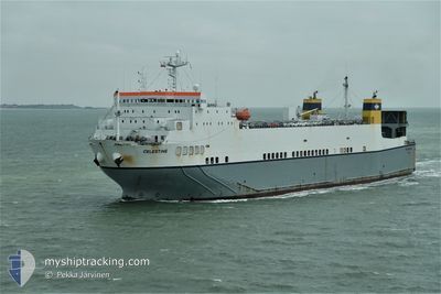
CELESTINE
Ro-Ro Cargo
Current Trip
| Time Travelled | 2 days |
|---|---|
| Remaining Time | --- |
| Distance Travelled | 448.88 nm |
| Remaining Distance | --- |
| AVG Speed | 8.9 Knots |
| MAX Speed | 11 Knots |
| AVG Wind | 11.3 knots |
| MAX Wind | 32.4 knots |
| MIN Temp | 16.4°C / 61.52°F |
| MAX Temp | 23°C / 73.4°F |
| Dybgang | 5 m |
| Position Modtaget | 1 m siden |
Current Position
| Longitude | 25.99359° |
|---|---|
| Latitude | 39.78790° |
| Status | At anchor |
| Fart | |
| Kurs | 190° |
| Område | Aegean Sea |
| Station | T-AIS |
| Position Modtaget | 1 m siden |
Info
Information
The current position of CELESTINE is in Aegean Sea with coordinates 39.78790° / 25.99359° as reported on 2024-04-25 00:28 by AIS to our vessel tracker app. The vessel's current speed is 0 Knots and is heading at the port of IZMIT. The estimated time of arrival as calculated by MyShipTracking vessel tracking app is 2024-04-25 09:00 LT
The vessel CELESTINE (IMO: 9125372, MMSI: 249444000) is a Ro-Ro Cargo that was built in 1996 ( 28 år gamle ). It's sailing under the flag of [MT] Malta.
In this page you can find informations about the vessels current position, last detected port calls, and current voyage information. If the vessels is not in coverage by AIS you will find the latest position.
The current position of CELESTINE is detected by our AIS receivers and we are not responsible for the reliability of the data. The last position was recorded while the vessel was in Coverage by the Ais receivers of our vessel tracking app.
The current draught of CELESTINE as reported by AIS is 5 meters
Weather
| Temperature | 17.3°C / 63.14°F |
|---|---|
| Wind Speed | 8 knots |
| Direction | 185° S |
| Pressure | 1004.6 hPa |
| Humidity | 89.1 % |
| Cloud Coverage | 100 % |
Featured Company
Last Port Calls
| Port | Arrival | Departure | Time In Port |
|---|---|---|---|
| 2024-04-19 06:10 | 2024-04-22 15:26 | 3 d | |
| 2024-04-16 05:10 | 2024-04-16 05:21 | 10 m | |
| 2024-04-16 04:58 | |||
| 2024-04-16 04:55 | |||
| 2024-04-16 01:37 | |||
| 2024-04-16 01:34 | |||
| 2024-04-15 23:52 | |||
| 2024-04-15 23:43 | |||
| 2024-04-15 23:34 | |||
| 2024-04-15 23:31 |
Last Trips
| Origin | Departure | Destination | Arrival | Distance | |
|---|---|---|---|---|---|
| 2024-04-16 08:21 | 2024-04-19 09:10 | 688.95 nm | |||
| 2024-04-04 16:17 | 2024-04-16 08:10 | 659.47 nm | |||
| 2024-04-04 16:17 | 2024-04-16 07:58 | 659.47 nm | |||
| 2024-04-04 16:17 | 2024-04-16 07:55 | 659.46 nm | |||
| 2024-04-04 16:17 | 2024-04-16 04:37 | 659.47 nm | |||
| 2024-04-04 16:17 | 2024-04-16 04:34 | 659.47 nm | |||
| 2024-04-04 16:17 | 2024-04-16 02:52 | 659.46 nm | |||
| 2024-04-04 16:17 | 2024-04-16 02:43 | 659.46 nm | |||
| 2024-04-04 16:17 | 2024-04-16 02:34 | 659.46 nm | |||
| 2024-04-04 16:17 | 2024-04-16 02:31 | 659.47 nm |
Events
| Tid | Hændelsen | Detaljer | Position / Dest | Info |
|---|---|---|---|---|
| 2024-04-24 19:49 | Status er ændret | At anchor Default |
39.78759 / 25.99363
TR IZT
|
Fart: Kurs: -1° |
| 2024-04-24 19:43 | Status er ændret | Default At anchor |
39.78667 / 25.99333
TR IZT
|
Fart: Kurs: 210° |
| 2024-04-24 18:19 | Status er ændret | At anchor Default |
39.78766 / 25.99352
TR IZT
|
Fart: 0.1 kn Kurs: 151° |
| 2024-04-24 18:10 | Status er ændret | Default At anchor |
39.78781 / 25.99321
TR IZT
|
Fart: 0.1 kn Kurs: 142° |
| 2024-04-24 17:37 | Status er ændret | At anchor Default |
39.78682 / 25.99287
TR IZT
|
Fart: 0.3 kn Kurs: 29° |
| 2024-04-24 17:34 | Status er ændret | Default Under way using engine |
39.78701 / 25.99317
TR IZT
|
Fart: 1.3 kn Kurs: 24° |
| 2024-04-24 17:34 | STOP Sejllads | 4.76 nm, South West of BOZCAADA |
39.78701 / 25.99317
TR IZT
|
Fart: 0.3 kn Kurs: 29° |
| 2024-04-24 16:41 | Fundet i havområde | Turkish part of the Aegean Sea |
39.70261 / 25.93111
Aegean Sea
TR IZT
|
Fart: 8.5 kn Kurs: 51.4° |
| 2024-04-24 10:30 | Status er ændret | Under way using engine Default |
38.93166 / 25.37023
TR IZT
|
Fart: 8.7 kn Kurs: 23° |
| 2024-04-24 10:22 | Status er ændret | Default Under way using engine |
38.91211 / 25.35907
TR IZT
|
Fart: 8.7 kn Kurs: 25.3° |