
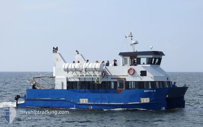
BERTHA K
Passenger
Current Trip
RONBJERG
| Time Travelled | 1 day |
|---|---|
| Remaining Time | --- |
| Distance Travelled | 193.09 nm |
| Remaining Distance | --- |
| AVG Speed | 9.4 Knots |
| MAX Speed | 11.5 Knots |
| AVG Wind | 13.5 knots |
| MAX Wind | 23.6 knots |
| MIN Temp | 2.5°C / 36.5°F |
| MAX Temp | 7.3°C / 45.14°F |
| Dybgang | 1.6 m |
| Position Modtaget | 1 m siden |
Current Position
| Longitude | 9.16472° |
|---|---|
| Latitude | 56.89181° |
| Status | Under way using engine |
| Fart | 0.4 Knots |
| Kurs | --- |
| Område | North Sea |
| Station | T-AIS |
| Position Modtaget | 1 m siden |
Info
Information
The current position of BERTHA K is in North Sea with coordinates 56.89181° / 9.16472° as reported on 2024-04-25 09:31 by AIS to our vessel tracker app. The vessel's current speed is 0.4 Knots
The vessel BERTHA K (MMSI: 219000962) is a Passenger It's sailing under the flag of [DK] Denmark.
In this page you can find informations about the vessels current position, last detected port calls, and current voyage information. If the vessels is not in coverage by AIS you will find the latest position.
The current position of BERTHA K is detected by our AIS receivers and we are not responsible for the reliability of the data. The last position was recorded while the vessel was in Coverage by the Ais receivers of our vessel tracking app.
The current draught of BERTHA K as reported by AIS is 1.6 meters
Weather
| Temperature | 7°C / 44.6°F |
|---|---|
| Wind Speed | 10 knots |
| Direction | 124° SE |
| Pressure | 1004.1 hPa |
| Humidity | 63.5 % |
| Cloud Coverage | 100 % |
Featured Company
Last Port Calls
| Port | Arrival | Departure | Time In Port |
|---|---|---|---|
| 2024-04-23 17:48 | 2024-04-23 17:54 | 6 m | |
| 2024-04-23 17:13 | 2024-04-23 17:26 | 13 m | |
| 2024-04-23 16:29 | 2024-04-23 16:48 | 18 m | |
| 2024-04-23 15:55 | 2024-04-23 16:06 | 11 m | |
| 2024-04-23 15:09 | 2024-04-23 15:29 | 19 m | |
| 2024-04-23 14:30 | 2024-04-23 14:46 | 15 m | |
| 2024-04-23 13:49 | 2024-04-23 14:03 | 14 m | |
| 2024-04-23 13:11 | 2024-04-23 13:21 | 10 m | |
| 2024-04-23 10:07 | 2024-04-23 12:44 | 2 h | |
| 2024-04-23 09:30 | 2024-04-23 09:46 | 16 m |
Last Trips
| Origin | Departure | Destination | Arrival | Distance | |
|---|---|---|---|---|---|
| 2024-04-23 19:26 | 2024-04-23 19:48 | 3.32 nm | |||
| 2024-04-23 18:48 | 2024-04-23 19:13 | 3.14 nm | |||
| 2024-04-23 18:06 | 2024-04-23 18:29 | 2.52 nm | |||
| 2024-04-23 17:29 | 2024-04-23 17:55 | 3.09 nm | |||
| 2024-04-23 16:46 | 2024-04-23 17:09 | 2.63 nm | |||
| 2024-04-23 16:03 | 2024-04-23 16:30 | 3.09 nm | |||
| 2024-04-23 15:21 | 2024-04-23 15:49 | 3.32 nm | |||
| 2024-04-23 14:44 | 2024-04-23 15:11 | 3.14 nm | |||
| 2024-04-23 11:46 | 2024-04-23 12:07 | 3.27 nm | |||
| 2024-04-23 11:03 | 2024-04-23 11:30 | 3.08 nm |
Events
| Tid | Hændelsen | Detaljer | Position / Dest | Info |
|---|---|---|---|---|
| 2024-04-25 09:15 | START Sejllads | 9.66 nm, North East of NYKOBING MORS |
56.88589 / 9.10307
RONBJERG
|
Fart: 8.3 kn Kurs: 90.5° |
| 2024-04-25 08:51 | STOP Sejllads | 9.57 nm, North East of NYKOBING MORS |
56.88614 / 9.09909
RONBJERG
|
Fart: 0.1 kn Kurs: 511° |
| 2024-04-25 08:34 | START Sejllads | 11.42 nm, North East of NYKOBING MORS |
56.89181 / 9.16041
RONBJERG
|
Fart: 7.7 kn Kurs: 259.5° |
| 2024-04-25 06:22 | STOP Sejllads | 11.54 nm, North East of NYKOBING MORS |
56.89180 / 9.16476
RONBJERG
|
Fart: 0.3 kn Kurs: 511° |
| 2024-04-25 06:04 | START Sejllads | 9.66 nm, North East of NYKOBING MORS |
56.88596 / 9.10292
RONBJERG
|
Fart: 7.6 kn Kurs: 89.2° |
| 2024-04-25 05:50 | STOP Sejllads | 9.57 nm, North East of NYKOBING MORS |
56.88613 / 9.09909
RONBJERG
|
Fart: 0.3 kn Kurs: 511° |
| 2024-04-25 05:33 | START Sejllads | 11.44 nm, North East of NYKOBING MORS |
56.89192 / 9.16111
RONBJERG
|
Fart: 7.9 kn Kurs: 264.1° |
| 2024-04-24 13:36 | STOP Sejllads | 11.54 nm, North East of NYKOBING MORS |
56.89176 / 9.16474
RONBJERG
|
Fart: 0.3 kn Kurs: 511° |
| 2024-04-24 12:11 | Ændre havområde | Danish part of the North Sea Danish part of the Kattegat |
57.01581 / 9.37510
North Sea
RONBJERG
|
Fart: 9.5 kn Kurs: 274.5° |
| 2024-04-23 17:54 | Afsejlet fra sidste havn |
|
54.94298 / 10.70655
RONBJERG
|
Fart: 10 kn Kurs: 11.4° |