
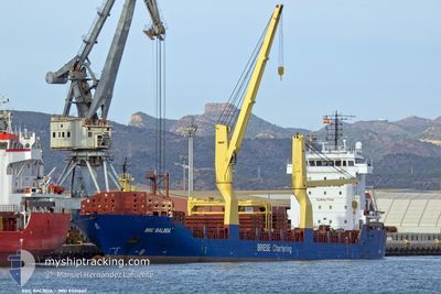
BBC BALBOA
General Cargo
Current Trip
| Time Travelled | 8 days |
|---|---|
| Remaining Time | --- |
| Distance Travelled | 1284.29 nm |
| Remaining Distance | --- |
| AVG Speed | 8.8 Knots |
| MAX Speed | 11.9 Knots |
| AVG Wind | 14 knots |
| MAX Wind | 30.3 knots |
| MIN Temp | 8.4°C / 47.12°F |
| MAX Temp | 20.1°C / 68.18°F |
| Dybgang | 7.2 m |
| Position Modtaget | 3 d siden |
Current Position
| Longitude | 29.51701° |
|---|---|
| Latitude | 41.30550° |
| Status | Under way using engine |
| Fart | 10.8 Knots |
| Kurs | 82.3° |
| Område | Black Sea |
| Station | T-AIS |
| Position Modtaget | 3 d siden |
Info
Information
The current position of BBC BALBOA is in Black Sea with coordinates 41.30550° / 29.51701° as reported on 2024-04-21 02:51 by AIS to our vessel tracker app. The vessel's current speed is 10.8 Knots and is heading at the port of ZONGULDAK. The estimated time of arrival as calculated by MyShipTracking vessel tracking app is 2024-04-21 13:00 LT
The vessel BBC BALBOA (IMO: 9501667, MMSI: 305730000) is a General Cargo that was built in 2012 ( 12 år gamle ). It's sailing under the flag of [AG] Antigua Barbuda.
In this page you can find informations about the vessels current position, last detected port calls, and current voyage information. If the vessels is not in coverage by AIS you will find the latest position.
The current position of BBC BALBOA is detected by our AIS receivers and we are not responsible for the reliability of the data. The last position was recorded while the vessel was in Coverage by the Ais receivers of our vessel tracking app.
The current draught of BBC BALBOA as reported by AIS is 7.2 meters
Weather
| Temperature | 17.5°C / 63.5°F |
|---|---|
| Wind Speed | 2 knots |
| Direction | 28° NNE |
| Pressure | 1006.6 hPa |
| Humidity | 69.1 % |
| Cloud Coverage | 100 % |
Featured Company
Last Port Calls
| Port | Arrival | Departure | Time In Port |
|---|---|---|---|
| 2024-04-11 14:13 | 2024-04-15 21:34 | 4 d | |
| 2024-04-09 04:22 | 2024-04-10 18:32 | 1 d | |
| 2024-04-02 10:57 | 2024-04-04 13:05 | 2 d | |
| 2024-03-26 20:24 | 2024-03-28 11:34 | 1 d | |
| 2024-03-26 06:44 | |||
| 2024-03-08 16:08 | 2024-03-11 02:15 | 2 d | |
| 2024-03-02 11:28 | 2024-03-07 01:16 | 4 d | |
| 2024-02-17 00:39 | 2024-02-17 01:26 | 46 m | |
| 2024-02-10 17:43 | 2024-02-16 13:48 | 5 d | |
| 2024-02-01 04:45 | 2024-02-02 22:29 | 1 d |
Most Visited Ports (Last year)
| Port | Arrivals | |
|---|---|---|
| 4 | ||
| 3 | ||
| 3 | ||
| 3 | ||
| 2 | ||
| 2 |
Last Trips
| Origin | Departure | Destination | Arrival | Distance | |
|---|---|---|---|---|---|
| 2024-04-10 20:32 | 2024-04-11 16:13 | 179.84 nm | |||
| 2024-04-04 15:05 | 2024-04-09 06:22 | 1043.72 nm | |||
| 2024-03-28 12:34 | 2024-04-02 12:57 | 1249.46 nm | |||
| 2024-03-26 07:44 | 2024-03-26 21:24 | 153.12 nm | |||
| 2024-03-07 04:16 | 2024-03-08 19:08 | 44.72 nm | |||
| 2024-02-17 02:26 | 2024-03-02 14:28 | 3367.29 nm | |||
| 2024-02-16 14:48 | 2024-02-17 01:39 | 87.38 nm | |||
| 2024-02-02 23:29 | 2024-02-10 18:43 | 1555.57 nm | |||
| 2024-01-29 18:57 | 2024-02-01 05:45 | 527.60 nm |
Events
| Tid | Hændelsen | Detaljer | Position / Dest | Info |
|---|---|---|---|---|
| 2024-04-21 14:52 | STOP Sejllads | 8.33 nm, North East of EREN |
41.58573 / 32.06666
TRZON
|
Fart: 0.1 kn Kurs: 162° |
| 2024-04-21 02:53 | Status er ændret | Default Under way using engine |
41.30614 / 29.52371
TRZON
|
Fart: 10.8 kn Kurs: 82.3° |
| 2024-04-21 02:51 | Udenfor Dækning |
41.30550 / 29.51701
Black Sea
TRZON
|
Fart: 10.8 kn Kurs: 82.3° |
|
| 2024-04-21 01:14 | Ændre havområde | Turkish part of the Black Sea Turkish part of the Sea of Marmara |
41.23282 / 29.15062
Black Sea
TRZON
|
Fart: 10.1 kn Kurs: 43.9° |
| 2024-04-21 01:12 | ETA er ændret | 2024/04/21 13:00 2024/04/20 13:00 |
41.22916 / 29.14588
TRZON
|
Fart: 9.7 kn Kurs: 45.4° |
| 2024-04-20 20:12 | START Sejllads | 10.54 nm, South of YESILKOY |
40.77967 / 28.83328
TRZON
|
Fart: 3.1 kn Kurs: 320° |
| 2024-04-20 17:46 | STOP Sejllads | 10.01 nm, South of YESILKOY |
40.78976 / 28.85337
TRZON
|
Fart: 0.2 kn Kurs: 317° |
| 2024-04-20 14:18 | Status er ændret | Under way using engine Default |
40.80891 / 28.46439
TRZON
|
Fart: 11.1 kn Kurs: 85° |
| 2024-04-20 14:18 | Indenfor Dækning |
40.80955 / 28.47132
Sea of Marmara
TRZON
|
Fart: 11.1 kn Kurs: 82.8° |
|
| 2024-04-20 12:24 | Udenfor Dækning |
40.76700 / 28.01748
Sea of Marmara
TRZON
|
Fart: 9.8 kn Kurs: 82.6° |