
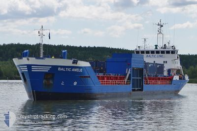
BALTIC AMELIE
General Cargo
Current Trip
| Trip Time | 2 days |
|---|---|
| Trip Distance | 586.36 nm |
| AVG Speed | 8.9 Knots |
| MAX Speed | 11.1 Knots |
| Dybgang | 4.7 m |
| AVG Wind | 16.3 knots |
| MAX Wind | 25 knots |
| MIN Temp | -2.1°C / 28.22°F |
| MAX Temp | 6.8°C / 44.24°F |
| Position Modtaget | 3 m siden |
Current Position
| Longitude | 22.21230° |
|---|---|
| Latitude | 60.43734° |
| Status | Moored |
| Fart | |
| Kurs | 18° |
| Område | Gulf of Bothnia |
| Station | T-AIS |
| Position Modtaget | 3 m siden |
Info
Information
The current position of BALTIC AMELIE is in Gulf of Bothnia with coordinates 60.43734° / 22.21230° as reported on 2024-04-25 04:18 by AIS to our vessel tracker app. The vessel's current speed is 0 Knots and is currently inside the port of TURKU.
The vessel BALTIC AMELIE (IMO: 9083885, MMSI: 230091950) is a General Cargo that was built in 1994 ( 30 år gamle ). It's sailing under the flag of [FI] Finland.
In this page you can find informations about the vessels current position, last detected port calls, and current voyage information. If the vessels is not in coverage by AIS you will find the latest position.
The current position of BALTIC AMELIE is detected by our AIS receivers and we are not responsible for the reliability of the data. The last position was recorded while the vessel was in Coverage by the Ais receivers of our vessel tracking app.
The current draught of BALTIC AMELIE as reported by AIS is 4.7 meters
Weather
| Temperature | 1.7°C / 35.06°F |
|---|---|
| Wind Speed | 7 knots |
| Direction | 60° ENE |
| Pressure | 1008.8 hPa |
| Humidity | 80.9 % |
| Cloud Coverage | 100 % |
Featured Company
Last Port Calls
| Port | Arrival | Departure | Time In Port |
|---|---|---|---|
| 2024-04-23 14:12 | |||
| 2024-04-20 13:37 | 2024-04-20 21:56 | 8 h | |
| 2024-04-19 10:06 | 2024-04-19 14:48 | 4 h | |
| 2024-04-18 13:39 | 2024-04-18 21:36 | 7 h | |
| 2024-04-18 07:11 | 2024-04-18 09:51 | 2 h | |
| 2024-04-17 16:52 | 2024-04-17 21:56 | 5 h | |
| 2024-04-17 09:28 | 2024-04-17 12:31 | 3 h | |
| 2024-04-16 04:51 | 2024-04-16 10:09 | 5 h | |
| 2024-04-10 21:07 | 2024-04-12 06:28 | 1 d | |
| 2024-04-08 07:37 | 2024-04-08 13:46 | 6 h |
Last Trips
| Origin | Departure | Destination | Arrival | Distance | |
|---|---|---|---|---|---|
| 2024-04-20 23:56 | 2024-04-23 17:12 | 586.36 nm | |||
| 2024-04-19 16:48 | 2024-04-20 15:37 | 217.45 nm | |||
| 2024-04-18 23:36 | 2024-04-19 12:06 | 104.65 nm | |||
| 2024-04-18 11:51 | 2024-04-18 15:39 | 35.55 nm | |||
| 2024-04-17 23:56 | 2024-04-18 09:11 | 108.00 nm | |||
| 2024-04-17 14:31 | 2024-04-17 18:52 | 50.11 nm | |||
| 2024-04-16 12:09 | 2024-04-17 11:28 | 256.10 nm | |||
| 2024-04-12 09:28 | 2024-04-16 06:51 | 861.52 nm | |||
| 2024-04-08 15:46 | 2024-04-11 00:07 | 611.59 nm | |||
| 2024-04-06 20:53 | 2024-04-08 09:37 | 379.52 nm |
Events
| Tid | Hændelsen | Detaljer | Position / Dest | Info |
|---|---|---|---|---|
| 2024-04-24 15:18 | Destination er ændret | LVRIX FITKU VIA KALMARSUND |
60.43732 / 22.21229
[FI] TURKU
|
Fart: Kurs: 18° |
| 2024-04-24 15:18 | ETA er ændret | 2024/04/26 13:00 2024/04/23 15:00 |
60.43732 / 22.21229
[FI] TURKU
|
Fart: Kurs: 18° |
| 2024-04-23 14:17 | Status er ændret | Moored Under way using engine |
60.43735 / 22.21232
[FI] TURKU
|
Fart: Kurs: 18° |
| 2024-04-23 14:14 | STOP Sejllads |
60.43732 / 22.21251
[FI] TURKU
|
Fart: 0.3 kn Kurs: 15° |
|
| 2024-04-23 14:12 | Skibe i havn |
|
60.43723 / 22.21295
[FI] TURKU
|
Fart: 0.7 kn Kurs: 4° |
| 2024-04-23 08:35 | Ændre havområde | Finnish part of the Gulf of Bothnia Finnish part of the Baltic Sea |
59.71320 / 21.33132
Gulf of Bothnia
FITKU VIA KALMARSUND
|
Fart: 10.2 kn Kurs: 14.5° |
| 2024-04-23 07:43 | Fundet i havområde | Finnish part of the Baltic Sea |
59.62680 / 21.09440
Baltic Sea
FITKU VIA KALMARSUND
|
Fart: 10.3 kn Kurs: 57.3° |
| 2024-04-23 07:43 | Status er ændret | Under way using engine Default |
59.62680 / 21.09440
FITKU VIA KALMARSUND
|
Fart: 10.4 kn Kurs: 58° |
| 2024-04-23 07:43 | Indenfor Dækning |
59.62680 / 21.09440
Baltic Sea
FITKU VIA KALMARSUND
|
Fart: 10.3 kn Kurs: 57.3° |
|
| 2024-04-22 23:56 | Udenfor Dækning |
58.94282 / 19.02244
Baltic Sea
FITKU VIA KALMARSUND
|
Fart: 9.8 kn Kurs: 57.9° |