
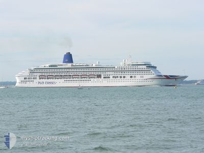
AURORA
Not available
Current Trip
| Time Travelled | 14 h, 6 mins |
|---|---|
| Remaining Time | 20 h, 48 mins |
| Distance Travelled | 227.28 nm |
| Remaining Distance | 354.61 nm |
| AVG Speed | 14.1 Knots |
| MAX Speed | 17 Knots |
| AVG Wind | 10.2 knots |
| MAX Wind | 13 knots |
| MIN Temp | 11.3°C / 52.34°F |
| MAX Temp | 12.6°C / 54.68°F |
| Dybgang | 8.4 m |
| Position Modtaget | 1 m siden |
Current Position
| Longitude | -6.44925° |
|---|---|
| Latitude | 46.87952° |
| Status | Under way using engine |
| Fart | 17 Knots |
| Kurs | 23.4° |
| Område | North Atlantic Ocean |
| Station | T-AIS |
| Position Modtaget | 1 m siden |
Info
Information
The current position of AURORA is in North Atlantic Ocean with coordinates 46.87952° / -6.44925° as reported on 2024-04-25 05:15 by AIS to our vessel tracker app. The vessel's current speed is 17 Knots and is heading at the port of SOUTHAMPTON. The estimated time of arrival as calculated by MyShipTracking vessel tracking app is 2024-04-26 02:04 LT
The vessel AURORA (IMO: 9169524, MMSI: 310556000) is a Not available It's sailing under the flag of [BM] Bermuda.
In this page you can find informations about the vessels current position, last detected port calls, and current voyage information. If the vessels is not in coverage by AIS you will find the latest position.
The current position of AURORA is detected by our AIS receivers and we are not responsible for the reliability of the data. The last position was recorded while the vessel was in Coverage by the Ais receivers of our vessel tracking app.
The current draught of AURORA as reported by AIS is 8.4 meters
Weather
| Temperature | 11°C / 51.8°F |
|---|---|
| Wind Speed | 10 knots |
| Direction | 328° NNW |
| Pressure | 1011.3 hPa |
| Humidity | 78.3 % |
| Cloud Coverage | 100 % |
Featured Company
Last Port Calls
| Port | Arrival | Departure | Time In Port |
|---|---|---|---|
| 2024-04-24 05:06 | 2024-04-24 15:10 | 10 h | |
| 2024-04-22 05:56 | 2024-04-22 17:19 | 11 h | |
| 2024-04-21 05:03 | 2024-04-21 19:46 | 14 h | |
| 2024-04-18 05:14 | 2024-04-18 16:24 | 11 h | |
| 2024-04-17 05:10 | 2024-04-17 17:21 | 12 h | |
| 2024-04-14 04:29 | 2024-04-14 19:37 | 15 h | |
| 2024-04-11 06:32 | 2024-04-11 17:19 | 10 h | |
| 2024-04-11 05:59 | 2024-04-11 06:13 | 13 m | |
| 2024-04-08 04:21 | 2024-04-08 16:17 | 11 h | |
| 2024-04-06 04:19 | 2024-04-06 15:00 | 10 h |
Last Trips
| Origin | Departure | Destination | Arrival | Distance | |
|---|---|---|---|---|---|
| 2024-04-22 18:19 | 2024-04-24 07:06 | 644.02 nm | |||
| 2024-04-21 20:46 | 2024-04-22 06:56 | 170.46 nm | |||
| 2024-04-18 18:24 | 2024-04-21 06:03 | 1058.85 nm | |||
| 2024-04-17 19:21 | 2024-04-18 07:14 | 222.70 nm | |||
| 2024-04-14 21:37 | 2024-04-17 07:10 | 736.37 nm | |||
| 2024-04-11 18:19 | 2024-04-14 06:29 | 863.72 nm | |||
| 2024-04-11 07:13 | 2024-04-11 07:32 | 0.44 nm | |||
| 2024-04-08 17:17 | 2024-04-11 06:59 | 963.33 nm | |||
| 2024-04-06 17:00 | 2024-04-08 05:21 | 497.12 nm | |||
| 2024-04-05 17:25 | 2024-04-06 06:19 | 196.26 nm |
Events
| Tid | Hændelsen | Detaljer | Position / Dest | Info |
|---|---|---|---|---|
| 2024-04-25 05:15 | Dybgangen er ændret | 8.4 8 |
46.87736 / -6.45061
ESFRO>GBSOU
|
Fart: 17 kn Kurs: 23.7° |
| 2024-04-25 05:15 | ETA er ændret | 2024/04/26 02:00 |
46.87736 / -6.45061
ESFRO>GBSOU
|
Fart: 17 kn Kurs: 23.7° |
| 2024-04-25 05:12 | Ændre havområde | French part of the North Atlantic Ocean Spanish part of the North Atlantic Ocean |
46.86478 / -6.45819
North Atlantic Ocean
|
Fart: 16.9 kn Kurs: 22° |
| 2024-04-25 05:12 | Status er ændret | Under way using engine Default |
46.86478 / -6.45819
ESFRO>GBSOU
|
Fart: 17 kn Kurs: 22° |
| 2024-04-25 04:58 | Indenfor Dækning |
46.86478 / -6.45819
North Atlantic Ocean
|
Fart: 16.9 kn Kurs: 22° |
|
| 2024-04-24 21:35 | Status er ændret | Default Under way using engine |
44.90333 / -7.62333
ESFRO>GBSOU
|
Fart: 16.4 kn Kurs: 22° |
| 2024-04-24 21:32 | Udenfor Dækning |
44.89040 / -7.63164
North Atlantic Ocean
|
Fart: 16.4 kn Kurs: 22° |
|
| 2024-04-24 19:56 | Dybgangen er ændret | 8 8.4 |
44.49514 / -7.87260
ESFRO>GBSOU
|
Fart: 15.8 kn Kurs: 24° |
| 2024-04-24 19:34 | Status er ændret | Under way using engine Default |
44.40169 / -7.93061
ESFRO>GBSOU
|
Fart: 16 kn Kurs: 24° |
| 2024-04-24 19:23 | Indenfor Dækning |
44.40580 / -7.92809
North Atlantic Ocean
ESFRO>GBSOU
|
Fart: 16 kn Kurs: 24° |