
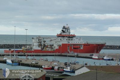
ARGO
Diving Support Vessel
Current Trip
EAST SIFNOS
| Time Travelled | 29 days |
|---|---|
| Remaining Time | --- |
| Distance Travelled | 355.53 nm |
| Remaining Distance | --- |
| AVG Speed | 7.3 Knots |
| MAX Speed | 10.3 Knots |
| AVG Wind | 13.2 knots |
| MAX Wind | 31.7 knots |
| MIN Temp | 13.2°C / 55.76°F |
| MAX Temp | 20.4°C / 68.72°F |
| Dybgang | 6.6 m |
| Position Modtaget | 2 m siden |
Current Position
| Longitude | 24.45503° |
|---|---|
| Latitude | 36.84091° |
| Status | Restricted manoeuverability |
| Fart | 0.8 Knots |
| Kurs | 245° |
| Område | Aegean Sea |
| Station | T-AIS |
| Position Modtaget | 2 m siden |
Info
Information
The current position of ARGO is in Aegean Sea with coordinates 36.84091° / 24.45503° as reported on 2024-04-19 23:09 by AIS to our vessel tracker app. The vessel's current speed is 0.8 Knots
The vessel ARGO (IMO: 9523366, MMSI: 241798000) is a Diving Support Vessel that was built in 2011 ( 13 år gamle ). It's sailing under the flag of [GR] Greece.
In this page you can find informations about the vessels current position, last detected port calls, and current voyage information. If the vessels is not in coverage by AIS you will find the latest position.
The current position of ARGO is detected by our AIS receivers and we are not responsible for the reliability of the data. The last position was recorded while the vessel was in Coverage by the Ais receivers of our vessel tracking app.
The current draught of ARGO as reported by AIS is 6.6 meters
Weather
| Temperature | 15.9°C / 60.62°F |
|---|---|
| Wind Speed | 31 knots |
| Direction | 257° WSW |
| Pressure | 1003.2 hPa |
| Humidity | 69.1 % |
| Cloud Coverage | 70 % |
Featured Company
Last Port Calls
| Port | Arrival | Departure | Time In Port |
|---|---|---|---|
| 2024-03-20 10:11 | 2024-03-21 17:14 | 1 d | |
| 2024-02-27 09:51 | 2024-03-02 13:38 | 4 d | |
| 2024-02-22 04:52 |
Most Visited Ports (Last year)
| Port | Arrivals | |
|---|---|---|
| 6 | ||
| 5 | ||
| 2 | ||
| 2 | ||
| 1 | ||
| 1 |
Events
| Tid | Hændelsen | Detaljer | Position / Dest | Info |
|---|---|---|---|---|
| 2024-04-19 08:09 | STOP Sejllads | 6.98 nm, West of SIFNOS |
36.97031 / 24.52766
EAST SIFNOS
|
Fart: 0.3 kn Kurs: 247° |
| 2024-04-19 07:34 | Destination er ændret | EAST SIFNOS E SERIFO |
36.90431 / 24.49771
EAST SIFNOS
|
Fart: 7.7 kn Kurs: 19.7° |
| 2024-04-19 07:32 | Destination er ændret | E SERIFO SOUTH OF SERIFOS |
36.89987 / 24.49579
E SERIFO
|
Fart: 7.7 kn Kurs: 19.3° |
| 2024-04-19 06:50 | START Sejllads | 4.5 nm, North West of POLLONIA |
36.81752 / 24.46071
SOUTH OF SERIFOS
|
Fart: 5.5 kn Kurs: 18.5° |
| 2024-04-15 05:17 | STOP Sejllads | 4.16 nm, South East of SERIFOS |
37.07692 / 24.55943
SOUTH OF SERIFOS
|
Fart: 0.3 kn Kurs: 163° |
| 2024-04-15 04:57 | START Sejllads | 3.25 nm, South East of SERIFOS |
37.09203 / 24.55441
SOUTH OF SERIFOS
|
Fart: 3.1 kn Kurs: 165° |
| 2024-04-14 23:32 | STOP Sejllads | 1.96 nm, South East of SERIFOS |
37.11084 / 24.54162
SOUTH OF SERIFOS
|
Fart: 0.3 kn Kurs: 36° |
| 2024-04-14 23:28 | Status er ændret | Restricted manoeuverability Under way using engine |
37.10984 / 24.54136
SOUTH OF SERIFOS
|
Fart: 1.2 kn Kurs: 3° |
| 2024-04-14 22:24 | START Sejllads | 6.98 nm, West of SIFNOS |
36.97153 / 24.52737
SOUTH OF SERIFOS
|
Fart: 3.1 kn Kurs: 17° |
| 2024-04-14 22:21 | Status er ændret | Under way using engine Restricted manoeuverability |
36.97060 / 24.52651
SOUTH OF SERIFOS
|
Fart: 0.1 kn Kurs: 26° |